Property Record
Skyview Dr, Brunswick, OH 44212


Property Detail
Skyview Dr
003-18B-07-268
BL A MID PT HOLIDAY HILLS SUB 14.898A
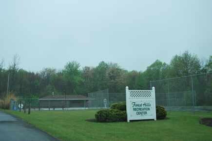
Multifamilydwelling
MEDINA
B and X Area of moderate flood hazard, usually the area between the limits of the 100-year and 500-year floods.
Ohio
2025
14.90 AC
2025
Medina County
415300
Cleveland
6,741 SF
Cleveland-Elyria, OH
NEARBY LISTINGS FOR SALE OR LEASE
DEMOGRAPHICS near Skyview Dr
1 mile
3 mile
5 mile
2025 Total Population
8,924
59,026
101,542
2030 Population
8,906
58,586
101,107
Pop Growth 2025-2030
(0.20%)
(0.75%)
(0.43%)
Average Age
42
43
43
2025 Total Households
3,508
22,828
40,558
HH Growth 2025-2030
(0.17%)
(0.80%)
(0.55%)
Median Household Inc
$99,852
$95,530
$93,902
Avg Household Size
2.50
2.50
2.40
2025 Avg HH Vehicles
2.00
2.00
2.00
Median Home Value
$284,532
$280,777
$286,722
Median Year Built
1981
1983
1982
Nearby Places
Map Layers
Map Styles
 Street
 Aerial
Layers
 Traffic
 Biking
Places
Listings with unknown addresses are not visible on the map
- Restaurants
- Banks
- Shops
- Fitness
- Groceries
PUBLIC TRANSPORTATION
AIRPORT
Cleveland-Hopkins International
Drive
Walk
Distance
Cleveland-Hopkins International
28 min
15.0 mi
Freight Ports
Port of Toledo
Drive
Walk
Distance
Port of Toledo
133 min
107.9 mi
Nearby Properties
Address
Land Use
TOTAL SIZE
Lot Size
Zoning
Address
Land Use
TOTAL SIZE
Lot Size
Zoning
127,666 SF
2.79 AC
Address
Land Use
TOTAL SIZE
Lot Size
Zoning
830,541 SF
51.19 AC
SC
Address
Land Use
TOTAL SIZE
Lot Size
Zoning
242,719 SF
14.97 AC
COMMERCIAL
Address
Land Use
TOTAL SIZE
Lot Size
Zoning
345,524 SF
107.02 AC
PF
Address
Land Use
TOTAL SIZE
Lot Size
Zoning
62,681 SF
5.48 AC
OB
Address
Land Use
TOTAL SIZE
Lot Size
Zoning
13,420 SF
77.80 AC
Address
Land Use
TOTAL SIZE
Lot Size
Zoning
127,666 SF
9.53 AC
Address
Land Use
TOTAL SIZE
Lot Size
Zoning
143,074 SF
25.34 AC
PDA-2
Address
Land Use
TOTAL SIZE
Lot Size
Zoning
437,700 SF
36.09 AC
GI
Address
Land Use
TOTAL SIZE
Lot Size
Zoning
288,114 SF
27.52 AC
GB
Address
Land Use
TOTAL SIZE
Lot Size
Zoning
230,291 SF
17.35 AC
Address
Land Use
TOTAL SIZE
Lot Size
Zoning
124,195 SF
54.96 AC
PF
Address
Land Use
TOTAL SIZE
Lot Size
Zoning
158,432 SF
15.47 AC
Address
Land Use
TOTAL SIZE
Lot Size
Zoning
840 SF
11.60 AC
Address
Land Use
TOTAL SIZE
Lot Size
Zoning
34,195 SF
6.93 AC
COMMERCIAL
Address
Land Use
TOTAL SIZE
Lot Size
Zoning
4,768 SF
3.05 AC
COMMERCIAL
Address
Land Use
TOTAL SIZE
Lot Size
Zoning
149,184 SF
14.09 AC
PDA-2
Address
Land Use
TOTAL SIZE
Lot Size
Zoning
183,240 SF
15.80 AC
SC
Address
Land Use
TOTAL SIZE
Lot Size
Zoning
766 SF
5.26 AC
Address
Land Use
TOTAL SIZE
Lot Size
Zoning
86,693 SF
14.68 AC
COMMERCIAL
Address
Land Use
TOTAL SIZE
Lot Size
Zoning
195.95 AC
PF
Address
Land Use
TOTAL SIZE
Lot Size
Zoning
62,070 SF
18.43 AC
GB
Address
Land Use
TOTAL SIZE
Lot Size
Zoning
95,159 SF
10.97 AC
PF
Address
Land Use
TOTAL SIZE
Lot Size
Zoning
12,751 SF
16.64 AC
Address
Land Use
TOTAL SIZE
Lot Size
Zoning
119,880 SF
11.61 AC
GI
Address
Land Use
TOTAL SIZE
Lot Size
Zoning
14,592 SF
11.01 AC
COMMERCIAL
Address
Land Use
TOTAL SIZE
Lot Size
Zoning
23,448 SF
13.32 AC
COMMERCIAL
Address
Land Use
TOTAL SIZE
Lot Size
Zoning
271,272 SF
25.13 AC
GI
Address
Land Use
TOTAL SIZE
Lot Size
Zoning
128,780 SF
4.79 AC
The World's #1 Commercial Real Estate Marketplace
Connect with us
© 2026 CoStar Group
The information above has been obtained from sources believed reliable. While we do not doubt its accuracy we have not verified it and make no guarantee, warranty or representation about it. It is your responsibility to independently confirm its accuracy and completeness. Any projections, opinions, assumptions, or estimates used are for example only and do not represent the current or future performance of the property. The value of this transaction to you depends on tax and other factors which should be evaluated by your tax, financial, and legal advisors. You and your advisors should conduct a careful, independent investigation of the property to determine to your satisfaction the suitability of the property for your needs.