Property Record
Sorrento Rd, Pensacola, FL 32506

This Property Is For Sale
NEARBY LISTINGS FOR SALE OR LEASE
Property Detail
Sorrento Rd
Pensacola-Ferry Pass-Brent, FL
Subdivision Number: 4000
21-3S-31-4000-000-000
BEG AT NW COR OF SEC S 88 DEG 44 MIN 59 SEC E 50 FT TO E R/W LI OF SR S-293 (100 FT R/W A/K/A/ BAUER RD) S 01 DEG 22 MIN 35 SEC W ALG R/W 1340 FT TO SW COR TARKILN RIDGE EST PB 16 P 17 FOR POB CONT S 01 DEG 22 MIN 35 SEC W ALG R/W 322 30/100 FT TO NW
Commercialacreage
Escambia
AH
Florida
01003C1000M
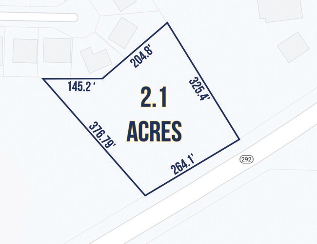
2.10 AC
2024
Perdido
2025
Pensacola
002704
DEMOGRAPHICS near Sorrento Rd
1 Mile
3 Mile
5 Mile
2024 Total Population
1,442
11,651
31,199
2029 Population
1,477
12,013
33,025
Pop Growth 2024-2029
+ 2.43%
+ 3.11%
+ 5.85%
Average Age
41
43
44
2024 Total Households
576
4,814
13,244
HH Growth 2024-2029
+ 2.43%
+ 3.32%
+ 6.46%
Median Household Inc
$76,613
$86,455
$73,994
Avg Household Size
2.50
2.40
2.30
2024 Avg HH Vehicles
2.00
2.00
2.00
Median Home Value
$246,258
$287,531
$274,324
Median Year Built
1990
1996
1997
Nearby Places
Map Layers
Map Styles
 Street
 Aerial
- Restaurants
- Banks
- Shops
- Fitness
- Groceries
PUBLIC TRANSPORTATION
AIRPORT
Pensacola International
DRIVE
WALK
Distance
Pensacola International
33 min
17.7 mi
Freight Ports
Port of Mobile
DRIVE
WALK
Distance
Port of Mobile
78 min
59.0 mi
Nearby Properties
Address
Land Use
TOTAL SIZE
Lot Size
Zoning
Address
Land Use
TOTAL SIZE
Lot Size
Zoning
124.51 AC
NONE
Address
Land Use
TOTAL SIZE
Lot Size
Zoning
379,293 SF
28.14 AC
COM
Address
Land Use
TOTAL SIZE
Lot Size
Zoning
499.23 AC
NONE
Address
Land Use
TOTAL SIZE
Lot Size
Zoning
199,800 SF
14.05 AC
HC/LI
Address
Land Use
TOTAL SIZE
Lot Size
Zoning
193,561 SF
23.31 AC
COM
Address
Land Use
TOTAL SIZE
Lot Size
Zoning
36.04 AC
NONE
Address
Land Use
TOTAL SIZE
Lot Size
Zoning
153,007 SF
6.34 AC
COM
Address
Land Use
TOTAL SIZE
Lot Size
Zoning
208,596 SF
24.20 AC
COM
Address
Land Use
TOTAL SIZE
Lot Size
Zoning
20,818 SF
104.24 AC
NONE
Address
Land Use
TOTAL SIZE
Lot Size
Zoning
193,348 SF
29 AC
COM,HDR
Address
Land Use
TOTAL SIZE
Lot Size
Zoning
138,339 SF
57.97 AC
LDR
Address
Land Use
TOTAL SIZE
Lot Size
Zoning
128,434 SF
11.44 AC
COM
Address
Land Use
TOTAL SIZE
Lot Size
Zoning
74,290 SF
26.17 AC
MDR
Address
Land Use
TOTAL SIZE
Lot Size
Zoning
27,344 SF
4.85 AC
HC/LI
Address
Land Use
TOTAL SIZE
Lot Size
Zoning
66.90 AC
NONE
Address
Land Use
TOTAL SIZE
Lot Size
Zoning
53,189 SF
6.52 AC
COM
Address
Land Use
TOTAL SIZE
Lot Size
Zoning
61,340 SF
2.15 AC
HC/LI
Address
Land Use
TOTAL SIZE
Lot Size
Zoning
36,960 SF
15.78 AC
COM
Address
Land Use
TOTAL SIZE
Lot Size
Zoning
49,787 SF
7.05 AC
HC/LI
Address
Land Use
TOTAL SIZE
Lot Size
Zoning
100,532 SF
25 AC
HDR
Address
Land Use
TOTAL SIZE
Lot Size
Zoning
43,726 SF
14.35 AC
MDR
Address
Land Use
TOTAL SIZE
Lot Size
Zoning
41,837 SF
16.61 AC
MDR
Address
Land Use
TOTAL SIZE
Lot Size
Zoning
51,504 SF
3.53 AC
HC/LI
Address
Land Use
TOTAL SIZE
Lot Size
Zoning
22,320 SF
2.05 AC
HDMU
Address
Land Use
TOTAL SIZE
Lot Size
Zoning
64,000 SF
4.72 AC
COM
Address
Land Use
TOTAL SIZE
Lot Size
Zoning
24,200 SF
3 AC
COM
Address
Land Use
TOTAL SIZE
Lot Size
Zoning
20,157 SF
2.60 AC
COM
Address
Land Use
TOTAL SIZE
Lot Size
Zoning
2,500 SF
32.40 AC
HC/LI
Address
Land Use
TOTAL SIZE
Lot Size
Zoning
13,976 SF
180.60 AC
LDR
Address
Land Use
TOTAL SIZE
Lot Size
Zoning
5,685 SF
9.87 AC
COM
The World's #1 Commercial Real Estate Marketplace
Connect with us
© 2026 CoStar Group
The information above has been obtained from sources believed reliable. While we do not doubt its accuracy we have not verified it and make no guarantee, warranty or representation about it. It is your responsibility to independently confirm its accuracy and completeness. Any projections, opinions, assumptions, or estimates used are for example only and do not represent the current or future performance of the property. The value of this transaction to you depends on tax and other factors which should be evaluated by your tax, financial, and legal advisors. You and your advisors should conduct a careful, independent investigation of the property to determine to your satisfaction the suitability of the property for your needs.