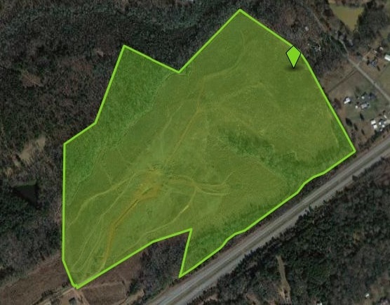
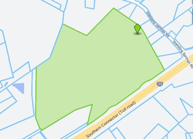
Property Record
Southern Connector, Greenville, SC 29605

NEARBY LISTINGS FOR SALE OR LEASE
Property Detail
Southern Connector
Greenville-Anderson-Mauldin, SC
Chestnut Ridge
0583.02-01-010.03
FUTURE DEVELOPMENT PH1 SEC2
Residentialacreage
Greenville
X
South Carolina
45045C0477E
010.03
2025
74.92 AC
2024
Western Greenville County
002103
Greenville/Spartanburg
DEMOGRAPHICS near Southern Connector
1 Mile
3 Mile
5 Mile
2024 Total Population
3,622
33,284
94,913
2029 Population
4,097
37,037
105,369
Pop Growth 2024-2029
+ 13.11%
+ 11.28%
+ 11.02%
Average Age
37
39
39
2024 Total Households
1,345
12,405
37,329
HH Growth 2024-2029
+ 13.16%
+ 11.37%
+ 11.11%
Median Household Inc
$71,324
$78,971
$71,072
Avg Household Size
2.60
2.70
2.50
2024 Avg HH Vehicles
2.00
2.00
2.00
Median Home Value
$168,220
$230,717
$223,564
Median Year Built
2008
2002
1996
Nearby Places
Map Layers
Map Styles
 Street
 Aerial
- Restaurants
- Banks
- Shops
- Fitness
- Groceries
PUBLIC TRANSPORTATION
AIRPORT
Greenville Spartanburg International
DRIVE
WALK
Distance
Greenville Spartanburg International
25 min
17.5 mi
Freight Ports
North Charleston Terminal
DRIVE
WALK
Distance
North Charleston Terminal
220 min
196.1 mi
Nearby Properties
Address
Land Use
TOTAL SIZE
Lot Size
Zoning
Address
Land Use
TOTAL SIZE
Lot Size
Zoning
977.33 AC
I1
Address
Land Use
TOTAL SIZE
Lot Size
Zoning
14.13 AC
Address
Land Use
TOTAL SIZE
Lot Size
Zoning
8.97 AC
Address
Land Use
TOTAL SIZE
Lot Size
Zoning
13.90 AC
I1
Address
Land Use
TOTAL SIZE
Lot Size
Zoning
12.85 AC
I1
Address
Land Use
TOTAL SIZE
Lot Size
Zoning
13.36 AC
I1
Address
Land Use
TOTAL SIZE
Lot Size
Zoning
11 AC
I1
Address
Land Use
TOTAL SIZE
Lot Size
Zoning
45.10 AC
I1
Address
Land Use
TOTAL SIZE
Lot Size
Zoning
91.92 AC
I1
Address
Land Use
TOTAL SIZE
Lot Size
Zoning
8.14 AC
I1
Address
Land Use
TOTAL SIZE
Lot Size
Zoning
1,176 SF
126.24 AC
RS
Address
Land Use
TOTAL SIZE
Lot Size
Zoning
75.52 AC
I1
Address
Land Use
TOTAL SIZE
Lot Size
Zoning
59 AC
RS
Address
Land Use
TOTAL SIZE
Lot Size
Zoning
54.61 AC
RS
Address
Land Use
TOTAL SIZE
Lot Size
Zoning
14.68 AC
I1
Address
Land Use
TOTAL SIZE
Lot Size
Zoning
17.65 AC
ID
Address
Land Use
TOTAL SIZE
Lot Size
Zoning
65.40 AC
RS
Address
Land Use
TOTAL SIZE
Lot Size
Zoning
21.33 AC
Address
Land Use
TOTAL SIZE
Lot Size
Zoning
1,145 SF
8.89 AC
R15
Address
Land Use
TOTAL SIZE
Lot Size
Zoning
209.74 AC
I1
Address
Land Use
TOTAL SIZE
Lot Size
Zoning
23.98 AC
I1
Address
Land Use
TOTAL SIZE
Lot Size
Zoning
17.50 AC
I1
Address
Land Use
TOTAL SIZE
Lot Size
Zoning
4.10 AC
I1
Address
Land Use
TOTAL SIZE
Lot Size
Zoning
25.80 AC
I1
Address
Land Use
TOTAL SIZE
Lot Size
Zoning
14.50 AC
I1
Address
Land Use
TOTAL SIZE
Lot Size
Zoning
1,450 SF
8.78 AC
R12
Address
Land Use
TOTAL SIZE
Lot Size
Zoning
3.28 AC
RS
Address
Land Use
TOTAL SIZE
Lot Size
Zoning
85.90 AC
I1
Address
Land Use
TOTAL SIZE
Lot Size
Zoning
17.37 AC
I1
The World's #1 Commercial Real Estate Marketplace
Connect with us
© 2025 CoStar Group
The information above has been obtained from sources believed reliable. While we do not doubt its accuracy we have not verified it and make no guarantee, warranty or representation about it. It is your responsibility to independently confirm its accuracy and completeness. Any projections, opinions, assumptions, or estimates used are for example only and do not represent the current or future performance of the property. The value of this transaction to you depends on tax and other factors which should be evaluated by your tax, financial, and legal advisors. You and your advisors should conduct a careful, independent investigation of the property to determine to your satisfaction the suitability of the property for your needs.