Property Record
Southgate Ct, Sarasota, FL 34243

Save to a Folder
{{folder.Name}}
{{folder.ListingIds.length}} Properties
{{folder.ListingIds.length}} Property
Create a New Folder
This Property Is For Sale
Property Detail
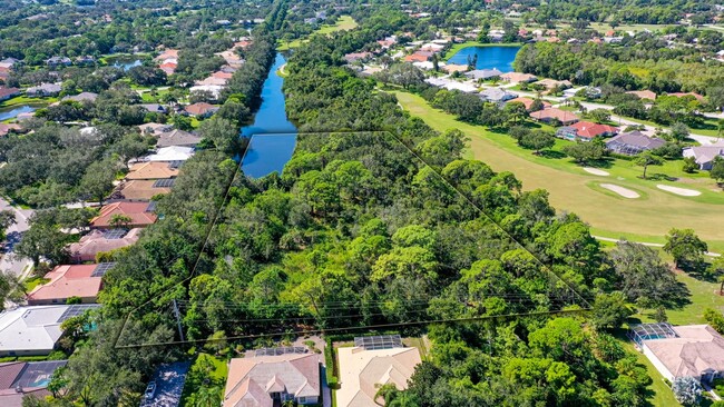
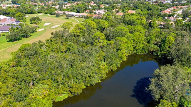
Southgate Ct
North Port-Bradenton-Sarasota, FL
PARCEL 1-C CEDAR CREEK PARCEL, DESC AS FOLLOWS; COM AT SE COR OF SEC 27; TH N 00 DEG 53 MIN 46 SEC W, ALG E LN OF SD SEC, 2106.11 FT FOR A POB; TH CONT N 00 DEG 53 MIN 46 SEC W,
19208-0005-7
MANATEE
Vacantlandnec
Florida
PD-R
1-c
A Areas with a 1% annual chance of flooding and a 26% chance of flooding over the life of a 30-year mortgage.
3.69 AC
2025
Manatee
2026
Tampa/St Petersburg
000808
NEARBY LISTINGS FOR SALE OR LEASE
DEMOGRAPHICS near Southgate Ct
1 mile
3 mile
5 mile
2025 Total Population
5,642
55,059
143,175
2030 Population
6,298
60,754
157,061
Pop Growth 2025-2030
+ 11.63%
+ 10.34%
+ 9.70%
Average Age
59
51
48
2025 Total Households
2,887
26,341
63,134
HH Growth 2025-2030
+ 11.78%
+ 10.57%
+ 9.85%
Median Household Inc
$104,882
$92,949
$87,110
Avg Household Size
1.90
2.00
2.20
2025 Avg HH Vehicles
2.00
2.00
2.00
Median Home Value
$598,819
$465,238
$444,403
Median Year Built
1997
1999
1995
Nearby Places
Map Layers
Map Styles
 Street
 Aerial
Layers
 Traffic
 Biking
Places
Listings with unknown addresses are not visible on the map
- Restaurants
- Banks
- Shops
- Fitness
- Groceries
PUBLIC TRANSPORTATION
AIRPORT
Sarasota/Bradenton International
Drive
Walk
Distance
Sarasota/Bradenton International
19 min
8.3 mi
Freight Ports
Port Manatee
Drive
Walk
Distance
Port Manatee
37 min
21.2 mi
Nearby Properties
Address
Land Use
TOTAL SIZE
Lot Size
Zoning
Address
Land Use
TOTAL SIZE
Lot Size
Zoning
668,194 SF
45.91 AC
CG
Address
Land Use
TOTAL SIZE
Lot Size
Zoning
617,341 SF
76.40 AC
PD-MU
Address
Land Use
TOTAL SIZE
Lot Size
Zoning
434,419 SF
49.04 AC
CG
Address
Land Use
TOTAL SIZE
Lot Size
Zoning
486,203 SF
40.94 AC
RMF3
Address
Land Use
TOTAL SIZE
Lot Size
Zoning
385,610 SF
32.65 AC
RMF-6 MULT
Address
Land Use
TOTAL SIZE
Lot Size
Zoning
326,645 SF
17.96 AC
RMF3
Address
Land Use
TOTAL SIZE
Lot Size
Zoning
272,602 SF
28.35 AC
PD-R
Address
Land Use
TOTAL SIZE
Lot Size
Zoning
353,888 SF
22.83 AC
PD-MU
Address
Land Use
TOTAL SIZE
Lot Size
Zoning
358,441 SF
31.80 AC
PD-R
Address
Land Use
TOTAL SIZE
Lot Size
Zoning
483,594 SF
23.32 AC
PD-MU
Address
Land Use
TOTAL SIZE
Lot Size
Zoning
241,504 SF
27.72 AC
A GENERAL
Address
Land Use
TOTAL SIZE
Lot Size
Zoning
251,472 SF
11 AC
RSF2
Address
Land Use
TOTAL SIZE
Lot Size
Zoning
303,515 SF
36.98 AC
PD-MU
Address
Land Use
TOTAL SIZE
Lot Size
Zoning
255,092 SF
71.44 AC
PD-MU
Address
Land Use
TOTAL SIZE
Lot Size
Zoning
296,343 SF
26.53 AC
PD-R
Address
Land Use
TOTAL SIZE
Lot Size
Zoning
207,583 SF
9.48 AC
Address
Land Use
TOTAL SIZE
Lot Size
Zoning
264,317 SF
9.55 AC
PD-MU
Address
Land Use
TOTAL SIZE
Lot Size
Zoning
132,940 SF
15.70 AC
PD-MU
Address
Land Use
TOTAL SIZE
Lot Size
Zoning
343,415 SF
31.02 AC
PD-C
Address
Land Use
TOTAL SIZE
Lot Size
Zoning
238,774 SF
15.56 AC
A-1 SUBURB
Address
Land Use
TOTAL SIZE
Lot Size
Zoning
179,670 SF
8.57 AC
LM LIGHT M
Address
Land Use
TOTAL SIZE
Lot Size
Zoning
11,248 SF
541.47 AC
GU
Address
Land Use
TOTAL SIZE
Lot Size
Zoning
126,111 SF
38.38 AC
RSF2
Address
Land Use
TOTAL SIZE
Lot Size
Zoning
227,842 SF
12.97 AC
PD-C
Address
Land Use
TOTAL SIZE
Lot Size
Zoning
160,328 SF
11.75 AC
RMF-6 MULT
Address
Land Use
TOTAL SIZE
Lot Size
Zoning
63,064 SF
33.29 AC
GU
Address
Land Use
TOTAL SIZE
Lot Size
Zoning
179,670 SF
3.51 AC
LM LIGHT M
Address
Land Use
TOTAL SIZE
Lot Size
Zoning
190,299 SF
4.43 AC
PD-MU
Address
Land Use
TOTAL SIZE
Lot Size
Zoning
155,000 SF
23.72 AC
PD-C
Address
Land Use
TOTAL SIZE
Lot Size
Zoning
53,916 SF
6.59 AC
CG
The World's #1 Commercial Real Estate Marketplace
Connect with us
© 2026 CoStar Group
The information above has been obtained from sources believed reliable. While we do not doubt its accuracy we have not verified it and make no guarantee, warranty or representation about it. It is your responsibility to independently confirm its accuracy and completeness. Any projections, opinions, assumptions, or estimates used are for example only and do not represent the current or future performance of the property. The value of this transaction to you depends on tax and other factors which should be evaluated by your tax, financial, and legal advisors. You and your advisors should conduct a careful, independent investigation of the property to determine to your satisfaction the suitability of the property for your needs.