No Photo
Property Record
Southport Rd, Roebuck, SC 29376
NEARBY LISTINGS FOR SALE OR LEASE
Property Detail
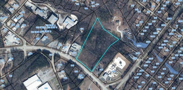
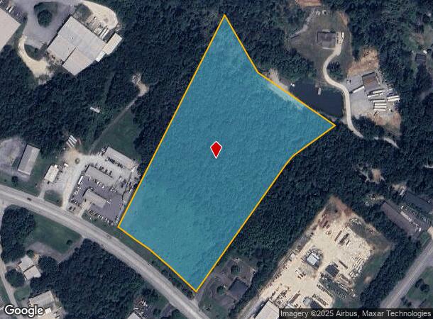
Southport Rd
Spartanburg, SC
Cavalier Properties
6-25-00-188.00
N SIDE SOUTHPORT RD & W OF S CHURCH ST EXT PB 161-50
Commercialacreage
Spartanburg
X
South Carolina
45083C0262D
4
2024
12.06 AC
2025
West Side
023803
Greenville/Spartanburg
DEMOGRAPHICS near Southport Rd
1 Mile
3 Mile
5 Mile
2024 Total Population
2,121
41,435
93,196
2029 Population
2,408
47,172
105,812
Pop Growth 2024-2029
+ 13.53%
+ 13.85%
+ 13.54%
Average Age
38
38
39
2024 Total Households
795
16,800
36,929
HH Growth 2024-2029
+ 13.84%
+ 14.10%
+ 13.98%
Median Household Inc
$61,827
$44,792
$49,972
Avg Household Size
2.60
2.40
2.40
2024 Avg HH Vehicles
3.00
2.00
2.00
Median Home Value
$124,227
$147,408
$174,217
Median Year Built
1986
1976
1979
Nearby Places
Map Layers
Map Styles
 Street
 Aerial
- Restaurants
- Banks
- Shops
- Fitness
- Groceries
PUBLIC TRANSPORTATION
COMMUTER RAIL
Spartanburg Amtrak Station (Crescent - Amtrak)
DRIVE
WALK
Distance
Spartanburg Amtrak Station (Crescent - Amtrak)
9 min
4.3 mi
AIRPORT
Greenville Spartanburg International
DRIVE
WALK
Distance
Greenville Spartanburg International
32 min
19.6 mi
Freight Ports
North Charleston Terminal
DRIVE
WALK
Distance
North Charleston Terminal
215 min
190.9 mi
SALE & LEASE HISTORY
LISTING DATE
SALE/LEASE

Sep 24, 2016
For Sale
Oct 25, 2018
For Sale
May 25, 2017
For Sale
Jun 28, 2021
For Sale
Jan 09, 2025
For Sale
Nearby Properties
Address
Land Use
TOTAL SIZE
Lot Size
Zoning
Address
Land Use
TOTAL SIZE
Lot Size
Zoning
5,130 SF
19.69 AC
Address
Land Use
TOTAL SIZE
Lot Size
Zoning
3,352 SF
14 AC
Address
Land Use
TOTAL SIZE
Lot Size
Zoning
2,134 SF
27.72 AC
Address
Land Use
TOTAL SIZE
Lot Size
Zoning
2,112 SF
5.26 AC
Address
Land Use
TOTAL SIZE
Lot Size
Zoning
6,148 SF
4.18 AC
Address
Land Use
TOTAL SIZE
Lot Size
Zoning
7,245 SF
18.10 AC
Address
Land Use
TOTAL SIZE
Lot Size
Zoning
2,100 SF
10.12 AC
Address
Land Use
TOTAL SIZE
Lot Size
Zoning
3,171 SF
21.41 AC
Address
Land Use
TOTAL SIZE
Lot Size
Zoning
2,297 SF
42.76 AC
Address
Land Use
TOTAL SIZE
Lot Size
Zoning
40,995 SF
0.74 AC
Address
Land Use
TOTAL SIZE
Lot Size
Zoning
31,913 SF
1.03 AC
Address
Land Use
TOTAL SIZE
Lot Size
Zoning
30,016 SF
1.07 AC
Address
Land Use
TOTAL SIZE
Lot Size
Zoning
31,054 SF
0.48 AC
Address
Land Use
TOTAL SIZE
Lot Size
Zoning
3,072 SF
5.60 AC
Address
Land Use
TOTAL SIZE
Lot Size
Zoning
2,022 SF
3.50 AC
Address
Land Use
TOTAL SIZE
Lot Size
Zoning
2,864 SF
3.72 AC
Address
Land Use
TOTAL SIZE
Lot Size
Zoning
227,480 SF
22.22 AC
Address
Land Use
TOTAL SIZE
Lot Size
Zoning
109,024 SF
2.30 AC
Address
Land Use
TOTAL SIZE
Lot Size
Zoning
25,380 SF
0.75 AC
Address
Land Use
TOTAL SIZE
Lot Size
Zoning
6,907 SF
17.39 AC
Address
Land Use
TOTAL SIZE
Lot Size
Zoning
1,475 SF
9.27 AC
Address
Land Use
TOTAL SIZE
Lot Size
Zoning
128,060 SF
18.70 AC
Address
Land Use
TOTAL SIZE
Lot Size
Zoning
212,111 SF
14.11 AC
Address
Land Use
TOTAL SIZE
Lot Size
Zoning
337,199 SF
2.17 AC
Address
Land Use
TOTAL SIZE
Lot Size
Zoning
10,216 SF
3.03 AC
Address
Land Use
TOTAL SIZE
Lot Size
Zoning
159,150 SF
16.37 AC
Address
Land Use
TOTAL SIZE
Lot Size
Zoning
131,965 SF
12.20 AC
Address
Land Use
TOTAL SIZE
Lot Size
Zoning
1,612 SF
8.44 AC
Address
Land Use
TOTAL SIZE
Lot Size
Zoning
15,302 SF
0.74 AC
Address
Land Use
TOTAL SIZE
Lot Size
Zoning
20,844 SF
15 AC
The World's #1 Commercial Real Estate Marketplace
Connect with us
© 2025 CoStar Group
The information above has been obtained from sources believed reliable. While we do not doubt its accuracy we have not verified it and make no guarantee, warranty or representation about it. It is your responsibility to independently confirm its accuracy and completeness. Any projections, opinions, assumptions, or estimates used are for example only and do not represent the current or future performance of the property. The value of this transaction to you depends on tax and other factors which should be evaluated by your tax, financial, and legal advisors. You and your advisors should conduct a careful, independent investigation of the property to determine to your satisfaction the suitability of the property for your needs.