Property Record
Southside Rd, Frankfort, NY 13340
NEARBY LISTINGS FOR SALE OR LEASE
-
-
View all Frankfort listings for sale on LoopNet.com
Property Detail
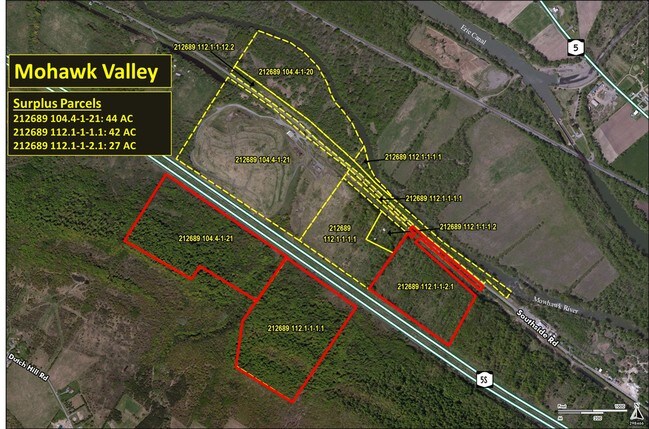
Southside Rd
Utica/Rome
B LANDFILL W RIVER RD
Utica-Rome, NY
Herkimer
212689-112-001-0001-001-200-0000
New York
Miscresidentialimprovement
1.100
2025
4.10 AC
2024
Herkimer County
010202
DEMOGRAPHICS near Southside Rd
1 Mile
3 Mile
5 Mile
2024 Total Population
132
3,039
31,588
2029 Population
131
3,005
30,720
Pop Growth 2024-2029
(0.76%)
(1.12%)
(2.75%)
Average Age
42
45
41
2024 Total Households
51
1,279
12,688
HH Growth 2024-2029
0.00%
(1.25%)
(2.77%)
Median Household Inc
$90,277
$66,461
$49,159
Avg Household Size
2.50
2.30
2.30
2024 Avg HH Vehicles
2.00
2.00
2.00
Median Home Value
$237,500
$163,988
$137,988
Median Year Built
1979
1980
1954
Nearby Places
- Restaurants
- Banks
- Shops
- Fitness
- Groceries
PUBLIC TRANSPORTATION
COMMUTER RAIL
Utica Amtrak Station (Empire Service - Amtrak, Lake Shore Limited - Amtrak, Maple Leaf - Amtrak)
DRIVE
WALK
Distance
Utica Amtrak Station (Empire Service - Amtrak, Lake Shore Limited - Amtrak, Maple Leaf - Amtrak)
11 min
5.9 mi
Utica (Toronto - New York - VIA Rail)
DRIVE
WALK
Distance
Utica (Toronto - New York - VIA Rail)
12 min
6.0 mi
Freight Ports
Albany, NY Port
DRIVE
WALK
Distance
Albany, NY Port
114 min
88.7 mi
SALE & LEASE HISTORY
LISTING DATE
SALE/LEASE

Sep 24, 2016
For Sale
Nearby Properties
Address
Land Use
TOTAL SIZE
Lot Size
Zoning
Address
Land Use
TOTAL SIZE
Lot Size
Zoning
1 AC
RA
Address
Land Use
TOTAL SIZE
Lot Size
Zoning
931,161 SF
141.90 AC
Address
Land Use
TOTAL SIZE
Lot Size
Zoning
195,000 SF
49.40 AC
CH
Address
Land Use
TOTAL SIZE
Lot Size
Zoning
61,000 SF
9.90 AC
CH
Address
Land Use
TOTAL SIZE
Lot Size
Zoning
52,500 SF
11 AC
CH
Address
Land Use
TOTAL SIZE
Lot Size
Zoning
50,000 SF
11.50 AC
CH
Address
Land Use
TOTAL SIZE
Lot Size
Zoning
141,072 SF
18.70 AC
Address
Land Use
TOTAL SIZE
Lot Size
Zoning
14.30 AC
RA
Address
Land Use
TOTAL SIZE
Lot Size
Zoning
16,502 SF
4.76 AC
CH
Address
Land Use
TOTAL SIZE
Lot Size
Zoning
1,080 SF
43.30 AC
CH
Address
Land Use
TOTAL SIZE
Lot Size
Zoning
1,152 SF
40.70 AC
RA
Address
Land Use
TOTAL SIZE
Lot Size
Zoning
131.40 AC
Address
Land Use
TOTAL SIZE
Lot Size
Zoning
138,950 SF
14.60 AC
R
Address
Land Use
TOTAL SIZE
Lot Size
Zoning
16.93 AC
R
Address
Land Use
TOTAL SIZE
Lot Size
Zoning
38,750 SF
3.90 AC
Address
Land Use
TOTAL SIZE
Lot Size
Zoning
117,260 SF
11.50 AC
CH
Address
Land Use
TOTAL SIZE
Lot Size
Zoning
80,000 SF
8 AC
A
Address
Land Use
TOTAL SIZE
Lot Size
Zoning
16,400 SF
3.60 AC
R
Address
Land Use
TOTAL SIZE
Lot Size
Zoning
1,568 SF
11 AC
CH
Address
Land Use
TOTAL SIZE
Lot Size
Zoning
50,138 SF
25 AC
R
Address
Land Use
TOTAL SIZE
Lot Size
Zoning
780 SF
9.60 AC
CH
Address
Land Use
TOTAL SIZE
Lot Size
Zoning
3.80 AC
CH
Address
Land Use
TOTAL SIZE
Lot Size
Zoning
131.40 AC
Address
Land Use
TOTAL SIZE
Lot Size
Zoning
13,308 SF
3.60 AC
Address
Land Use
TOTAL SIZE
Lot Size
Zoning
7.70 AC
CH
Address
Land Use
TOTAL SIZE
Lot Size
Zoning
0.30 AC
CH
Address
Land Use
TOTAL SIZE
Lot Size
Zoning
65,100 SF
9.80 AC
R
Address
Land Use
TOTAL SIZE
Lot Size
Zoning
22,788 SF
9 AC
CH
Address
Land Use
TOTAL SIZE
Lot Size
Zoning
63,000 SF
4.40 AC
R
The World's #1 Commercial Real Estate Marketplace
Connect with us
© 2025 CoStar Group
The information above has been obtained from sources believed reliable. While we do not doubt its accuracy we have not verified it and make no guarantee, warranty or representation about it. It is your responsibility to independently confirm its accuracy and completeness. Any projections, opinions, assumptions, or estimates used are for example only and do not represent the current or future performance of the property. The value of this transaction to you depends on tax and other factors which should be evaluated by your tax, financial, and legal advisors. You and your advisors should conduct a careful, independent investigation of the property to determine to your satisfaction the suitability of the property for your needs.