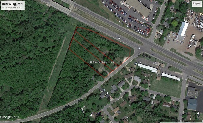
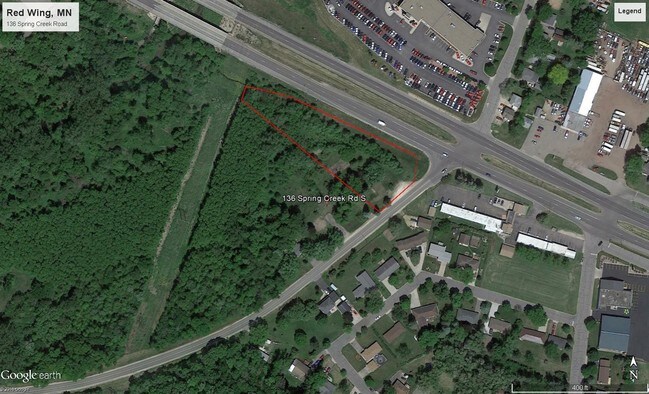
Property Record
53 Spring St, Kenyon, MN 55946
This Property Is For Sale
NEARBY LISTINGS FOR SALE OR LEASE
-
-
View all Kenyon listings for sale on LoopNet.com
Property Detail
53 Spring St
Other Market Areas
A S 23,26,27 113 15
Red Wing, MN
SECT-27 TWP-113 RANGE-015 A S 23,26,27 113 15 .38 AC PT OF NE1/4 SEC 27 113 15 SEE DOC #304714 RECORDED 6/2/86 DOC #691334
55.835.1041
Goodhue
Commercialnec
Minnesota
2025
0.38 AC
2025
Minnesota South Area
080700
DEMOGRAPHICS near 53 Spring St
1 Mile
3 Mile
5 Mile
2024 Total Population
2,231
8,968
19,599
2029 Population
2,341
9,258
20,084
Pop Growth 2024-2029
+ 4.93%
+ 3.23%
+ 2.47%
Average Age
44
44
43
2024 Total Households
957
3,962
8,381
HH Growth 2024-2029
+ 5.02%
+ 3.18%
+ 2.45%
Median Household Inc
$86,057
$65,199
$65,799
Avg Household Size
2.30
2.20
2.30
2024 Avg HH Vehicles
2.00
2.00
2.00
Median Home Value
$257,581
$228,759
$221,923
Median Year Built
1993
1978
1972
Nearby Places
Map Layers
Map Styles
 Street
 Aerial
- Restaurants
- Banks
- Shops
- Fitness
- Groceries
PUBLIC TRANSPORTATION
COMMUTER RAIL
Red Wing Amtrak Station (Empire Builder - Amtrak)
DRIVE
WALK
Distance
Red Wing Amtrak Station (Empire Builder - Amtrak)
5 min
3.1 mi
Freight Ports
Port Milwaukee
DRIVE
WALK
Distance
Port Milwaukee
342 min
300.2 mi
Nearby Properties
Address
Land Use
TOTAL SIZE
Lot Size
Zoning
Address
Land Use
TOTAL SIZE
Lot Size
Zoning
194,165 SF
24.87 AC
Address
Land Use
TOTAL SIZE
Lot Size
Zoning
88,787 SF
19.15 AC
Address
Land Use
TOTAL SIZE
Lot Size
Zoning
136,318 SF
4.30 AC
Address
Land Use
TOTAL SIZE
Lot Size
Zoning
82,695 SF
13.84 AC
Address
Land Use
TOTAL SIZE
Lot Size
Zoning
192,379 SF
22.63 AC
Address
Land Use
TOTAL SIZE
Lot Size
Zoning
173,191 SF
17.94 AC
Address
Land Use
TOTAL SIZE
Lot Size
Zoning
102,896 SF
0.82 AC
Address
Land Use
TOTAL SIZE
Lot Size
Zoning
119,200 SF
3.45 AC
Address
Land Use
TOTAL SIZE
Lot Size
Zoning
111,223 SF
Address
Land Use
TOTAL SIZE
Lot Size
Zoning
193,336 SF
15.04 AC
Address
Land Use
TOTAL SIZE
Lot Size
Zoning
120,692 SF
21.92 AC
Address
Land Use
TOTAL SIZE
Lot Size
Zoning
172,140 SF
0.60 AC
Address
Land Use
TOTAL SIZE
Lot Size
Zoning
87,184 SF
4.96 AC
Address
Land Use
TOTAL SIZE
Lot Size
Zoning
205,520 SF
16.43 AC
Address
Land Use
TOTAL SIZE
Lot Size
Zoning
18,818 SF
7.91 AC
Address
Land Use
TOTAL SIZE
Lot Size
Zoning
68,142 SF
9.04 AC
Address
Land Use
TOTAL SIZE
Lot Size
Zoning
223,377 SF
0.39 AC
Address
Land Use
TOTAL SIZE
Lot Size
Zoning
77,616 SF
100 AC
Address
Land Use
TOTAL SIZE
Lot Size
Zoning
1,800 SF
4.50 AC
Address
Land Use
TOTAL SIZE
Lot Size
Zoning
58,552 SF
2.21 AC
Address
Land Use
TOTAL SIZE
Lot Size
Zoning
1,824 SF
3.87 AC
Address
Land Use
TOTAL SIZE
Lot Size
Zoning
51,952 SF
2.96 AC
Address
Land Use
TOTAL SIZE
Lot Size
Zoning
62,100 SF
4.03 AC
Address
Land Use
TOTAL SIZE
Lot Size
Zoning
112,288 SF
0.49 AC
Address
Land Use
TOTAL SIZE
Lot Size
Zoning
52,602 SF
9.91 AC
Address
Land Use
TOTAL SIZE
Lot Size
Zoning
81,892 SF
1.05 AC
Address
Land Use
TOTAL SIZE
Lot Size
Zoning
23,580 SF
0.49 AC
Address
Land Use
TOTAL SIZE
Lot Size
Zoning
78,107 SF
0.74 AC
The World's #1 Commercial Real Estate Marketplace
Connect with us
© 2026 CoStar Group
The information above has been obtained from sources believed reliable. While we do not doubt its accuracy we have not verified it and make no guarantee, warranty or representation about it. It is your responsibility to independently confirm its accuracy and completeness. Any projections, opinions, assumptions, or estimates used are for example only and do not represent the current or future performance of the property. The value of this transaction to you depends on tax and other factors which should be evaluated by your tax, financial, and legal advisors. You and your advisors should conduct a careful, independent investigation of the property to determine to your satisfaction the suitability of the property for your needs.