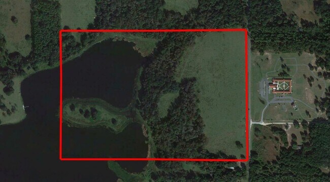
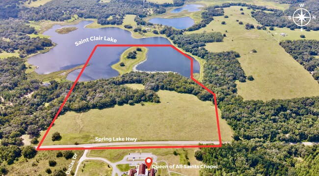
Property Record
Spring Lake Hwy, Brooksville, FL 34602

Save to a Folder
{{folder.Name}}
{{folder.ListingIds.length}} Properties
{{folder.ListingIds.length}} Property
Create a New Folder
Property Detail
Spring Lake Hwy
Tampa-St. Petersburg-Clearwater, FL
N1/2 OF NE1/4 & N3/8 OF S1/2 OF NE1/4 LESS A TR 1034X328X789X690X592X1603 FT MOL AS DES IN ORB 4383 PG 295 ORB 845 PGS 1589-1595 ORB 893 PGS 84-90
R33-423-20-0000-0020-0000
HERNANDO
Marshland
Florida
AE The base floodplain where base flood elevations are provided. AE Zones are now used on new format FIRMs instead of A1-A30 Zones.
68.10 AC
2025
Hernando County
2025
Tampa/St Petersburg
040301
NEARBY LISTINGS FOR SALE OR LEASE
DEMOGRAPHICS near Spring Lake Hwy
1 mile
3 mile
5 mile
2025 Total Population
212
1,955
6,868
2030 Population
228
2,135
7,600
Pop Growth 2025-2030
+ 7.55%
+ 9.21%
+ 10.66%
Average Age
47
46
45
2025 Total Households
87
787
2,707
HH Growth 2025-2030
+ 8.05%
+ 8.64%
+ 10.16%
Median Household Inc
$82,143
$85,937
$87,579
Avg Household Size
2.40
2.50
2.50
2025 Avg HH Vehicles
2.00
2.00
2.00
Median Home Value
$492,307
$485,472
$474,435
Median Year Built
1994
1994
1993
Nearby Places
Map Layers
Map Styles
 Street
 Aerial
Layers
 Traffic
 Biking
Places
Listings with unknown addresses are not visible on the map
- Restaurants
- Banks
- Shops
- Fitness
- Groceries
SALE & LEASE HISTORY
LISTING DATE
SALE/LEASE

Nov 30, 2023
For Sale
Feb 15, 2018
For Sale
Nearby Properties
Address
Land Use
TOTAL SIZE
Lot Size
Zoning
Address
Land Use
TOTAL SIZE
Lot Size
Zoning
45,644 SF
60.90 AC
Address
Land Use
TOTAL SIZE
Lot Size
Zoning
17,595 SF
99.30 AC
Address
Land Use
TOTAL SIZE
Lot Size
Zoning
15,777 SF
4.30 AC
Address
Land Use
TOTAL SIZE
Lot Size
Zoning
30,849 SF
39 AC
Address
Land Use
TOTAL SIZE
Lot Size
Zoning
25,088 SF
25 AC
Address
Land Use
TOTAL SIZE
Lot Size
Zoning
13,051 SF
3 AC
Address
Land Use
TOTAL SIZE
Lot Size
Zoning
12,149 SF
3 AC
Address
Land Use
TOTAL SIZE
Lot Size
Zoning
9,238 SF
17.60 AC
Address
Land Use
TOTAL SIZE
Lot Size
Zoning
7,691 SF
133 AC
R1
Address
Land Use
TOTAL SIZE
Lot Size
Zoning
6,861 SF
2.30 AC
Address
Land Use
TOTAL SIZE
Lot Size
Zoning
307.10 AC
AC
Address
Land Use
TOTAL SIZE
Lot Size
Zoning
11,881 SF
25.65 AC
AC
Address
Land Use
TOTAL SIZE
Lot Size
Zoning
7,887 SF
13 AC
Address
Land Use
TOTAL SIZE
Lot Size
Zoning
1,296 SF
22.10 AC
Address
Land Use
TOTAL SIZE
Lot Size
Zoning
6,198 SF
0.40 AC
Address
Land Use
TOTAL SIZE
Lot Size
Zoning
13,129 SF
10 AC
AC
Address
Land Use
TOTAL SIZE
Lot Size
Zoning
10,180 SF
10.80 AC
Address
Land Use
TOTAL SIZE
Lot Size
Zoning
13,521 SF
46.90 AC
Address
Land Use
TOTAL SIZE
Lot Size
Zoning
6,472 SF
11.90 AC
Address
Land Use
TOTAL SIZE
Lot Size
Zoning
8,204 SF
2 AC
Address
Land Use
TOTAL SIZE
Lot Size
Zoning
9,332 SF
20.15 AC
AC
Address
Land Use
TOTAL SIZE
Lot Size
Zoning
9,183 SF
1.50 AC
Address
Land Use
TOTAL SIZE
Lot Size
Zoning
6,828 SF
19.40 AC
Address
Land Use
TOTAL SIZE
Lot Size
Zoning
10,153 SF
38.57 AC
AC
Address
Land Use
TOTAL SIZE
Lot Size
Zoning
5,039 SF
1 AC
Address
Land Use
TOTAL SIZE
Lot Size
Zoning
5,664 SF
20.21 AC
AR
Address
Land Use
TOTAL SIZE
Lot Size
Zoning
5,394 SF
43 AC
Address
Land Use
TOTAL SIZE
Lot Size
Zoning
3,181 SF
40.69 AC
AC
Address
Land Use
TOTAL SIZE
Lot Size
Zoning
7,723 SF
59.51 AC
AC
Address
Land Use
TOTAL SIZE
Lot Size
Zoning
5,424 SF
8 AC
The World's #1 Commercial Real Estate Marketplace
Connect with us
© 2026 CoStar Group
The information above has been obtained from sources believed reliable. While we do not doubt its accuracy we have not verified it and make no guarantee, warranty or representation about it. It is your responsibility to independently confirm its accuracy and completeness. Any projections, opinions, assumptions, or estimates used are for example only and do not represent the current or future performance of the property. The value of this transaction to you depends on tax and other factors which should be evaluated by your tax, financial, and legal advisors. You and your advisors should conduct a careful, independent investigation of the property to determine to your satisfaction the suitability of the property for your needs.