Property Record
Springfield Rd, Danville, VA 24541

This Property Is For Sale
NEARBY LISTINGS FOR SALE OR LEASE
Property Detail
Springfield Rd
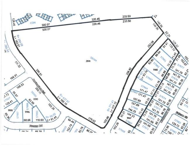
58394
APPROX 11.92 AC SPRINGFIELD RD & LOMBARDY WAY
Vacantlandnec
Danville City
X
Virginia
51143C0519E
11.92 AC
2025
Virginia South Central
2025
Other Market Areas
000800
Danville, VA
DEMOGRAPHICS near Springfield Rd
1 Mile
3 Mile
5 Mile
2024 Total Population
3,449
23,231
45,444
2029 Population
3,331
23,017
45,105
Pop Growth 2024-2029
(3.42%)
(0.92%)
(0.75%)
Average Age
44
42
43
2024 Total Households
1,531
10,149
19,863
HH Growth 2024-2029
(3.46%)
(1.00%)
(0.75%)
Median Household Inc
$51,818
$41,822
$45,344
Avg Household Size
2.10
2.20
2.20
2024 Avg HH Vehicles
2.00
2.00
2.00
Median Home Value
$121,957
$108,299
$143,369
Median Year Built
1968
1965
1966
Nearby Places
Map Layers
Map Styles
 Street
 Aerial
- Restaurants
- Banks
- Shops
- Fitness
- Groceries
PUBLIC TRANSPORTATION
COMMUTER RAIL
Danville Amtrak Station (Crescent - Amtrak)
DRIVE
WALK
Distance
Danville Amtrak Station (Crescent - Amtrak)
7 min
4.0 mi
Freight Ports
Virginia Port Authority - Richmond
DRIVE
WALK
Distance
Virginia Port Authority - Richmond
189 min
143.5 mi
Nearby Properties
Address
Land Use
TOTAL SIZE
Lot Size
Zoning
Address
Land Use
TOTAL SIZE
Lot Size
Zoning
12.20 AC
B-2
Address
Land Use
TOTAL SIZE
Lot Size
Zoning
508,832 SF
10.86 AC
TOBACCO WA
Address
Land Use
TOTAL SIZE
Lot Size
Zoning
93,230 SF
40.74 AC
TRANSITION
Address
Land Use
TOTAL SIZE
Lot Size
Zoning
35,736 SF
11.34 AC
MULTI-FAMI
Address
Land Use
TOTAL SIZE
Lot Size
Zoning
23.30 AC
M-1
Address
Land Use
TOTAL SIZE
Lot Size
Zoning
77,952 SF
16.59 AC
TRANSITION
Address
Land Use
TOTAL SIZE
Lot Size
Zoning
48,285 SF
3.76 AC
TOBACCO WA
Address
Land Use
TOTAL SIZE
Lot Size
Zoning
833,039 SF
66.18 AC
MANUFACTUR
Address
Land Use
TOTAL SIZE
Lot Size
Zoning
312,528 SF
23.32 AC
M-1
Address
Land Use
TOTAL SIZE
Lot Size
Zoning
102,314 SF
1.17 AC
TOBACCO WA
Address
Land Use
TOTAL SIZE
Lot Size
Zoning
41,664 SF
1.56 AC
TOBACCO WA
Address
Land Use
TOTAL SIZE
Lot Size
Zoning
154,823 SF
1.90 AC
TOBACCO WA
Address
Land Use
TOTAL SIZE
Lot Size
Zoning
2,516 SF
19.75 AC
DZ
Address
Land Use
TOTAL SIZE
Lot Size
Zoning
75,816 SF
7.04 AC
COND MULTI
Address
Land Use
TOTAL SIZE
Lot Size
Zoning
87,704 SF
1.70 AC
TOBACCO WA
Address
Land Use
TOTAL SIZE
Lot Size
Zoning
160,199 SF
15.90 AC
PLANNED SH
Address
Land Use
TOTAL SIZE
Lot Size
Zoning
59,791 SF
11.18 AC
HIGHWAY RE
Address
Land Use
TOTAL SIZE
Lot Size
Zoning
55,006 SF
4.49 AC
HIGHWAY RE
Address
Land Use
TOTAL SIZE
Lot Size
Zoning
106,836 SF
11.67 AC
OVERLAY PL
Address
Land Use
TOTAL SIZE
Lot Size
Zoning
380,043 SF
9.40 AC
OVERLAY PL
Address
Land Use
TOTAL SIZE
Lot Size
Zoning
25.05 AC
M-2
Address
Land Use
TOTAL SIZE
Lot Size
Zoning
37,213 SF
0.35 AC
CENTRAL BU
Address
Land Use
TOTAL SIZE
Lot Size
Zoning
26,593 SF
15.64 AC
MULTI-FAMI
Address
Land Use
TOTAL SIZE
Lot Size
Zoning
61,546 SF
4.98 AC
HIGHWAY RE
Address
Land Use
TOTAL SIZE
Lot Size
Zoning
60,590 SF
5.30 AC
OLD TOWN R
Address
Land Use
TOTAL SIZE
Lot Size
Zoning
37,137 SF
22.24 AC
MULTI-FAMI
Address
Land Use
TOTAL SIZE
Lot Size
Zoning
125,360 SF
0.54 AC
CENTRAL BU
Address
Land Use
TOTAL SIZE
Lot Size
Zoning
60,375 SF
0.45 AC
TOBACCO WA
Address
Land Use
TOTAL SIZE
Lot Size
Zoning
7,796 SF
8.43 AC
MULTI-FAMI
Address
Land Use
TOTAL SIZE
Lot Size
Zoning
96,366 SF
0.85 AC
TOBACCO WA
The World's #1 Commercial Real Estate Marketplace
Connect with us
© 2025 CoStar Group
The information above has been obtained from sources believed reliable. While we do not doubt its accuracy we have not verified it and make no guarantee, warranty or representation about it. It is your responsibility to independently confirm its accuracy and completeness. Any projections, opinions, assumptions, or estimates used are for example only and do not represent the current or future performance of the property. The value of this transaction to you depends on tax and other factors which should be evaluated by your tax, financial, and legal advisors. You and your advisors should conduct a careful, independent investigation of the property to determine to your satisfaction the suitability of the property for your needs.