Property Record
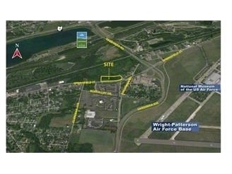
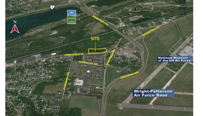
Springfield St, Riverside, OH 45431

Property Detail
Springfield St
Dayton, OH
7-2-23/24
I39-00104-0009
MONTGOMERY
Commercialacreage
Ohio
AH Areas with a 1% annual chance of shallow flooding, usually in the form of a pond, withan average depth ranging from 1 to 3 feet. These areas have a 26% chance of flooding over the life of a 30-year mortgage.
9
2024
2.92 AC
2025
East Dayton
210102
Cincinnati/Dayton
NEARBY LISTINGS FOR SALE OR LEASE
-
-
-
-
-
-
No Photo
-
View all Riverside listings for sale on LoopNet.com
DEMOGRAPHICS near Springfield St
1 mile
3 mile
5 mile
2025 Total Population
4,077
68,644
197,579
2030 Population
4,109
69,453
201,106
Pop Growth 2025-2030
+ 0.78%
+ 1.18%
+ 1.79%
Average Age
35
37
38
2025 Total Households
1,889
28,344
82,352
HH Growth 2025-2030
+ 0.58%
+ 1.20%
+ 1.85%
Median Household Inc
$45,419
$53,485
$56,349
Avg Household Size
2.10
2.30
2.20
2025 Avg HH Vehicles
1.00
2.00
2.00
Median Home Value
$104,124
$138,271
$159,796
Median Year Built
1964
1958
1959
Nearby Places
Map Layers
Map Styles
 Street
 Aerial
Layers
 Traffic
 Biking
Places
Listings with unknown addresses are not visible on the map
- Restaurants
- Banks
- Shops
- Fitness
- Groceries
PUBLIC TRANSPORTATION
AIRPORT
James M Cox Dayton International
Drive
Walk
Distance
James M Cox Dayton International
24 min
14.9 mi
SALE & LEASE HISTORY
LISTING DATE
SALE/LEASE

Sep 24, 2016
For Sale
Nearby Properties
Address
Land Use
TOTAL SIZE
Lot Size
Zoning
Address
Land Use
TOTAL SIZE
Lot Size
Zoning
154,360 SF
19.35 AC
Address
Land Use
TOTAL SIZE
Lot Size
Zoning
316.77 AC
Address
Land Use
TOTAL SIZE
Lot Size
Zoning
5.42 AC
Address
Land Use
TOTAL SIZE
Lot Size
Zoning
33,504 SF
14 AC
Address
Land Use
TOTAL SIZE
Lot Size
Zoning
133.37 AC
Address
Land Use
TOTAL SIZE
Lot Size
Zoning
46,796 SF
53.05 AC
RPUD038
Address
Land Use
TOTAL SIZE
Lot Size
Zoning
54.85 AC
Address
Land Use
TOTAL SIZE
Lot Size
Zoning
46.32 AC
Address
Land Use
TOTAL SIZE
Lot Size
Zoning
32.30 AC
Address
Land Use
TOTAL SIZE
Lot Size
Zoning
2,376 SF
18.75 AC
PD1
Address
Land Use
TOTAL SIZE
Lot Size
Zoning
18,087 SF
19.69 AC
Address
Land Use
TOTAL SIZE
Lot Size
Zoning
96,732 SF
6.73 AC
CPUD002
Address
Land Use
TOTAL SIZE
Lot Size
Zoning
94,608 SF
7.44 AC
Address
Land Use
TOTAL SIZE
Lot Size
Zoning
1,572 SF
5.25 AC
RPUD063
Address
Land Use
TOTAL SIZE
Lot Size
Zoning
634,508 SF
24.36 AC
Address
Land Use
TOTAL SIZE
Lot Size
Zoning
9,216 SF
16.77 AC
RPUD891
Address
Land Use
TOTAL SIZE
Lot Size
Zoning
23.20 AC
Address
Land Use
TOTAL SIZE
Lot Size
Zoning
1,200 SF
4.25 AC
B3
Address
Land Use
TOTAL SIZE
Lot Size
Zoning
Address
Land Use
TOTAL SIZE
Lot Size
Zoning
22.70 AC
Address
Land Use
TOTAL SIZE
Lot Size
Zoning
89,082 SF
4.61 AC
Address
Land Use
TOTAL SIZE
Lot Size
Zoning
101,262 SF
10.83 AC
Address
Land Use
TOTAL SIZE
Lot Size
Zoning
19,008 SF
19.96 AC
PD1
Address
Land Use
TOTAL SIZE
Lot Size
Zoning
10.47 AC
Address
Land Use
TOTAL SIZE
Lot Size
Zoning
9,840 SF
8.83 AC
PD1
Address
Land Use
TOTAL SIZE
Lot Size
Zoning
11.58 AC
Address
Land Use
TOTAL SIZE
Lot Size
Zoning
Address
Land Use
TOTAL SIZE
Lot Size
Zoning
8.98 AC
Address
Land Use
TOTAL SIZE
Lot Size
Zoning
203,730 SF
24.23 AC
CPUD904
Address
Land Use
TOTAL SIZE
Lot Size
Zoning
2,034 SF
23.83 AC
The World's #1 Commercial Real Estate Marketplace
Connect with us
© 2026 CoStar Group
The information above has been obtained from sources believed reliable. While we do not doubt its accuracy we have not verified it and make no guarantee, warranty or representation about it. It is your responsibility to independently confirm its accuracy and completeness. Any projections, opinions, assumptions, or estimates used are for example only and do not represent the current or future performance of the property. The value of this transaction to you depends on tax and other factors which should be evaluated by your tax, financial, and legal advisors. You and your advisors should conduct a careful, independent investigation of the property to determine to your satisfaction the suitability of the property for your needs.