Property Record
Spur 364, Spur, TX


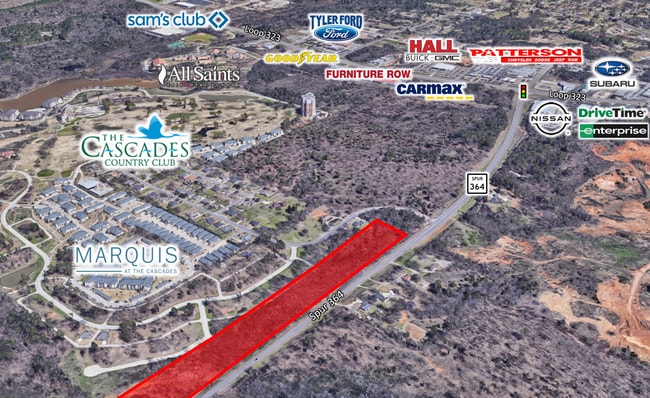
Property Detail
Spur 364
1-00000-0199-00-026000
ABST A0199 T COULTER TRACT 26 AC ADJ 2022
Agriculturalland
SMITH
PUR
Texas
A Areas with a 1% annual chance of flooding and a 26% chance of flooding over the life of a 30-year mortgage.
11.03 AC
2025
Tyler
2025
Other Market Areas
001602
Tyler, TX
NEARBY LISTINGS FOR SALE OR LEASE
DEMOGRAPHICS near Spur 364
1 mile
3 mile
5 mile
2025 Total Population
1,594
17,050
78,410
2030 Population
1,680
18,071
82,485
Pop Growth 2025-2030
+ 5.40%
+ 5.99%
+ 5.20%
Average Age
42
40
39
2025 Total Households
822
7,042
31,139
HH Growth 2025-2030
+ 4.50%
+ 5.41%
+ 4.62%
Median Household Inc
$81,660
$62,982
$64,394
Avg Household Size
1.90
2.30
2.40
2025 Avg HH Vehicles
2.00
2.00
2.00
Median Home Value
$415,384
$212,715
$250,555
Median Year Built
2005
1990
1979
Nearby Places
Map Layers
Map Styles
 Street
 Aerial
Layers
 Traffic
 Biking
Places
Listings with unknown addresses are not visible on the map
- Restaurants
- Banks
- Shops
- Fitness
- Groceries
PUBLIC TRANSPORTATION
AIRPORT
Tyler Pounds Regional
Drive
Walk
Distance
Tyler Pounds Regional
16 min
8.9 mi
Freight Ports
Port of Shreveport
Drive
Walk
Distance
Port of Shreveport
129 min
113.7 mi
SALE & LEASE HISTORY
LISTING DATE
SALE/LEASE

May 19, 2021
For Sale
Nearby Properties
Address
Land Use
TOTAL SIZE
Lot Size
Zoning
Address
Land Use
TOTAL SIZE
Lot Size
Zoning
278 SF
22.07 AC
PMF
Address
Land Use
TOTAL SIZE
Lot Size
Zoning
24.83 AC
Address
Land Use
TOTAL SIZE
Lot Size
Zoning
29.58 AC
Address
Land Use
TOTAL SIZE
Lot Size
Zoning
39.16 AC
C2
Address
Land Use
TOTAL SIZE
Lot Size
Zoning
14,504 SF
16.68 AC
Address
Land Use
TOTAL SIZE
Lot Size
Zoning
5,068 SF
18.35 AC
RMF
Address
Land Use
TOTAL SIZE
Lot Size
Zoning
71,337 SF
15.70 AC
M1
Address
Land Use
TOTAL SIZE
Lot Size
Zoning
4,333 SF
13.32 AC
Address
Land Use
TOTAL SIZE
Lot Size
Zoning
2,774 SF
16.15 AC
RMF
Address
Land Use
TOTAL SIZE
Lot Size
Zoning
3,724 SF
33.26 AC
RMF
Address
Land Use
TOTAL SIZE
Lot Size
Zoning
53,412 SF
11.17 AC
PMF
Address
Land Use
TOTAL SIZE
Lot Size
Zoning
187.64 AC
R1A
Address
Land Use
TOTAL SIZE
Lot Size
Zoning
1,867 SF
13.63 AC
RMF
Address
Land Use
TOTAL SIZE
Lot Size
Zoning
126.94 AC
Address
Land Use
TOTAL SIZE
Lot Size
Zoning
90,410 SF
4.94 AC
Address
Land Use
TOTAL SIZE
Lot Size
Zoning
3,806 SF
18.86 AC
RMF
Address
Land Use
TOTAL SIZE
Lot Size
Zoning
3,477 SF
9.56 AC
RMF
Address
Land Use
TOTAL SIZE
Lot Size
Zoning
22.85 AC
Address
Land Use
TOTAL SIZE
Lot Size
Zoning
2,936 SF
9.66 AC
RMF
Address
Land Use
TOTAL SIZE
Lot Size
Zoning
4,478 SF
9.06 AC
RMF
Address
Land Use
TOTAL SIZE
Lot Size
Zoning
58,161 SF
7.02 AC
Address
Land Use
TOTAL SIZE
Lot Size
Zoning
34,758 SF
9.76 AC
Address
Land Use
TOTAL SIZE
Lot Size
Zoning
14.16 AC
Address
Land Use
TOTAL SIZE
Lot Size
Zoning
5 AC
R1B
Address
Land Use
TOTAL SIZE
Lot Size
Zoning
45,114 SF
30.60 AC
Address
Land Use
TOTAL SIZE
Lot Size
Zoning
80,070 SF
9.04 AC
Address
Land Use
TOTAL SIZE
Lot Size
Zoning
205,196 SF
25.19 AC
C2
Address
Land Use
TOTAL SIZE
Lot Size
Zoning
85,804 SF
8.69 AC
M1
Address
Land Use
TOTAL SIZE
Lot Size
Zoning
90,125 SF
20.75 AC
M1
Address
Land Use
TOTAL SIZE
Lot Size
Zoning
55,523 SF
11.04 AC
The World's #1 Commercial Real Estate Marketplace
Connect with us
© 2026 CoStar Group
The information above has been obtained from sources believed reliable. While we do not doubt its accuracy we have not verified it and make no guarantee, warranty or representation about it. It is your responsibility to independently confirm its accuracy and completeness. Any projections, opinions, assumptions, or estimates used are for example only and do not represent the current or future performance of the property. The value of this transaction to you depends on tax and other factors which should be evaluated by your tax, financial, and legal advisors. You and your advisors should conduct a careful, independent investigation of the property to determine to your satisfaction the suitability of the property for your needs.