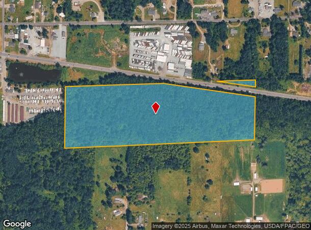
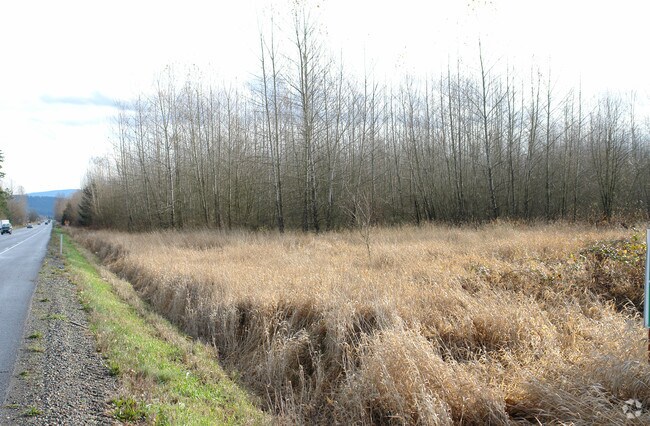
Property Record
Sr410 E Sr410 E, Buckley, WA 98321


NEARBY LISTINGS FOR SALE OR LEASE
Property Detail
Sr410 E Sr410 E
061905-3504
STR: S2NE4SW4&SE4NW4SW4 S05T19NR06E WM
Residentialacreage
Pierce
X
Washington
53033C1515G
28.38 AC
2024
E Pierce County
2025
Seattle/Puget Sound
070205
Seattle-Tacoma-Bellevue, WA
DEMOGRAPHICS near Sr410 E Sr410 E
1 Mile
3 Mile
5 Mile
2024 Total Population
763
14,276
52,356
2029 Population
760
14,606
53,792
Pop Growth 2024-2029
(0.39%)
+ 2.31%
+ 2.74%
Average Age
42
40
39
2024 Total Households
277
5,043
18,519
HH Growth 2024-2029
(0.36%)
+ 2.24%
+ 2.65%
Median Household Inc
$106,071
$115,869
$109,691
Avg Household Size
2.70
2.80
2.80
2024 Avg HH Vehicles
3.00
3.00
3.00
Median Home Value
$499,999
$496,189
$490,545
Median Year Built
1991
1990
1991
Nearby Places
Map Layers
Map Styles
 Street
 Aerial
- Restaurants
- Banks
- Shops
- Fitness
- Groceries
PUBLIC TRANSPORTATION
AIRPORT
Seattle-Tacoma International
DRIVE
WALK
Distance
Seattle-Tacoma International
48 min
30.7 mi
Freight Ports
Port of Tacoma
DRIVE
WALK
Distance
Port of Tacoma
31 min
19.8 mi
SALE & LEASE HISTORY
LISTING DATE
SALE/LEASE

Sep 24, 2016
For Sale
Mar 27, 2017
For Sale
Nearby Properties
Address
Land Use
TOTAL SIZE
Lot Size
Zoning
Address
Land Use
TOTAL SIZE
Lot Size
Zoning
331,876 SF
14.41 AC
Address
Land Use
TOTAL SIZE
Lot Size
Zoning
230,000 SF
54.30 AC
R10
Address
Land Use
TOTAL SIZE
Lot Size
Zoning
240,262 SF
47.07 AC
P
Address
Land Use
TOTAL SIZE
Lot Size
Zoning
184,250 SF
10.33 AC
Address
Land Use
TOTAL SIZE
Lot Size
Zoning
151,202 SF
7.94 AC
CG
Address
Land Use
TOTAL SIZE
Lot Size
Zoning
132,260 SF
2.09 AC
Address
Land Use
TOTAL SIZE
Lot Size
Zoning
87,458 SF
5.10 AC
Address
Land Use
TOTAL SIZE
Lot Size
Zoning
2 SF
10.93 AC
NO DATA
Address
Land Use
TOTAL SIZE
Lot Size
Zoning
55,635 SF
1.96 AC
E
Address
Land Use
TOTAL SIZE
Lot Size
Zoning
46,446 SF
4.73 AC
C2
Address
Land Use
TOTAL SIZE
Lot Size
Zoning
45,102 SF
19.53 AC
R10
Address
Land Use
TOTAL SIZE
Lot Size
Zoning
47,992 SF
3.49 AC
NMU
Address
Land Use
TOTAL SIZE
Lot Size
Zoning
64,530 SF
19.91 AC
R10
Address
Land Use
TOTAL SIZE
Lot Size
Zoning
79,848 SF
5.99 AC
LI
Address
Land Use
TOTAL SIZE
Lot Size
Zoning
48,905 SF
12.26 AC
R10
Address
Land Use
TOTAL SIZE
Lot Size
Zoning
32,500 SF
8.18 AC
E
Address
Land Use
TOTAL SIZE
Lot Size
Zoning
44,013 SF
3.57 AC
CG
Address
Land Use
TOTAL SIZE
Lot Size
Zoning
27,727 SF
9.25 AC
NMU
Address
Land Use
TOTAL SIZE
Lot Size
Zoning
24,041 SF
5.68 AC
R10
Address
Land Use
TOTAL SIZE
Lot Size
Zoning
38,000 SF
2.60 AC
LI
Address
Land Use
TOTAL SIZE
Lot Size
Zoning
38,000 SF
2.62 AC
LI
Address
Land Use
TOTAL SIZE
Lot Size
Zoning
30,692 SF
4.58 AC
P
Address
Land Use
TOTAL SIZE
Lot Size
Zoning
20,373 SF
3.65 AC
BUCK
Address
Land Use
TOTAL SIZE
Lot Size
Zoning
23,223 SF
1.76 AC
BLK
Address
Land Use
TOTAL SIZE
Lot Size
Zoning
16,060 SF
5.01 AC
R-6,000
Address
Land Use
TOTAL SIZE
Lot Size
Zoning
21,504 SF
1.40 AC
HDR
Address
Land Use
TOTAL SIZE
Lot Size
Zoning
10.41 AC
Address
Land Use
TOTAL SIZE
Lot Size
Zoning
10.21 AC
Address
Land Use
TOTAL SIZE
Lot Size
Zoning
40,000 SF
4.02 AC
LI
Address
Land Use
TOTAL SIZE
Lot Size
Zoning
19,960 SF
2.84 AC
E
The World's #1 Commercial Real Estate Marketplace
Connect with us
© 2026 CoStar Group
The information above has been obtained from sources believed reliable. While we do not doubt its accuracy we have not verified it and make no guarantee, warranty or representation about it. It is your responsibility to independently confirm its accuracy and completeness. Any projections, opinions, assumptions, or estimates used are for example only and do not represent the current or future performance of the property. The value of this transaction to you depends on tax and other factors which should be evaluated by your tax, financial, and legal advisors. You and your advisors should conduct a careful, independent investigation of the property to determine to your satisfaction the suitability of the property for your needs.