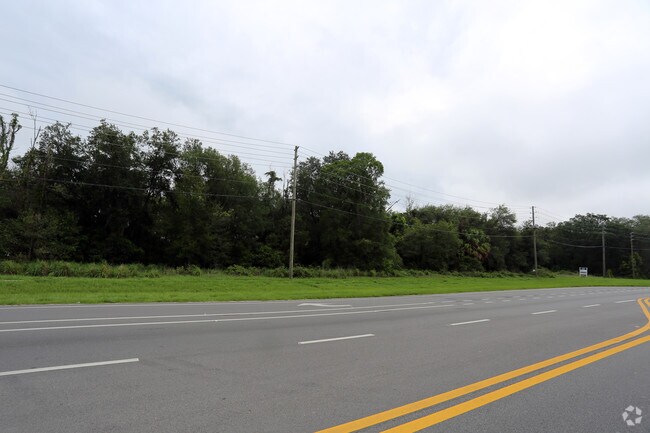
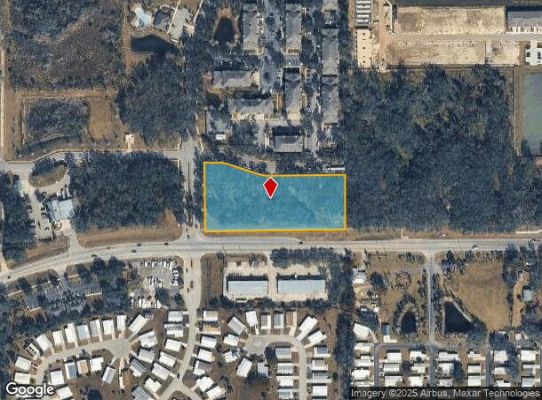
Property Record
35943 State Road 54, Zephyrhills, FL 33541
NEARBY LISTINGS FOR SALE OR LEASE
Property Detail
35943 State Road 54
Tampa-St. Petersburg-Clearwater, FL
Zephyr Ridge
08-26-21-0000-00200-0000
PARCEL LYING IN SE1/4 OF SE1/4 OF SEC 8 LYING NORTH OF R/W SR 54 & ELY & SLY OF PROPOSED R/W PER OR 7118 PG 1765 & SUBJECT TO UTILITY EASEMENT PER OR 7506 PG 1887 SUBJECT TO EASEMENT AGREEMENT PER OR 7917 PG 1588 & EXCEPT PORTION PUT INTO ZEPHYR RIDG
Commercialacreage
Pasco
X
Florida
12101C0451F
2.82 AC
2024
Pasco County
2025
Tampa/St Petersburg
032901
DEMOGRAPHICS near 35943 State Road 54
1 Mile
3 Mile
5 Mile
2024 Total Population
8,237
51,427
90,559
2029 Population
9,958
62,835
111,030
Pop Growth 2024-2029
+ 20.89%
+ 22.18%
+ 22.61%
Average Age
51
48
46
2024 Total Households
3,856
22,708
38,091
HH Growth 2024-2029
+ 21.08%
+ 22.16%
+ 22.47%
Median Household Inc
$44,337
$44,762
$51,609
Avg Household Size
2.10
2.20
2.30
2024 Avg HH Vehicles
1.00
2.00
2.00
Median Home Value
$94,533
$129,150
$169,473
Median Year Built
1987
1988
1991
Nearby Places
- Restaurants
- Banks
- Shops
- Fitness
- Groceries
PUBLIC TRANSPORTATION
AIRPORT
Tampa International
DRIVE
WALK
Distance
Tampa International
53 min
38.2 mi
Freight Ports
Port of Tampa Bay
DRIVE
WALK
Distance
Port of Tampa Bay
49 min
33.9 mi
SALE & LEASE HISTORY
LISTING DATE
SALE/LEASE

Sep 24, 2016
For Sale
May 01, 2019
For Sale
Nearby Properties
Address
Land Use
TOTAL SIZE
Lot Size
Zoning
Address
Land Use
TOTAL SIZE
Lot Size
Zoning
277,779 SF
18.93 AC
MPUD
Address
Land Use
TOTAL SIZE
Lot Size
Zoning
253,292 SF
22.26 AC
MPUD
Address
Land Use
TOTAL SIZE
Lot Size
Zoning
309,662 SF
59.03 AC
MF1
Address
Land Use
TOTAL SIZE
Lot Size
Zoning
252,942 SF
13.59 AC
MPUD
Address
Land Use
TOTAL SIZE
Lot Size
Zoning
245,602 SF
12.57 AC
MPUD
Address
Land Use
TOTAL SIZE
Lot Size
Zoning
199,367 SF
15.46 AC
R2
Address
Land Use
TOTAL SIZE
Lot Size
Zoning
129,416 SF
3.87 AC
C2
Address
Land Use
TOTAL SIZE
Lot Size
Zoning
292,589 SF
52.57 AC
R3
Address
Land Use
TOTAL SIZE
Lot Size
Zoning
33.29 AC
MPUD
Address
Land Use
TOTAL SIZE
Lot Size
Zoning
93,395 SF
6.71 AC
MPUD
Address
Land Use
TOTAL SIZE
Lot Size
Zoning
91,192 SF
3.40 AC
C2
Address
Land Use
TOTAL SIZE
Lot Size
Zoning
11,189 SF
34.32 AC
C2
Address
Land Use
TOTAL SIZE
Lot Size
Zoning
68,446 SF
3.54 AC
C2
Address
Land Use
TOTAL SIZE
Lot Size
Zoning
82,605 SF
37.03 AC
AR
Address
Land Use
TOTAL SIZE
Lot Size
Zoning
69,405 SF
2.15 AC
MPUD
Address
Land Use
TOTAL SIZE
Lot Size
Zoning
101.06 AC
MPUD
Address
Land Use
TOTAL SIZE
Lot Size
Zoning
60,759 SF
7.56 AC
C2
Address
Land Use
TOTAL SIZE
Lot Size
Zoning
104,720 SF
13.22 AC
C2
Address
Land Use
TOTAL SIZE
Lot Size
Zoning
32,076 SF
3.58 AC
PUD
Address
Land Use
TOTAL SIZE
Lot Size
Zoning
64,769 SF
11.78 AC
C2
Address
Land Use
TOTAL SIZE
Lot Size
Zoning
209.20 AC
MPUD
Address
Land Use
TOTAL SIZE
Lot Size
Zoning
107,022 SF
13.27 AC
C2
Address
Land Use
TOTAL SIZE
Lot Size
Zoning
76,015 SF
9.18 AC
C2
Address
Land Use
TOTAL SIZE
Lot Size
Zoning
61,636 SF
6.84 AC
C2
Address
Land Use
TOTAL SIZE
Lot Size
Zoning
38,397 SF
7.18 AC
C2
Address
Land Use
TOTAL SIZE
Lot Size
Zoning
131,274 SF
13.07 AC
R4
Address
Land Use
TOTAL SIZE
Lot Size
Zoning
27 AC
AC
Address
Land Use
TOTAL SIZE
Lot Size
Zoning
72,183 SF
42.44 AC
R3
Address
Land Use
TOTAL SIZE
Lot Size
Zoning
67,222 SF
7.96 AC
C2
Address
Land Use
TOTAL SIZE
Lot Size
Zoning
58,090 SF
5.30 AC
MF1
The World's #1 Commercial Real Estate Marketplace
Connect with us
© 2025 CoStar Group
The information above has been obtained from sources believed reliable. While we do not doubt its accuracy we have not verified it and make no guarantee, warranty or representation about it. It is your responsibility to independently confirm its accuracy and completeness. Any projections, opinions, assumptions, or estimates used are for example only and do not represent the current or future performance of the property. The value of this transaction to you depends on tax and other factors which should be evaluated by your tax, financial, and legal advisors. You and your advisors should conduct a careful, independent investigation of the property to determine to your satisfaction the suitability of the property for your needs.