Property Record
Sr1648 Us 74 Byp, Laurinburg, NC 28352

NEARBY LISTINGS FOR SALE OR LEASE
-
-
View all Laurinburg listings for sale on LoopNet.com
Property Detail
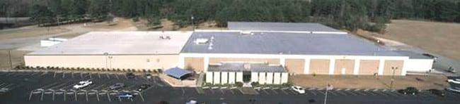
Sr1648 Us 74 Byp
01-0245-01-071
FROM DICKERSON GROUP
Warehouse
Scotland
X
North Carolina
3710837600K
12.22 AC
2025
North Carolina Southeast Area
2025
Other Market Areas
010102
Laurinburg, NC
109,201 SF
DEMOGRAPHICS near Sr1648 Us 74 Byp
1 Mile
3 Mile
5 Mile
2024 Total Population
438
12,137
20,151
2029 Population
440
12,194
20,165
Pop Growth 2024-2029
+ 0.46%
+ 0.47%
+ 0.07%
Average Age
37
40
41
2024 Total Households
118
4,472
7,338
HH Growth 2024-2029
+ 0.85%
+ 0.56%
+ 0.11%
Median Household Inc
$37,999
$25,884
$32,706
Avg Household Size
2.50
2.30
2.30
2024 Avg HH Vehicles
2.00
1.00
2.00
Median Home Value
$92,707
$86,468
$107,256
Median Year Built
1981
1971
1975
Nearby Places
Map Layers
Map Styles
 Street
 Aerial
- Restaurants
- Banks
- Shops
- Fitness
- Groceries
PUBLIC TRANSPORTATION
AIRPORT
Fayetteville Regional/Grannis Field
DRIVE
WALK
Distance
Fayetteville Regional/Grannis Field
61 min
41.1 mi
Nearby Properties
Address
Land Use
TOTAL SIZE
Lot Size
Zoning
Address
Land Use
TOTAL SIZE
Lot Size
Zoning
61,000 SF
43.43 AC
OI
Address
Land Use
TOTAL SIZE
Lot Size
Zoning
114,260 SF
29.90 AC
OI
Address
Land Use
TOTAL SIZE
Lot Size
Zoning
62,578 SF
2.41 AC
OI
Address
Land Use
TOTAL SIZE
Lot Size
Zoning
13,148 SF
8.45 AC
R6
Address
Land Use
TOTAL SIZE
Lot Size
Zoning
11,010 SF
424 AC
I2
Address
Land Use
TOTAL SIZE
Lot Size
Zoning
53,774 SF
9.58 AC
OI
Address
Land Use
TOTAL SIZE
Lot Size
Zoning
39,654 SF
0.64 AC
CB
Address
Land Use
TOTAL SIZE
Lot Size
Zoning
92,385 SF
13.77 AC
GB
Address
Land Use
TOTAL SIZE
Lot Size
Zoning
11,088 SF
10.60 AC
R6
Address
Land Use
TOTAL SIZE
Lot Size
Zoning
55,316 SF
1.01 AC
OI
Address
Land Use
TOTAL SIZE
Lot Size
Zoning
7,548 SF
93.10 AC
I2
Address
Land Use
TOTAL SIZE
Lot Size
Zoning
33,046 SF
3.75 AC
OI
Address
Land Use
TOTAL SIZE
Lot Size
Zoning
86,156 SF
9.50 AC
GB
Address
Land Use
TOTAL SIZE
Lot Size
Zoning
36,820 SF
1.71 AC
GB
Address
Land Use
TOTAL SIZE
Lot Size
Zoning
14,752 SF
4.31 AC
OI
Address
Land Use
TOTAL SIZE
Lot Size
Zoning
11,824 SF
59.60 AC
I
Address
Land Use
TOTAL SIZE
Lot Size
Zoning
33,708 SF
7.26 AC
GB
Address
Land Use
TOTAL SIZE
Lot Size
Zoning
1,465 SF
10 AC
R6
Address
Land Use
TOTAL SIZE
Lot Size
Zoning
4,900 SF
14.05 AC
OI
Address
Land Use
TOTAL SIZE
Lot Size
Zoning
37,592 SF
14.99 AC
OI
Address
Land Use
TOTAL SIZE
Lot Size
Zoning
26,502 SF
5.83 AC
OI
Address
Land Use
TOTAL SIZE
Lot Size
Zoning
17,960 SF
9.81 AC
OI
Address
Land Use
TOTAL SIZE
Lot Size
Zoning
37,345 SF
0.78 AC
OI
Address
Land Use
TOTAL SIZE
Lot Size
Zoning
48,235 SF
6.14 AC
GB
Address
Land Use
TOTAL SIZE
Lot Size
Zoning
24,553 SF
4.20 AC
OI
Address
Land Use
TOTAL SIZE
Lot Size
Zoning
2,525 SF
6.42 AC
R6
Address
Land Use
TOTAL SIZE
Lot Size
Zoning
1,562 SF
6.50 AC
R6
Address
Land Use
TOTAL SIZE
Lot Size
Zoning
26,558 SF
1.82 AC
GB
Address
Land Use
TOTAL SIZE
Lot Size
Zoning
7,607 SF
7.76 AC
OI
Address
Land Use
TOTAL SIZE
Lot Size
Zoning
16,576 SF
1.91 AC
GB
The World's #1 Commercial Real Estate Marketplace
Connect with us
© 2026 CoStar Group
The information above has been obtained from sources believed reliable. While we do not doubt its accuracy we have not verified it and make no guarantee, warranty or representation about it. It is your responsibility to independently confirm its accuracy and completeness. Any projections, opinions, assumptions, or estimates used are for example only and do not represent the current or future performance of the property. The value of this transaction to you depends on tax and other factors which should be evaluated by your tax, financial, and legal advisors. You and your advisors should conduct a careful, independent investigation of the property to determine to your satisfaction the suitability of the property for your needs.