Property Record
Sr200 A1a Ln, Yulee, FL 32097


Save to a Folder
{{folder.Name}}
{{folder.ListingIds.length}} Properties
{{folder.ListingIds.length}} Property
Create a New Folder
This Property Is For Sale
Property Detail
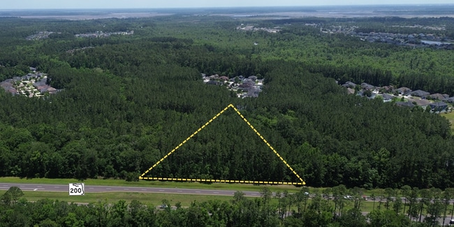
Sr200 A1a Ln
Jacksonville, FL
PAR 1-12 IN SEC 12 & 8-1 IN SEC 1 & 1-1 IN SEC 11 & 2-4 IN SEC 13 IN OR 1832/874 (EX PAR 2 2-1 2-2 & EX ESMT PT OR 1601/667 & EX PLUMMER CREEK PBK 8/28 EX 1-13 & 1-14 & EX PT R/W CASE #2001-CA-467 & CNSVTN ESMTS PT OR 1845/1125 & PT OR 1854/728 & EX
12-2N-26-0000-0001-0120
NASSAU
Marshland
Florida
PUD
1
A Areas with a 1% annual chance of flooding and a 26% chance of flooding over the life of a 30-year mortgage.
185.03 AC
2025
Nassau County
2025
Jacksonville (Florida)
050304
NEARBY LISTINGS FOR SALE OR LEASE
DEMOGRAPHICS near Sr200 A1a Ln
1 mile
3 mile
5 mile
2025 Total Population
2,212
8,993
14,041
2030 Population
2,566
10,598
16,392
Pop Growth 2025-2030
+ 16.00%
+ 17.85%
+ 16.74%
Average Age
35
36
37
2025 Total Households
693
2,781
4,433
HH Growth 2025-2030
+ 16.16%
+ 17.69%
+ 16.54%
Median Household Inc
$111,979
$111,846
$108,357
Avg Household Size
3.20
3.00
2.90
2025 Avg HH Vehicles
2.00
2.00
2.00
Median Home Value
$419,455
$376,103
$348,968
Median Year Built
2017
2018
2016
Nearby Places
Map Layers
Map Styles
 Street
 Aerial
Layers
 Traffic
 Biking
Places
Listings with unknown addresses are not visible on the map
- Restaurants
- Banks
- Shops
- Fitness
- Groceries
PUBLIC TRANSPORTATION
AIRPORT
Jacksonville International
Drive
Walk
Distance
Jacksonville International
23 min
14.5 mi
Freight Ports
Jacksonville Port
Drive
Walk
Distance
Jacksonville Port
33 min
23.9 mi
Nearby Properties
Address
Land Use
TOTAL SIZE
Lot Size
Zoning
Address
Land Use
TOTAL SIZE
Lot Size
Zoning
249,913 SF
160.04 AC
OR
Address
Land Use
TOTAL SIZE
Lot Size
Zoning
306,222 SF
21.65 AC
PD - ENCPA
Address
Land Use
TOTAL SIZE
Lot Size
Zoning
291,580 SF
12.56 AC
PD - ENCPA
Address
Land Use
TOTAL SIZE
Lot Size
Zoning
223,389 SF
25.75 AC
RG-1
Address
Land Use
TOTAL SIZE
Lot Size
Zoning
302,387 SF
29.60 AC
PD - ENCPA
Address
Land Use
TOTAL SIZE
Lot Size
Zoning
134,139 SF
27.49 AC
PD - ENCPA
Address
Land Use
TOTAL SIZE
Lot Size
Zoning
91,196 SF
86.52 AC
OR
Address
Land Use
TOTAL SIZE
Lot Size
Zoning
83,799 SF
13.18 AC
PD - ENCPA
Address
Land Use
TOTAL SIZE
Lot Size
Zoning
42,189 SF
7.69 AC
PD - ENCPA
Address
Land Use
TOTAL SIZE
Lot Size
Zoning
11,151 SF
55.27 AC
CI
Address
Land Use
TOTAL SIZE
Lot Size
Zoning
23,934 SF
20.45 AC
CN
Address
Land Use
TOTAL SIZE
Lot Size
Zoning
13,472 SF
Address
Land Use
TOTAL SIZE
Lot Size
Zoning
81,960 SF
2.90 AC
PD - ENCPA
Address
Land Use
TOTAL SIZE
Lot Size
Zoning
104,064 SF
5.27 AC
CHT
Address
Land Use
TOTAL SIZE
Lot Size
Zoning
38,211 SF
5.54 AC
PD - ENCPA
Address
Land Use
TOTAL SIZE
Lot Size
Zoning
12,594 SF
Address
Land Use
TOTAL SIZE
Lot Size
Zoning
25,920 SF
14.72 AC
GPU
Address
Land Use
TOTAL SIZE
Lot Size
Zoning
41,762 SF
1.93 AC
CHT
Address
Land Use
TOTAL SIZE
Lot Size
Zoning
33,733 SF
2.78 AC
CHT
Address
Land Use
TOTAL SIZE
Lot Size
Zoning
16,518 SF
23.33 AC
PD - ENCPA
Address
Land Use
TOTAL SIZE
Lot Size
Zoning
18,276 SF
1.57 AC
PD - ENCPA
Address
Land Use
TOTAL SIZE
Lot Size
Zoning
29,862 SF
1.68 AC
CHT
Address
Land Use
TOTAL SIZE
Lot Size
Zoning
6,285 SF
Address
Land Use
TOTAL SIZE
Lot Size
Zoning
25.03 AC
CHT
Address
Land Use
TOTAL SIZE
Lot Size
Zoning
11,598 SF
1.03 AC
PD - ENCPA
Address
Land Use
TOTAL SIZE
Lot Size
Zoning
7.40 AC
CHT
Address
Land Use
TOTAL SIZE
Lot Size
Zoning
10.44 AC
Address
Land Use
TOTAL SIZE
Lot Size
Zoning
529.22 AC
PUD
Address
Land Use
TOTAL SIZE
Lot Size
Zoning
3,768 SF
11.95 AC
CHT
Address
Land Use
TOTAL SIZE
Lot Size
Zoning
8,857 SF
1.18 AC
PD - ENCPA
The World's #1 Commercial Real Estate Marketplace
Connect with us
© 2026 CoStar Group
The information above has been obtained from sources believed reliable. While we do not doubt its accuracy we have not verified it and make no guarantee, warranty or representation about it. It is your responsibility to independently confirm its accuracy and completeness. Any projections, opinions, assumptions, or estimates used are for example only and do not represent the current or future performance of the property. The value of this transaction to you depends on tax and other factors which should be evaluated by your tax, financial, and legal advisors. You and your advisors should conduct a careful, independent investigation of the property to determine to your satisfaction the suitability of the property for your needs.