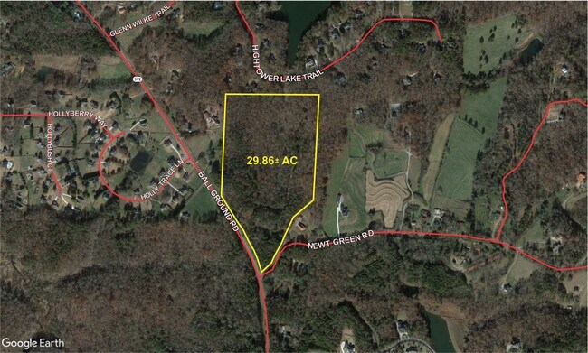
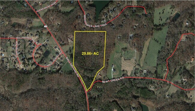
Property Record
Sr372 S R 372 Hwy # R 372, Ball Ground, GA 30107
NEARBY LISTINGS FOR SALE OR LEASE
Property Detail
Sr372 S R 372 Hwy # R 372
003N22-00000-160-000-0000
LL 750-651 3RD D
Agriculturalland
Cherokee
X
Georgia
13117C0020F
750
2025
11.88 AC
2025
Cherokee County
090507
Atlanta
2,656 SF
Atlanta-Sandy Springs-Roswell, GA
DEMOGRAPHICS near Sr372 S R 372 Hwy # R 372
1 Mile
3 Mile
5 Mile
2024 Total Population
715
8,207
34,841
2029 Population
812
9,455
40,287
Pop Growth 2024-2029
+ 13.57%
+ 15.21%
+ 15.63%
Average Age
44
42
41
2024 Total Households
254
2,852
11,611
HH Growth 2024-2029
+ 13.78%
+ 15.22%
+ 15.66%
Median Household Inc
$153,365
$115,031
$122,215
Avg Household Size
2.80
2.80
2.90
2024 Avg HH Vehicles
3.00
3.00
2.00
Median Home Value
$562,000
$481,375
$460,881
Median Year Built
1988
1996
2002
Nearby Places
Map Layers
Map Styles
 Street
 Aerial
- Restaurants
- Banks
- Shops
- Fitness
- Groceries
SALE & LEASE HISTORY
LISTING DATE
SALE/LEASE

Nov 08, 2023
For Sale
Jul 31, 2024
For Sale
Jan 30, 2025
For Sale
Dec 01, 2023
For Sale
Nearby Properties
Address
Land Use
TOTAL SIZE
Lot Size
Zoning
Address
Land Use
TOTAL SIZE
Lot Size
Zoning
9,785 SF
202.45 AC
MULTI
Address
Land Use
TOTAL SIZE
Lot Size
Zoning
108,303 SF
39.38 AC
AG
Address
Land Use
TOTAL SIZE
Lot Size
Zoning
68,520 SF
12.35 AC
GC
Address
Land Use
TOTAL SIZE
Lot Size
Zoning
8,696 SF
24.23 AC
OI
Address
Land Use
TOTAL SIZE
Lot Size
Zoning
28,914 SF
277.46 AC
PUD
Address
Land Use
TOTAL SIZE
Lot Size
Zoning
9,858 SF
18.06 AC
A1
Address
Land Use
TOTAL SIZE
Lot Size
Zoning
198.63 AC
AG
Address
Land Use
TOTAL SIZE
Lot Size
Zoning
44,470 SF
40.56 AC
AG
Address
Land Use
TOTAL SIZE
Lot Size
Zoning
254.28 AC
AG
Address
Land Use
TOTAL SIZE
Lot Size
Zoning
74.15 AC
AG
Address
Land Use
TOTAL SIZE
Lot Size
Zoning
33,508 SF
6.43 AC
R-40
Address
Land Use
TOTAL SIZE
Lot Size
Zoning
60 AC
AG
Address
Land Use
TOTAL SIZE
Lot Size
Zoning
538.36 AC
AG
Address
Land Use
TOTAL SIZE
Lot Size
Zoning
46,157 SF
4.11 AC
LI
Address
Land Use
TOTAL SIZE
Lot Size
Zoning
108.88 AC
AG
Address
Land Use
TOTAL SIZE
Lot Size
Zoning
3,916 SF
282.63 AC
AG
Address
Land Use
TOTAL SIZE
Lot Size
Zoning
18,600 SF
4.24 AC
GC
Address
Land Use
TOTAL SIZE
Lot Size
Zoning
1,232 SF
149.53 AC
AG
Address
Land Use
TOTAL SIZE
Lot Size
Zoning
123.32 AC
A1
Address
Land Use
TOTAL SIZE
Lot Size
Zoning
91.56 AC
AG
Address
Land Use
TOTAL SIZE
Lot Size
Zoning
147.45 AC
AG
Address
Land Use
TOTAL SIZE
Lot Size
Zoning
151 AC
AG
Address
Land Use
TOTAL SIZE
Lot Size
Zoning
14,992 SF
12.51 AC
HB
Address
Land Use
TOTAL SIZE
Lot Size
Zoning
3,907 SF
54.52 AC
A1
Address
Land Use
TOTAL SIZE
Lot Size
Zoning
2,400 SF
178.56 AC
AG
Address
Land Use
TOTAL SIZE
Lot Size
Zoning
2,298 SF
14.17 AC
M1
Address
Land Use
TOTAL SIZE
Lot Size
Zoning
12,201 SF
3.51 AC
AG
Address
Land Use
TOTAL SIZE
Lot Size
Zoning
58.58 AC
AG
Address
Land Use
TOTAL SIZE
Lot Size
Zoning
3,724 SF
36.94 AC
A1
Address
Land Use
TOTAL SIZE
Lot Size
Zoning
63.55 AC
AG
The World's #1 Commercial Real Estate Marketplace
Connect with us
© 2025 CoStar Group
The information above has been obtained from sources believed reliable. While we do not doubt its accuracy we have not verified it and make no guarantee, warranty or representation about it. It is your responsibility to independently confirm its accuracy and completeness. Any projections, opinions, assumptions, or estimates used are for example only and do not represent the current or future performance of the property. The value of this transaction to you depends on tax and other factors which should be evaluated by your tax, financial, and legal advisors. You and your advisors should conduct a careful, independent investigation of the property to determine to your satisfaction the suitability of the property for your needs.