Property Record
Sr38 E Sr 38 E, Dayton, IN 47941


Save to a Folder
{{folder.Name}}
{{folder.ListingIds.length}} Properties
{{folder.ListingIds.length}} Property
Create a New Folder
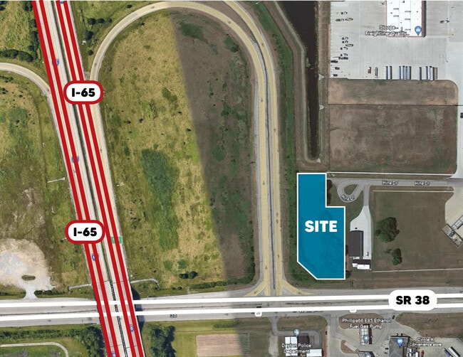
This Property Is For Sale
Property Detail
Sr38 E Sr 38 E
Lafayette-West Lafayette, IN
PT W SE SEC 5 TWP 22 R3 0.65 A & PT E SW SEC 5 TWP 22 R3 1.11 A PER SURVEY
79-12-05-451-001.000-013
TIPPECANOE
Commercialacreage
Indiana
HB
1
B and X Area of moderate flood hazard, usually the area between the limits of the 100-year and 500-year floods.
1.76 AC
2024
Lafayette/Kokomo
2025
Other Market Areas
010902
NEARBY LISTINGS FOR SALE OR LEASE
DEMOGRAPHICS near Sr38 E Sr 38 E
1 mile
3 mile
5 mile
2025 Total Population
989
7,430
36,919
2030 Population
957
7,456
37,068
Pop Growth 2025-2030
(3.24%)
+ 0.35%
+ 0.40%
Average Age
40
39
38
2025 Total Households
381
2,927
15,039
HH Growth 2025-2030
(3.15%)
+ 0.34%
+ 0.45%
Median Household Inc
$60,726
$78,083
$70,393
Avg Household Size
2.60
2.50
2.40
2025 Avg HH Vehicles
2.00
2.00
2.00
Median Home Value
$223,287
$262,880
$252,741
Median Year Built
1993
1998
1991
Nearby Places
Map Layers
Map Styles
 Street
 Aerial
Layers
 Traffic
 Biking
Places
Listings with unknown addresses are not visible on the map
- Restaurants
- Banks
- Shops
- Fitness
- Groceries
PUBLIC TRANSPORTATION
COMMUTER RAIL
Lafayette Amtrak Station (Cardinal - Amtrak)
Drive
Walk
Distance
Lafayette Amtrak Station (Cardinal - Amtrak)
12 min
7.8 mi
Freight Ports
Port Milwaukee
Drive
Walk
Distance
Port Milwaukee
250 min
210.3 mi
Nearby Properties
Address
Land Use
TOTAL SIZE
Lot Size
Zoning
Address
Land Use
TOTAL SIZE
Lot Size
Zoning
2,199,963 SF
0.06 AC
Address
Land Use
TOTAL SIZE
Lot Size
Zoning
122,338 SF
0.01 AC
Address
Land Use
TOTAL SIZE
Lot Size
Zoning
507,320 SF
0.01 AC
Address
Land Use
TOTAL SIZE
Lot Size
Zoning
689,020 SF
0.01 AC
Address
Land Use
TOTAL SIZE
Lot Size
Zoning
298,339 SF
19.58 AC
R1
Address
Land Use
TOTAL SIZE
Lot Size
Zoning
117,351 SF
44 SF
Address
Land Use
TOTAL SIZE
Lot Size
Zoning
298,050 SF
50.91 AC
Address
Land Use
TOTAL SIZE
Lot Size
Zoning
356,549 SF
45.62 AC
I3
Address
Land Use
TOTAL SIZE
Lot Size
Zoning
316,008 SF
27.04 AC
Address
Land Use
TOTAL SIZE
Lot Size
Zoning
263,826 SF
174 SF
Address
Land Use
TOTAL SIZE
Lot Size
Zoning
294,840 SF
23.01 AC
I3
Address
Land Use
TOTAL SIZE
Lot Size
Zoning
500,000 SF
174 SF
Address
Land Use
TOTAL SIZE
Lot Size
Zoning
160,572 SF
19.25 AC
Address
Land Use
TOTAL SIZE
Lot Size
Zoning
154,040 SF
44 SF
Address
Land Use
TOTAL SIZE
Lot Size
Zoning
175,000 SF
11.61 AC
Address
Land Use
TOTAL SIZE
Lot Size
Zoning
68,404 SF
0.88 AC
MR
Address
Land Use
TOTAL SIZE
Lot Size
Zoning
134,360 SF
6.90 AC
Address
Land Use
TOTAL SIZE
Lot Size
Zoning
152,835 SF
10.04 AC
Address
Land Use
TOTAL SIZE
Lot Size
Zoning
117,000 SF
44 SF
Address
Land Use
TOTAL SIZE
Lot Size
Zoning
175,740 SF
15.66 AC
I3
Address
Land Use
TOTAL SIZE
Lot Size
Zoning
102,786 SF
12.94 AC
Address
Land Use
TOTAL SIZE
Lot Size
Zoning
39,204 SF
2.05 AC
Address
Land Use
TOTAL SIZE
Lot Size
Zoning
54,935 SF
131 SF
Address
Land Use
TOTAL SIZE
Lot Size
Zoning
120,000 SF
44 SF
Address
Land Use
TOTAL SIZE
Lot Size
Zoning
46,574 SF
62.56 AC
Address
Land Use
TOTAL SIZE
Lot Size
Zoning
68,600 SF
12.20 AC
I3
Address
Land Use
TOTAL SIZE
Lot Size
Zoning
36,926 SF
0.01 AC
Address
Land Use
TOTAL SIZE
Lot Size
Zoning
20,832 SF
87 SF
Address
Land Use
TOTAL SIZE
Lot Size
Zoning
72,870 SF
4.41 AC
Address
Land Use
TOTAL SIZE
Lot Size
Zoning
54,000 SF
12.16 AC
I3
The World's #1 Commercial Real Estate Marketplace
Connect with us
© 2026 CoStar Group
The information above has been obtained from sources believed reliable. While we do not doubt its accuracy we have not verified it and make no guarantee, warranty or representation about it. It is your responsibility to independently confirm its accuracy and completeness. Any projections, opinions, assumptions, or estimates used are for example only and do not represent the current or future performance of the property. The value of this transaction to you depends on tax and other factors which should be evaluated by your tax, financial, and legal advisors. You and your advisors should conduct a careful, independent investigation of the property to determine to your satisfaction the suitability of the property for your needs.