Property Record
Sr64 E Sr 64 E, Bradenton, FL 34208


Property Detail
Sr64 E Sr 64 E
11224-0000-3
COM AT CONC MON, MARKING THE SE COR OF SEC 27, TWN 34S, RNG 18E; TH N 89 DEG 30 MIN 46 SEC W, ALG S LN OF SD SEC 27, 1378.00 FT TO THE SW COR OF THAT CERTAIN PARCEL OF LAND AS
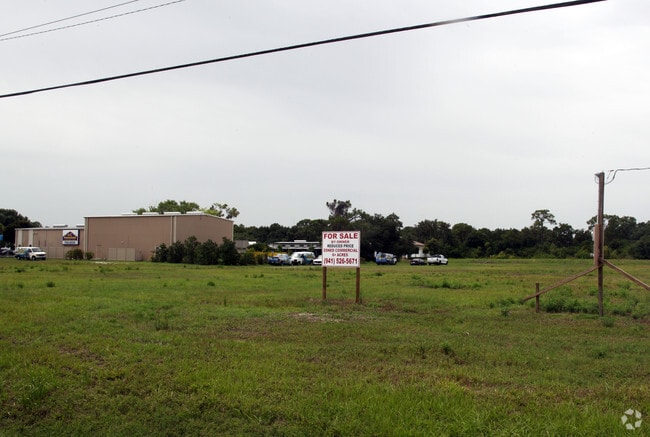
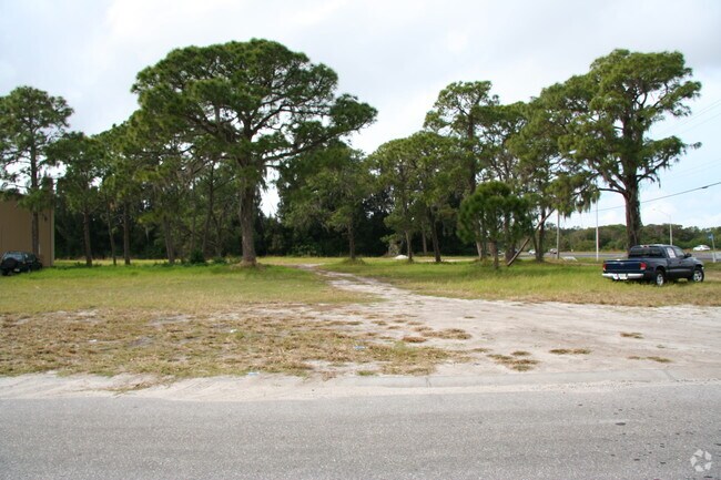
Commercialacreage
MANATEE
GC GENERA
Florida
B and X Area of moderate flood hazard, usually the area between the limits of the 100-year and 500-year floods.
2.96 AC
2024
Manatee
2024
Tampa/St Petersburg
000705
North Port-Bradenton-Sarasota, FL
NEARBY LISTINGS FOR SALE OR LEASE
DEMOGRAPHICS near Sr64 E Sr 64 E
1 mile
3 mile
5 mile
2024 Total Population
5,985
37,034
143,319
2029 Population
6,686
41,446
160,764
Pop Growth 2024-2029
+ 11.71%
+ 11.91%
+ 12.17%
Average Age
39
47
46
2024 Total Households
2,551
16,306
58,689
HH Growth 2024-2029
+ 11.84%
+ 12.09%
+ 12.48%
Median Household Inc
$76,232
$88,249
$84,758
Avg Household Size
2.30
2.20
2.40
2024 Avg HH Vehicles
2.00
2.00
2.00
Median Home Value
$362,781
$446,408
$426,624
Median Year Built
2005
2001
2002
Nearby Places
Map Layers
Map Styles
 Street
 Aerial
Transit
 Traffic
 Biking
Places
Listings with unknown addresses are not visible on the map
- Restaurants
- Banks
- Shops
- Fitness
- Groceries
PUBLIC TRANSPORTATION
AIRPORT
Sarasota/Bradenton International
Drive
Walk
Distance
Sarasota/Bradenton International
24 min
16.0 mi
Freight Ports
Port Manatee
Drive
Walk
Distance
Port Manatee
22 min
14.3 mi
Nearby Properties
Address
Land Use
TOTAL SIZE
Lot Size
Zoning
Address
Land Use
TOTAL SIZE
Lot Size
Zoning
881,490 SF
83.09 AC
BR_R-3
Address
Land Use
TOTAL SIZE
Lot Size
Zoning
513,465 SF
78.39 AC
PD-MU
Address
Land Use
TOTAL SIZE
Lot Size
Zoning
707,409 SF
27.98 AC
PD-MU
Address
Land Use
TOTAL SIZE
Lot Size
Zoning
319,679 SF
31.78 AC
BR_R-1
Address
Land Use
TOTAL SIZE
Lot Size
Zoning
311,669 SF
34.55 AC
BR_R-2
Address
Land Use
TOTAL SIZE
Lot Size
Zoning
293,332 SF
50.52 AC
A-1 SUBURB
Address
Land Use
TOTAL SIZE
Lot Size
Zoning
225,768 SF
18.47 AC
BR_R-1
Address
Land Use
TOTAL SIZE
Lot Size
Zoning
89,137 SF
11.61 AC
Address
Land Use
TOTAL SIZE
Lot Size
Zoning
348,901 SF
27 AC
BR_R-2
Address
Land Use
TOTAL SIZE
Lot Size
Zoning
29,566 SF
1.17 AC
PD-PI
Address
Land Use
TOTAL SIZE
Lot Size
Zoning
160,163 SF
16.35 AC
PD-MU
Address
Land Use
TOTAL SIZE
Lot Size
Zoning
107,298 SF
12.91 AC
PD-MU
Address
Land Use
TOTAL SIZE
Lot Size
Zoning
10,389 SF
57.58 AC
PD-RV
Address
Land Use
TOTAL SIZE
Lot Size
Zoning
310,215 SF
134.06 AC
A GENERAL
Address
Land Use
TOTAL SIZE
Lot Size
Zoning
220,706 SF
24.13 AC
PD-C, A-1
Address
Land Use
TOTAL SIZE
Lot Size
Zoning
234,818 SF
18.20 AC
BR_R-2
Address
Land Use
TOTAL SIZE
Lot Size
Zoning
201,982 SF
16.65 AC
BR_SCC
Address
Land Use
TOTAL SIZE
Lot Size
Zoning
13,621 SF
61.72 AC
PD-RV,RSF-
Address
Land Use
TOTAL SIZE
Lot Size
Zoning
92,466 SF
18.80 AC
A-1 SUBURB
Address
Land Use
TOTAL SIZE
Lot Size
Zoning
61,770 SF
79.85 AC
A,A-1
Address
Land Use
TOTAL SIZE
Lot Size
Zoning
151,596 SF
29.79 AC
BR_PDP
Address
Land Use
TOTAL SIZE
Lot Size
Zoning
138,535 SF
13.94 AC
BR_SCC
Address
Land Use
TOTAL SIZE
Lot Size
Zoning
91,918 SF
6.03 AC
PD-C
Address
Land Use
TOTAL SIZE
Lot Size
Zoning
42,905 SF
6.17 AC
PD-C
Address
Land Use
TOTAL SIZE
Lot Size
Zoning
63,563 SF
4.44 AC
Address
Land Use
TOTAL SIZE
Lot Size
Zoning
59,222 SF
4.49 AC
PD-C
Address
Land Use
TOTAL SIZE
Lot Size
Zoning
65,761 SF
11.91 AC
BR_SCC
Address
Land Use
TOTAL SIZE
Lot Size
Zoning
47,241 SF
15.63 AC
A-1 SUBURB
Address
Land Use
TOTAL SIZE
Lot Size
Zoning
56,246 SF
8.06 AC
BR_SCC
Address
Land Use
TOTAL SIZE
Lot Size
Zoning
35,784 SF
6.26 AC
PD-MU
The World's #1 Commercial Real Estate Marketplace
Connect with us
© 2026 CoStar Group
The information above has been obtained from sources believed reliable. While we do not doubt its accuracy we have not verified it and make no guarantee, warranty or representation about it. It is your responsibility to independently confirm its accuracy and completeness. Any projections, opinions, assumptions, or estimates used are for example only and do not represent the current or future performance of the property. The value of this transaction to you depends on tax and other factors which should be evaluated by your tax, financial, and legal advisors. You and your advisors should conduct a careful, independent investigation of the property to determine to your satisfaction the suitability of the property for your needs.