Property Record
Sr87 Rd, Eloy, AZ 85131


Property Detail
Sr87 Rd
Phoenix-Mesa-Chandler, AZ
THAT PORTION OF NW NW SEC 15-08S-08E LYING WEST OF THE WESTERLY L INE OF THE SPRR; THEN SOUTH AND EAST OF THE FOLLOWING DESCRIBED LINE: COM @ THE NW COR SEC 15-08S-08E TH N88D E-531.47 TH S01D E- 50.00 TO POB TH CONT S01D E-25.00 TH S8D W-333.08 TH S
411-15-004C
PINAL
Vacantlandnec
Arizona
B and X Area of moderate flood hazard, usually the area between the limits of the 100-year and 500-year floods.
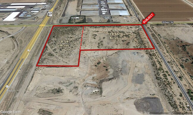
23.17 AC
2024
Pinal County
2025
Phoenix
NEARBY LISTINGS FOR SALE OR LEASE
DEMOGRAPHICS near Sr87 Rd
1 mile
3 mile
5 mile
2025 Total Population
20
4,155
7,320
2030 Population
24
4,896
8,628
Pop Growth 2025-2030
+ 20.00%
+ 17.83%
+ 17.87%
Average Age
40
36
36
2025 Total Households
7
1,353
2,314
HH Growth 2025-2030
+ 14.29%
+ 17.66%
+ 17.59%
Median Household Inc
$67,500
$45,600
$42,984
Avg Household Size
2.60
3.10
3.10
2025 Avg HH Vehicles
2.00
2.00
2.00
Median Home Value
$199,999
$135,646
$149,116
Median Year Built
1984
1983
1981
Nearby Places
Map Layers
Map Styles
 Street
 Aerial
Transit
 Traffic
 Biking
Places
Listings with unknown addresses are not visible on the map
- Restaurants
- Banks
- Shops
- Fitness
- Groceries
SALE & LEASE HISTORY
LISTING DATE
SALE/LEASE

Oct 15, 2018
For Sale
Nearby Properties
Address
Land Use
TOTAL SIZE
Lot Size
Zoning
Address
Land Use
TOTAL SIZE
Lot Size
Zoning
350,596 SF
27.45 AC
CI2
Address
Land Use
TOTAL SIZE
Lot Size
Zoning
17,880 SF
4.11 AC
UNDESIGNAT
Address
Land Use
TOTAL SIZE
Lot Size
Zoning
5,352 SF
31.28 AC
Address
Land Use
TOTAL SIZE
Lot Size
Zoning
19,209 SF
20 AC
UNDESIGNAT
Address
Land Use
TOTAL SIZE
Lot Size
Zoning
9,372 SF
73.06 AC
Address
Land Use
TOTAL SIZE
Lot Size
Zoning
5.97 AC
UNDESIGNAT
Address
Land Use
TOTAL SIZE
Lot Size
Zoning
11,950 SF
2.28 AC
UNDESIGNAT
Address
Land Use
TOTAL SIZE
Lot Size
Zoning
62,607 SF
13.87 AC
CI1
Address
Land Use
TOTAL SIZE
Lot Size
Zoning
17.79 AC
Address
Land Use
TOTAL SIZE
Lot Size
Zoning
11,852 SF
1.22 AC
Address
Land Use
TOTAL SIZE
Lot Size
Zoning
8,303 SF
0.69 AC
Address
Land Use
TOTAL SIZE
Lot Size
Zoning
14,008 SF
8.10 AC
UNDESIGNAT
Address
Land Use
TOTAL SIZE
Lot Size
Zoning
20,196 SF
80 AC
GR
Address
Land Use
TOTAL SIZE
Lot Size
Zoning
5,136 SF
0.13 AC
Address
Land Use
TOTAL SIZE
Lot Size
Zoning
7,200 SF
1.32 AC
UNDESIGNAT
Address
Land Use
TOTAL SIZE
Lot Size
Zoning
14.08 AC
Address
Land Use
TOTAL SIZE
Lot Size
Zoning
21,468 SF
1.73 AC
UNDESIGNAT
Address
Land Use
TOTAL SIZE
Lot Size
Zoning
15,244 SF
640 AC
Address
Land Use
TOTAL SIZE
Lot Size
Zoning
9,074 SF
0.98 AC
UNDESIGNAT
Address
Land Use
TOTAL SIZE
Lot Size
Zoning
9,311 SF
2.75 AC
UNDESIGNAT
Address
Land Use
TOTAL SIZE
Lot Size
Zoning
625 SF
4.48 AC
Address
Land Use
TOTAL SIZE
Lot Size
Zoning
6,776 SF
1.10 AC
Address
Land Use
TOTAL SIZE
Lot Size
Zoning
15,259 SF
0.86 AC
UNDESIGNAT
Address
Land Use
TOTAL SIZE
Lot Size
Zoning
8,505 SF
0.69 AC
UNDESIGNAT
Address
Land Use
TOTAL SIZE
Lot Size
Zoning
8,546 SF
1.67 AC
UNDESIGNAT
Address
Land Use
TOTAL SIZE
Lot Size
Zoning
7,848 SF
0.69 AC
UNDESIGNAT
Address
Land Use
TOTAL SIZE
Lot Size
Zoning
6,601 SF
1.29 AC
Address
Land Use
TOTAL SIZE
Lot Size
Zoning
4.95 AC
UNDESIGNAT
Address
Land Use
TOTAL SIZE
Lot Size
Zoning
308 AC
UNDESIGNAT
Address
Land Use
TOTAL SIZE
Lot Size
Zoning
9,195 SF
0.99 AC
The World's #1 Commercial Real Estate Marketplace
Connect with us
© 2026 CoStar Group
The information above has been obtained from sources believed reliable. While we do not doubt its accuracy we have not verified it and make no guarantee, warranty or representation about it. It is your responsibility to independently confirm its accuracy and completeness. Any projections, opinions, assumptions, or estimates used are for example only and do not represent the current or future performance of the property. The value of this transaction to you depends on tax and other factors which should be evaluated by your tax, financial, and legal advisors. You and your advisors should conduct a careful, independent investigation of the property to determine to your satisfaction the suitability of the property for your needs.