Property Record
6575 W Hash Knife Draw Rd, Queen Creek, AZ 85142
This Property Is For Sale
NEARBY LISTINGS FOR SALE OR LEASE
Property Detail
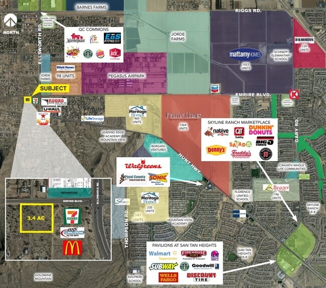
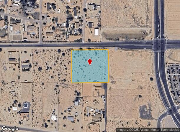
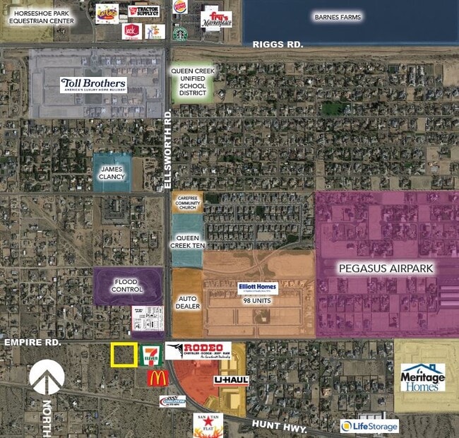
6575 W Hash Knife Draw Rd
Phoenix-Mesa-Scottsdale, AZ
San Tan Ranches
509-05-005
SAN TAN RANCHES #3 LOT 2
Residentialacreage
Pinal
X
Arizona
04013C3135L
2
2024
3.36 AC
2025
Pinal County
817200
Phoenix
DEMOGRAPHICS near 6575 W Hash Knife Draw Rd
1 Mile
3 Mile
5 Mile
2024 Total Population
2,231
48,392
136,574
2029 Population
2,547
57,982
162,547
Pop Growth 2024-2029
+ 14.16%
+ 19.82%
+ 19.02%
Average Age
38
35
36
2024 Total Households
669
14,640
42,194
HH Growth 2024-2029
+ 14.50%
+ 20.16%
+ 19.36%
Median Household Inc
$129,852
$100,899
$104,846
Avg Household Size
3.30
3.30
3.20
2024 Avg HH Vehicles
3.00
2.00
2.00
Median Home Value
$510,204
$377,011
$407,006
Median Year Built
2006
2009
2009
Nearby Places
- Restaurants
- Banks
- Shops
- Fitness
- Groceries
PUBLIC TRANSPORTATION
AIRPORT
Phoenix-Mesa Gateway
DRIVE
WALK
Distance
Phoenix-Mesa Gateway
15 min
8.3 mi
Phoenix Sky Harbor International
DRIVE
WALK
Distance
Phoenix Sky Harbor International
53 min
37.5 mi
Freight Ports
Port of San Diego
DRIVE
WALK
Distance
Port of San Diego
414 min
373.8 mi
Nearby Properties
Address
Land Use
TOTAL SIZE
Lot Size
Zoning
Address
Land Use
TOTAL SIZE
Lot Size
Zoning
92,153 SF
8.34 AC
GR
Address
Land Use
TOTAL SIZE
Lot Size
Zoning
32,858 SF
13.76 AC
C-G
Address
Land Use
TOTAL SIZE
Lot Size
Zoning
53,995 SF
10.12 AC
Address
Land Use
TOTAL SIZE
Lot Size
Zoning
250,050 SF
17.47 AC
Address
Land Use
TOTAL SIZE
Lot Size
Zoning
339,494 SF
48.27 AC
R-4
Address
Land Use
TOTAL SIZE
Lot Size
Zoning
30,624 SF
13.41 AC
Address
Land Use
TOTAL SIZE
Lot Size
Zoning
30,944 SF
7.03 AC
Address
Land Use
TOTAL SIZE
Lot Size
Zoning
64,499 SF
10 AC
Address
Land Use
TOTAL SIZE
Lot Size
Zoning
97,313 SF
5.69 AC
CB2
Address
Land Use
TOTAL SIZE
Lot Size
Zoning
20,053 SF
3.86 AC
R-43
Address
Land Use
TOTAL SIZE
Lot Size
Zoning
187,208 SF
34.75 AC
MDR
Address
Land Use
TOTAL SIZE
Lot Size
Zoning
Address
Land Use
TOTAL SIZE
Lot Size
Zoning
6.02 AC
I-1
Address
Land Use
TOTAL SIZE
Lot Size
Zoning
117,552 SF
30.35 AC
R143
Address
Land Use
TOTAL SIZE
Lot Size
Zoning
95,413 SF
11.30 AC
R-43
Address
Land Use
TOTAL SIZE
Lot Size
Zoning
Address
Land Use
TOTAL SIZE
Lot Size
Zoning
14,748 SF
1.92 AC
Address
Land Use
TOTAL SIZE
Lot Size
Zoning
182,360 SF
10.52 AC
M-H
Address
Land Use
TOTAL SIZE
Lot Size
Zoning
11,691 SF
3.61 AC
Address
Land Use
TOTAL SIZE
Lot Size
Zoning
63,033 SF
11.33 AC
R-C
Address
Land Use
TOTAL SIZE
Lot Size
Zoning
58,874 SF
13.78 AC
R-43
Address
Land Use
TOTAL SIZE
Lot Size
Zoning
10,200 SF
1.35 AC
Address
Land Use
TOTAL SIZE
Lot Size
Zoning
60,799 SF
6.14 AC
R15
Address
Land Use
TOTAL SIZE
Lot Size
Zoning
8,494 SF
1.53 AC
Address
Land Use
TOTAL SIZE
Lot Size
Zoning
8,590 SF
3.83 AC
Address
Land Use
TOTAL SIZE
Lot Size
Zoning
38,561 SF
4.14 AC
The World's #1 Commercial Real Estate Marketplace
Connect with us
© 2025 CoStar Group
The information above has been obtained from sources believed reliable. While we do not doubt its accuracy we have not verified it and make no guarantee, warranty or representation about it. It is your responsibility to independently confirm its accuracy and completeness. Any projections, opinions, assumptions, or estimates used are for example only and do not represent the current or future performance of the property. The value of this transaction to you depends on tax and other factors which should be evaluated by your tax, financial, and legal advisors. You and your advisors should conduct a careful, independent investigation of the property to determine to your satisfaction the suitability of the property for your needs.