Property Record
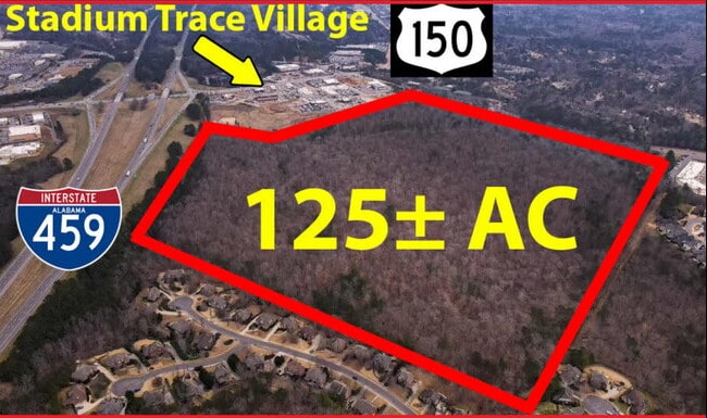
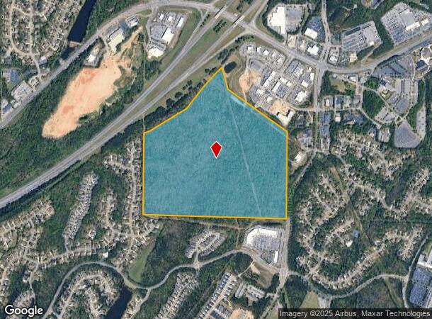
5300 Magnolia Trce, Hoover, AL 35244
NEARBY LISTINGS FOR SALE OR LEASE
Property Detail
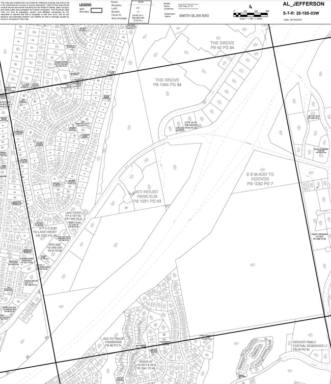
5300 Magnolia Trce
39-00-28-4-000-001.000
ALL THE SE 1/4 OF SEC 28 TP 19 R 3 EXC R/W FOR I-459 HWY & PT LYING NW OF SD HWY LESS AND EXCEPT THE FOLLOWINGBEG AT THE NE COR OF SE 1/4 OF SEC 28 TWN19S R3W THN S 1063 FT THN NW 1348FT TJM NW 307FT TH E 1180FT TH POB
Vacantlandnec
Jefferson
X
Alabama
01073C0701H
141 AC
2023
Hoover
2024
Birmingham
014410
Birmingham-Hoover, AL
DEMOGRAPHICS near 5300 Magnolia Trce
1 Mile
3 Mile
5 Mile
2024 Total Population
4,097
36,359
97,691
2029 Population
3,974
36,398
99,102
Pop Growth 2024-2029
(3.00%)
+ 0.11%
+ 1.44%
Average Age
40
41
39
2024 Total Households
1,611
13,870
38,337
HH Growth 2024-2029
(3.23%)
+ 0.13%
+ 1.25%
Median Household Inc
$108,777
$105,688
$88,912
Avg Household Size
2.50
2.60
2.50
2024 Avg HH Vehicles
2.00
2.00
2.00
Median Home Value
$396,301
$352,044
$298,396
Median Year Built
1997
1995
1992
Nearby Places
- Restaurants
- Banks
- Shops
- Fitness
- Groceries
PUBLIC TRANSPORTATION
AIRPORT
Birmingham-Shuttlesworth International
DRIVE
WALK
Distance
Birmingham-Shuttlesworth International
29 min
19.7 mi
Freight Ports
Port of Mobile
DRIVE
WALK
Distance
Port of Mobile
273 min
250.4 mi
Nearby Properties
Address
Land Use
TOTAL SIZE
Lot Size
Zoning
Address
Land Use
TOTAL SIZE
Lot Size
Zoning
333,513 SF
40.80 AC
C2
Address
Land Use
TOTAL SIZE
Lot Size
Zoning
582,638 SF
43.76 AC
PUDP
Address
Land Use
TOTAL SIZE
Lot Size
Zoning
69,151 SF
4.90 AC
PC
Address
Land Use
TOTAL SIZE
Lot Size
Zoning
186,953 SF
20 AC
PR2
Address
Land Use
TOTAL SIZE
Lot Size
Zoning
237,921 SF
6.35 AC
PUDP
Address
Land Use
TOTAL SIZE
Lot Size
Zoning
284,436 SF
40.98 AC
PUDP
Address
Land Use
TOTAL SIZE
Lot Size
Zoning
241,232 SF
15.01 AC
PR2
Address
Land Use
TOTAL SIZE
Lot Size
Zoning
165,474 SF
90 AC
PR2
Address
Land Use
TOTAL SIZE
Lot Size
Zoning
160,443 SF
23 AC
C-2
Address
Land Use
TOTAL SIZE
Lot Size
Zoning
238,304 SF
18.90 AC
PR-2
Address
Land Use
TOTAL SIZE
Lot Size
Zoning
200,679 SF
20 AC
PR2
Address
Land Use
TOTAL SIZE
Lot Size
Zoning
231,385 SF
50.40 AC
R6
Address
Land Use
TOTAL SIZE
Lot Size
Zoning
224,746 SF
46 AC
C2
Address
Land Use
TOTAL SIZE
Lot Size
Zoning
172,648 SF
39.45 AC
Address
Land Use
TOTAL SIZE
Lot Size
Zoning
22,726 SF
15.77 AC
Address
Land Use
TOTAL SIZE
Lot Size
Zoning
121,049 SF
9.10 AC
PR2
Address
Land Use
TOTAL SIZE
Lot Size
Zoning
185,856 SF
6.70 AC
PC
Address
Land Use
TOTAL SIZE
Lot Size
Zoning
152,735 SF
9.80 AC
R-4
Address
Land Use
TOTAL SIZE
Lot Size
Zoning
105,299 SF
25.50 AC
T3
Address
Land Use
TOTAL SIZE
Lot Size
Zoning
141,296 SF
14.51 AC
C2
Address
Land Use
TOTAL SIZE
Lot Size
Zoning
83,700 SF
60 AC
PC
Address
Land Use
TOTAL SIZE
Lot Size
Zoning
94,329 SF
15.60 AC
C1
Address
Land Use
TOTAL SIZE
Lot Size
Zoning
35,503 SF
2.92 AC
C2
Address
Land Use
TOTAL SIZE
Lot Size
Zoning
41,374 SF
3.70 AC
PUD-
Address
Land Use
TOTAL SIZE
Lot Size
Zoning
49,324 SF
12.40 AC
PC
Address
Land Use
TOTAL SIZE
Lot Size
Zoning
29,302 SF
1.20 AC
A1
Address
Land Use
TOTAL SIZE
Lot Size
Zoning
108,525 SF
10.90 AC
PC
Address
Land Use
TOTAL SIZE
Lot Size
Zoning
23,493 SF
2.85 AC
C1
Address
Land Use
TOTAL SIZE
Lot Size
Zoning
64,321 SF
10.46 AC
PC
Address
Land Use
TOTAL SIZE
Lot Size
Zoning
47,962 SF
13 AC
PR2/
The World's #1 Commercial Real Estate Marketplace
Connect with us
© 2025 CoStar Group
The information above has been obtained from sources believed reliable. While we do not doubt its accuracy we have not verified it and make no guarantee, warranty or representation about it. It is your responsibility to independently confirm its accuracy and completeness. Any projections, opinions, assumptions, or estimates used are for example only and do not represent the current or future performance of the property. The value of this transaction to you depends on tax and other factors which should be evaluated by your tax, financial, and legal advisors. You and your advisors should conduct a careful, independent investigation of the property to determine to your satisfaction the suitability of the property for your needs.