Property Record
Staggerbush Dr, Venice, FL 34293
NEARBY LISTINGS FOR SALE OR LEASE
Property Detail
Staggerbush Dr
North Port-Sarasota-Bradenton, FL
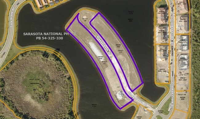
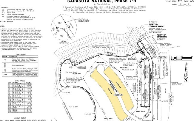
Sarasota National Phase 7-R
0463-00-3400
TRACT 317, SARASOTA NATIONAL PHASE 7-R, LESS LANDS DESC IN ORI 2021117802, 2021212371 & 2022067609
Residentialacreage
Sarasota
AE
Florida
12115C0342G
317
2024
0.11 AC
2025
Sarasota Outlying
002510
Tampa/St Petersburg
DEMOGRAPHICS near Staggerbush Dr
1 Mile
3 Mile
5 Mile
2024 Total Population
3,236
42,913
82,719
2029 Population
3,802
49,853
96,054
Pop Growth 2024-2029
+ 17.49%
+ 16.17%
+ 16.12%
Average Age
64
58
58
2024 Total Households
1,660
21,038
40,387
HH Growth 2024-2029
+ 17.59%
+ 16.23%
+ 16.14%
Median Household Inc
$85,266
$76,792
$75,664
Avg Household Size
1.90
2.00
2.00
2024 Avg HH Vehicles
2.00
2.00
2.00
Median Home Value
$348,743
$333,935
$333,180
Median Year Built
2010
1995
1995
Nearby Places
Map Layers
Map Styles
 Street
 Aerial
- Restaurants
- Banks
- Shops
- Fitness
- Groceries
PUBLIC TRANSPORTATION
AIRPORT
Punta Gorda
DRIVE
WALK
Distance
Punta Gorda
53 min
29.4 mi
Sarasota/Bradenton International
DRIVE
WALK
Distance
Sarasota/Bradenton International
53 min
36.2 mi
Freight Ports
Port Manatee
DRIVE
WALK
Distance
Port Manatee
66 min
48.7 mi
Nearby Properties
Address
Land Use
TOTAL SIZE
Lot Size
Zoning
Address
Land Use
TOTAL SIZE
Lot Size
Zoning
251,872 SF
25.01 AC
RMF2
Address
Land Use
TOTAL SIZE
Lot Size
Zoning
191,373 SF
23.12 AC
RMF2
Address
Land Use
TOTAL SIZE
Lot Size
Zoning
173,966 SF
17 AC
CG
Address
Land Use
TOTAL SIZE
Lot Size
Zoning
149,834 SF
36.95 AC
GU
Address
Land Use
TOTAL SIZE
Lot Size
Zoning
219.10 AC
V
Address
Land Use
TOTAL SIZE
Lot Size
Zoning
159,759 SF
12.60 AC
RMF3
Address
Land Use
TOTAL SIZE
Lot Size
Zoning
201,992 SF
22.45 AC
CG
Address
Land Use
TOTAL SIZE
Lot Size
Zoning
85,177 SF
68.01 AC
RE1
Address
Land Use
TOTAL SIZE
Lot Size
Zoning
146,990 SF
8.90 AC
CG
Address
Land Use
TOTAL SIZE
Lot Size
Zoning
74,937 SF
354.80 AC
RSF2
Address
Land Use
TOTAL SIZE
Lot Size
Zoning
92,802 SF
4.78 AC
CN
Address
Land Use
TOTAL SIZE
Lot Size
Zoning
101,496 SF
19.08 AC
CG
Address
Land Use
TOTAL SIZE
Lot Size
Zoning
119,222 SF
12.47 AC
CG
Address
Land Use
TOTAL SIZE
Lot Size
Zoning
94,453 SF
10.11 AC
CG
Address
Land Use
TOTAL SIZE
Lot Size
Zoning
79,048 SF
6.92 AC
CI
Address
Land Use
TOTAL SIZE
Lot Size
Zoning
74,691 SF
2.99 AC
RSF2
Address
Land Use
TOTAL SIZE
Lot Size
Zoning
11,328 SF
30 AC
V
Address
Land Use
TOTAL SIZE
Lot Size
Zoning
121,850 SF
8.98 AC
CG
Address
Land Use
TOTAL SIZE
Lot Size
Zoning
90,484 SF
4.35 AC
CG
Address
Land Use
TOTAL SIZE
Lot Size
Zoning
82,874 SF
7.08 AC
CG
Address
Land Use
TOTAL SIZE
Lot Size
Zoning
43,592 SF
173.68 AC
RE1
Address
Land Use
TOTAL SIZE
Lot Size
Zoning
77,851 SF
1.11 AC
RMF2
Address
Land Use
TOTAL SIZE
Lot Size
Zoning
24,206 SF
4.66 AC
V
Address
Land Use
TOTAL SIZE
Lot Size
Zoning
4,401 SF
19.27 AC
RMH
Address
Land Use
TOTAL SIZE
Lot Size
Zoning
34,401 SF
76.70 AC
GU
Address
Land Use
TOTAL SIZE
Lot Size
Zoning
30,476 SF
3.82 AC
CI
Address
Land Use
TOTAL SIZE
Lot Size
Zoning
77,801 SF
3.16 AC
CG
Address
Land Use
TOTAL SIZE
Lot Size
Zoning
9,519 SF
1.13 AC
RE2
Address
Land Use
TOTAL SIZE
Lot Size
Zoning
40,333 SF
10.86 AC
RSF2
Address
Land Use
TOTAL SIZE
Lot Size
Zoning
4,990 SF
11.86 AC
OUE1
The World's #1 Commercial Real Estate Marketplace
Connect with us
© 2025 CoStar Group
The information above has been obtained from sources believed reliable. While we do not doubt its accuracy we have not verified it and make no guarantee, warranty or representation about it. It is your responsibility to independently confirm its accuracy and completeness. Any projections, opinions, assumptions, or estimates used are for example only and do not represent the current or future performance of the property. The value of this transaction to you depends on tax and other factors which should be evaluated by your tax, financial, and legal advisors. You and your advisors should conduct a careful, independent investigation of the property to determine to your satisfaction the suitability of the property for your needs.