Property Record
Stampmill Dr, Wadsworth, NV 89442
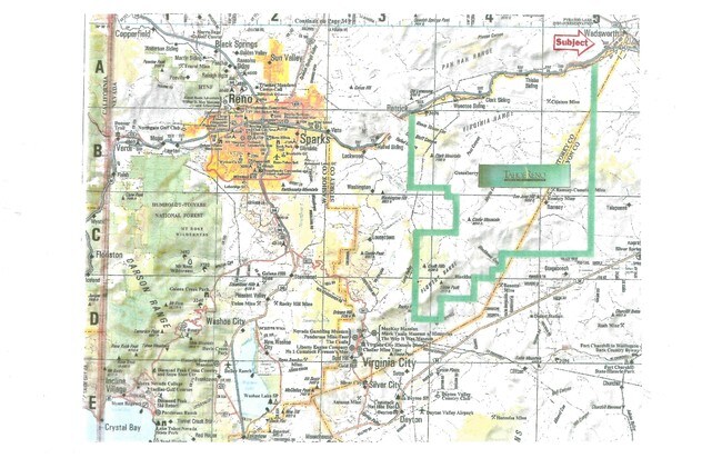

Property Detail
Stampmill Dr
084-291-38
FR SEC 7 TWP 20 RGE 24
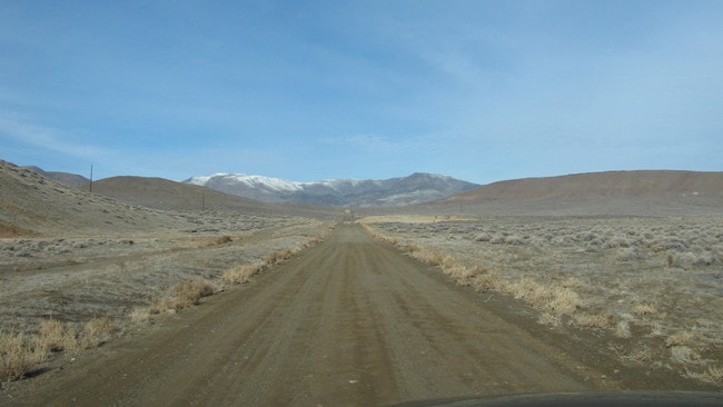
Vacantlandnec
WASHOE
MDS
Nevada
B and X Area of moderate flood hazard, usually the area between the limits of the 100-year and 500-year floods.
108.41 AC
0
N Outlying Washoe County
2026
Reno/Sparks
003501
Reno, NV
NEARBY LISTINGS FOR SALE OR LEASE
DEMOGRAPHICS near Stampmill Dr
1 mile
3 mile
5 mile
2024 Total Population
70
702
7,547
2029 Population
74
700
7,827
Pop Growth 2024-2029
+ 5.71%
(0.28%)
+ 3.71%
Average Age
45
41
39
2024 Total Households
25
252
2,819
HH Growth 2024-2029
+ 4.00%
(0.40%)
+ 3.80%
Median Household Inc
$94,999
$77,315
$81,764
Avg Household Size
2.70
2.70
2.60
2024 Avg HH Vehicles
3.00
2.00
2.00
Median Home Value
$696,428
$348,000
$332,872
Median Year Built
1999
1989
1993
Nearby Places
Map Layers
Map Styles
 Street
 Aerial
Transit
 Traffic
 Biking
Places
Listings with unknown addresses are not visible on the map
- Restaurants
- Banks
- Shops
- Fitness
- Groceries
PUBLIC TRANSPORTATION
AIRPORT
Reno/Tahoe International
Drive
Walk
Distance
Reno/Tahoe International
58 min
35.8 mi
Freight Ports
Port of Stockton
Drive
Walk
Distance
Port of Stockton
243 min
210.1 mi
SALE & LEASE HISTORY
LISTING DATE
SALE/LEASE

Sep 24, 2016
For Sale
Nearby Properties
Address
Land Use
TOTAL SIZE
Lot Size
Zoning
Address
Land Use
TOTAL SIZE
Lot Size
Zoning
267.40 AC
M1
Address
Land Use
TOTAL SIZE
Lot Size
Zoning
28.88 AC
RR1
Address
Land Use
TOTAL SIZE
Lot Size
Zoning
498.77 AC
GR
Address
Land Use
TOTAL SIZE
Lot Size
Zoning
465,120 SF
24.16 AC
I
Address
Land Use
TOTAL SIZE
Lot Size
Zoning
20,357 SF
74.69 AC
A
Address
Land Use
TOTAL SIZE
Lot Size
Zoning
44,589 SF
1.95 AC
C2
Address
Land Use
TOTAL SIZE
Lot Size
Zoning
10,645 SF
10.03 AC
C2
Address
Land Use
TOTAL SIZE
Lot Size
Zoning
10,308 SF
9.07 AC
C2
Address
Land Use
TOTAL SIZE
Lot Size
Zoning
23,439 SF
15,292.84 AC
WB 1% / TL
Address
Land Use
TOTAL SIZE
Lot Size
Zoning
30.74 AC
GR
Address
Land Use
TOTAL SIZE
Lot Size
Zoning
13,128 SF
5.05 AC
I
Address
Land Use
TOTAL SIZE
Lot Size
Zoning
16,200 SF
4.40 AC
C2
Address
Land Use
TOTAL SIZE
Lot Size
Zoning
795.84 AC
NOLU
Address
Land Use
TOTAL SIZE
Lot Size
Zoning
20,952 SF
12 AC
PSP
Address
Land Use
TOTAL SIZE
Lot Size
Zoning
3,528 SF
6.49 AC
C2
Address
Land Use
TOTAL SIZE
Lot Size
Zoning
27.83 AC
I
Address
Land Use
TOTAL SIZE
Lot Size
Zoning
1,890 SF
112.91 AC
MDS 60% /
Address
Land Use
TOTAL SIZE
Lot Size
Zoning
632.86 AC
GR
Address
Land Use
TOTAL SIZE
Lot Size
Zoning
27.90 AC
MU
Address
Land Use
TOTAL SIZE
Lot Size
Zoning
9,231 SF
5.33 AC
TC
Address
Land Use
TOTAL SIZE
Lot Size
Zoning
37.88 AC
I
Address
Land Use
TOTAL SIZE
Lot Size
Zoning
8,500 SF
1.90 AC
C2
Address
Land Use
TOTAL SIZE
Lot Size
Zoning
4.74 AC
TC
Address
Land Use
TOTAL SIZE
Lot Size
Zoning
8,800 SF
153.08 AC
GR
Address
Land Use
TOTAL SIZE
Lot Size
Zoning
46.36 AC
MDS
Address
Land Use
TOTAL SIZE
Lot Size
Zoning
40.11 AC
MDR
Address
Land Use
TOTAL SIZE
Lot Size
Zoning
6.86 AC
I
Address
Land Use
TOTAL SIZE
Lot Size
Zoning
38.24 AC
GR 89%/WB
Address
Land Use
TOTAL SIZE
Lot Size
Zoning
6.51 AC
I
The World's #1 Commercial Real Estate Marketplace
Connect with us
© 2026 CoStar Group
The information above has been obtained from sources believed reliable. While we do not doubt its accuracy we have not verified it and make no guarantee, warranty or representation about it. It is your responsibility to independently confirm its accuracy and completeness. Any projections, opinions, assumptions, or estimates used are for example only and do not represent the current or future performance of the property. The value of this transaction to you depends on tax and other factors which should be evaluated by your tax, financial, and legal advisors. You and your advisors should conduct a careful, independent investigation of the property to determine to your satisfaction the suitability of the property for your needs.