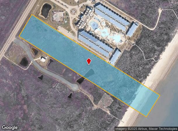
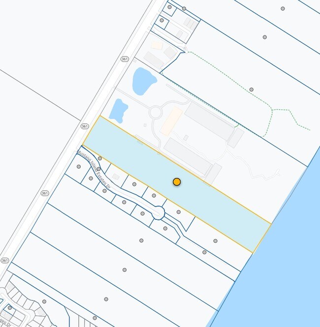
Property Record
State 361 Hwy, Port Aransas, TX 78373

NEARBY LISTINGS FOR SALE OR LEASE
Property Detail
State 361 Hwy
Corpus Christi, TX
Mustang Island Sec 2
271267
MUSTANG ISLAND SEC 2 LT 33 BLK 1 12.35 ACS
Commercialacreage
Nueces
AE
Texas
48355C0560G
33
2024
12.35 AC
2025
Mustang Is/Port Aransas
005103
Corpus Christi
DEMOGRAPHICS near State 361 Hwy
1 Mile
3 Mile
5 Mile
2024 Total Population
936
1,926
2,482
2029 Population
1,064
2,191
2,813
Pop Growth 2024-2029
+ 13.68%
+ 13.76%
+ 13.34%
Average Age
51
51
51
2024 Total Households
469
964
1,225
HH Growth 2024-2029
+ 13.65%
+ 13.80%
+ 13.31%
Median Household Inc
$75,806
$75,492
$74,999
Avg Household Size
2.00
2.00
2.00
2024 Avg HH Vehicles
2.00
2.00
2.00
Median Home Value
$663,316
$663,203
$629,184
Median Year Built
1989
1989
1990
Nearby Places
Map Layers
Map Styles
 Street
 Aerial
- Restaurants
- Banks
- Shops
- Fitness
- Groceries
PUBLIC TRANSPORTATION
AIRPORT
Corpus Christi International
DRIVE
WALK
Distance
Corpus Christi International
46 min
33.6 mi
Freight Ports
Port of Corpus Christi
DRIVE
WALK
Distance
Port of Corpus Christi
41 min
29.4 mi
Nearby Properties
Address
Land Use
TOTAL SIZE
Lot Size
Zoning
Address
Land Use
TOTAL SIZE
Lot Size
Zoning
107.64 AC
OCL
Address
Land Use
TOTAL SIZE
Lot Size
Zoning
23,663 SF
22.40 AC
OCL
Address
Land Use
TOTAL SIZE
Lot Size
Zoning
164.12 AC
OCL
Address
Land Use
TOTAL SIZE
Lot Size
Zoning
33.58 AC
OCL
Address
Land Use
TOTAL SIZE
Lot Size
Zoning
113.70 AC
OCL
Address
Land Use
TOTAL SIZE
Lot Size
Zoning
81.86 AC
OCL
Address
Land Use
TOTAL SIZE
Lot Size
Zoning
12.79 AC
OCL
Address
Land Use
TOTAL SIZE
Lot Size
Zoning
12.73 AC
OCL
Address
Land Use
TOTAL SIZE
Lot Size
Zoning
12.40 AC
OCL
Address
Land Use
TOTAL SIZE
Lot Size
Zoning
12.39 AC
OCL
Address
Land Use
TOTAL SIZE
Lot Size
Zoning
11.31 AC
OCL
Address
Land Use
TOTAL SIZE
Lot Size
Zoning
68.54 AC
OCL
Address
Land Use
TOTAL SIZE
Lot Size
Zoning
Address
Land Use
TOTAL SIZE
Lot Size
Zoning
21.12 AC
Address
Land Use
TOTAL SIZE
Lot Size
Zoning
9.36 AC
OCL
Address
Land Use
TOTAL SIZE
Lot Size
Zoning
0.19 AC
Address
Land Use
TOTAL SIZE
Lot Size
Zoning
Address
Land Use
TOTAL SIZE
Lot Size
Zoning
8.32 AC
OCL
Address
Land Use
TOTAL SIZE
Lot Size
Zoning
Address
Land Use
TOTAL SIZE
Lot Size
Zoning
7.96 AC
Address
Land Use
TOTAL SIZE
Lot Size
Zoning
Address
Land Use
TOTAL SIZE
Lot Size
Zoning
Address
Land Use
TOTAL SIZE
Lot Size
Zoning
Address
Land Use
TOTAL SIZE
Lot Size
Zoning
Address
Land Use
TOTAL SIZE
Lot Size
Zoning
Address
Land Use
TOTAL SIZE
Lot Size
Zoning
Address
Land Use
TOTAL SIZE
Lot Size
Zoning
8.58 AC
T-REC
Address
Land Use
TOTAL SIZE
Lot Size
Zoning
150.13 AC
PA
Address
Land Use
TOTAL SIZE
Lot Size
Zoning
20 AC
OCL
Address
Land Use
TOTAL SIZE
Lot Size
Zoning
144.13 AC
PA
The World's #1 Commercial Real Estate Marketplace
Connect with us
© 2026 CoStar Group
The information above has been obtained from sources believed reliable. While we do not doubt its accuracy we have not verified it and make no guarantee, warranty or representation about it. It is your responsibility to independently confirm its accuracy and completeness. Any projections, opinions, assumptions, or estimates used are for example only and do not represent the current or future performance of the property. The value of this transaction to you depends on tax and other factors which should be evaluated by your tax, financial, and legal advisors. You and your advisors should conduct a careful, independent investigation of the property to determine to your satisfaction the suitability of the property for your needs.