Property Record
State Highway 138, San Bernardino, CA 92407
NEARBY LISTINGS FOR SALE OR LEASE
-
-
View all San Bernardino listings for sale on LoopNet.com
Property Detail
State Highway 138
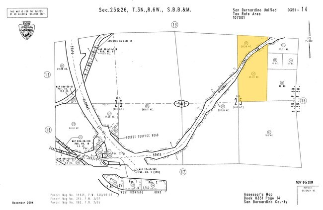
0351-141-36
W 1/2 NE 1/4 SEC 25 TP 3N R 6W LYING NLY OF STATE HGWY RECORDED BK 8236 PG 203 O R 20.28 AC M/L
Vacantlandnec
San Bernardino
D
California
06071C7180J
54.39 AC
2024
Mojave River Valley
2025
Inland Empire (California)
010805
Riverside-San Bernardino-Ontario, CA
DEMOGRAPHICS near State Highway 138
1 Mile
3 Mile
5 Mile
2024 Total Population
0
211
3,275
2029 Population
0
214
3,302
Pop Growth 2024-2029
0.00%
+ 1.42%
+ 0.82%
Average Age
0
42
41
2024 Total Households
0
68
1,079
HH Growth 2024-2029
0.00%
+ 1.47%
+ 0.65%
Median Household Inc
$0
$149,999
$79,618
Avg Household Size
.00
3.10
3.00
2024 Avg HH Vehicles
.00
4.00
3.00
Median Home Value
$0
$640,244
$653,169
Median Year Built
0
2003
2000
Nearby Places
Map Layers
Map Styles
 Street
 Aerial
- Restaurants
- Banks
- Shops
- Fitness
- Groceries
PUBLIC TRANSPORTATION
AIRPORT
Ontario International
DRIVE
WALK
Distance
Ontario International
33 min
26.9 mi
Freight Ports
Port of Long Beach
DRIVE
WALK
Distance
Port of Long Beach
94 min
79.0 mi
SALE & LEASE HISTORY
LISTING DATE
SALE/LEASE

Apr 10, 2019
For Sale
Nearby Properties
Address
Land Use
TOTAL SIZE
Lot Size
Zoning
Address
Land Use
TOTAL SIZE
Lot Size
Zoning
3,192 SF
0.93 AC
CGSCP
Address
Land Use
TOTAL SIZE
Lot Size
Zoning
4,624 SF
1.08 AC
CGSCP
Address
Land Use
TOTAL SIZE
Lot Size
Zoning
16,910 SF
1.95 AC
CG
Address
Land Use
TOTAL SIZE
Lot Size
Zoning
3,307 SF
0.88 AC
Address
Land Use
TOTAL SIZE
Lot Size
Zoning
2,244 SF
0.92 AC
CG
Address
Land Use
TOTAL SIZE
Lot Size
Zoning
1.42 AC
CGSCP
Address
Land Use
TOTAL SIZE
Lot Size
Zoning
2,059 SF
0.52 AC
CG
Address
Land Use
TOTAL SIZE
Lot Size
Zoning
Address
Land Use
TOTAL SIZE
Lot Size
Zoning
11,169 SF
28.13 AC
OHRL
Address
Land Use
TOTAL SIZE
Lot Size
Zoning
6,912 SF
4.62 AC
Address
Land Use
TOTAL SIZE
Lot Size
Zoning
20.58 AC
RS1
Address
Land Use
TOTAL SIZE
Lot Size
Zoning
3.48 AC
RC
Address
Land Use
TOTAL SIZE
Lot Size
Zoning
35 AC
RS1
Address
Land Use
TOTAL SIZE
Lot Size
Zoning
25.87 AC
RS1
Address
Land Use
TOTAL SIZE
Lot Size
Zoning
2,702 SF
1.77 AC
Address
Land Use
TOTAL SIZE
Lot Size
Zoning
0.53 AC
CG
Address
Land Use
TOTAL SIZE
Lot Size
Zoning
47.50 AC
RC
Address
Land Use
TOTAL SIZE
Lot Size
Zoning
28.25 AC
Address
Land Use
TOTAL SIZE
Lot Size
Zoning
0.64 AC
RC
Address
Land Use
TOTAL SIZE
Lot Size
Zoning
1.30 AC
Address
Land Use
TOTAL SIZE
Lot Size
Zoning
10.76 AC
Address
Land Use
TOTAL SIZE
Lot Size
Zoning
10.69 AC
Address
Land Use
TOTAL SIZE
Lot Size
Zoning
4.77 AC
OHRL
Address
Land Use
TOTAL SIZE
Lot Size
Zoning
13.35 AC
OHCG
The World's #1 Commercial Real Estate Marketplace
Connect with us
© 2025 CoStar Group
The information above has been obtained from sources believed reliable. While we do not doubt its accuracy we have not verified it and make no guarantee, warranty or representation about it. It is your responsibility to independently confirm its accuracy and completeness. Any projections, opinions, assumptions, or estimates used are for example only and do not represent the current or future performance of the property. The value of this transaction to you depends on tax and other factors which should be evaluated by your tax, financial, and legal advisors. You and your advisors should conduct a careful, independent investigation of the property to determine to your satisfaction the suitability of the property for your needs.