Property Record
State Highway 289, Sherman, TX 75092

Property Detail
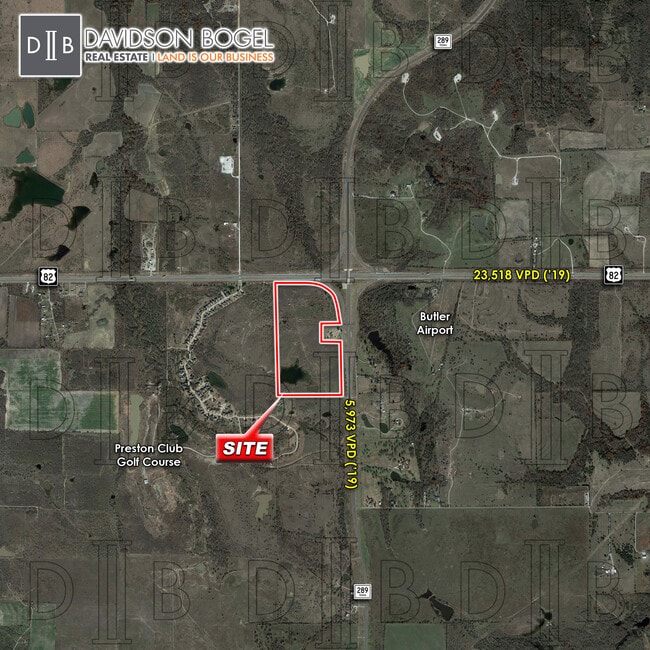
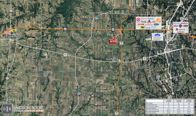
State Highway 289
119124
G-1025 RITCHEY H A-G1025, ACRES 63.244
Farms
GRAYSON
B and X Area of moderate flood hazard, usually the area between the limits of the 100-year and 500-year floods.
Texas
2024
63.24 AC
2025
Sherman
001101
Other Market Areas
936 SF
Sherman-Denison, TX
NEARBY LISTINGS FOR SALE OR LEASE
DEMOGRAPHICS near State Highway 289
1 mile
3 mile
5 mile
2025 Total Population
438
1,651
24,041
2030 Population
472
1,787
26,020
Pop Growth 2025-2030
+ 7.76%
+ 8.24%
+ 8.23%
Average Age
40
41
40
2025 Total Households
156
619
9,917
HH Growth 2025-2030
+ 7.69%
+ 8.24%
+ 8.31%
Median Household Inc
$72,499
$84,772
$59,893
Avg Household Size
2.70
2.60
2.40
2025 Avg HH Vehicles
3.00
2.00
2.00
Median Home Value
$293,749
$373,026
$323,067
Median Year Built
1994
1995
1985
Nearby Places
Map Layers
Map Styles
 Street
 Aerial
Transit
 Traffic
 Biking
Places
Listings with unknown addresses are not visible on the map
- Restaurants
- Banks
- Shops
- Fitness
- Groceries
SALE & LEASE HISTORY
LISTING DATE
SALE/LEASE

Feb 05, 2019
For Sale
Aug 21, 2020
For Sale
Apr 11, 2018
For Sale
Nearby Properties
Address
Land Use
TOTAL SIZE
Lot Size
Zoning
Address
Land Use
TOTAL SIZE
Lot Size
Zoning
315,715 SF
24.68 AC
Address
Land Use
TOTAL SIZE
Lot Size
Zoning
32,456 SF
6.71 AC
Address
Land Use
TOTAL SIZE
Lot Size
Zoning
127,360 SF
19.18 AC
Address
Land Use
TOTAL SIZE
Lot Size
Zoning
60,160 SF
30.34 AC
Address
Land Use
TOTAL SIZE
Lot Size
Zoning
Address
Land Use
TOTAL SIZE
Lot Size
Zoning
2,400 SF
26.33 AC
Address
Land Use
TOTAL SIZE
Lot Size
Zoning
28,560 SF
10 AC
Address
Land Use
TOTAL SIZE
Lot Size
Zoning
13,200 SF
9.42 AC
Address
Land Use
TOTAL SIZE
Lot Size
Zoning
15,898 SF
40.44 AC
Address
Land Use
TOTAL SIZE
Lot Size
Zoning
29,260 SF
10 AC
Address
Land Use
TOTAL SIZE
Lot Size
Zoning
14,360 SF
2.39 AC
Address
Land Use
TOTAL SIZE
Lot Size
Zoning
45,560 SF
6.38 AC
Address
Land Use
TOTAL SIZE
Lot Size
Zoning
6,220 SF
241.44 AC
Address
Land Use
TOTAL SIZE
Lot Size
Zoning
5,000 SF
3 AC
Address
Land Use
TOTAL SIZE
Lot Size
Zoning
19.51 AC
Address
Land Use
TOTAL SIZE
Lot Size
Zoning
49,494 SF
40.97 AC
Address
Land Use
TOTAL SIZE
Lot Size
Zoning
5,973 SF
9.65 AC
Address
Land Use
TOTAL SIZE
Lot Size
Zoning
12,712 SF
36.63 AC
Address
Land Use
TOTAL SIZE
Lot Size
Zoning
8,752 SF
9.47 AC
Address
Land Use
TOTAL SIZE
Lot Size
Zoning
3,760 SF
19.52 AC
Address
Land Use
TOTAL SIZE
Lot Size
Zoning
9,400 SF
0.98 AC
Address
Land Use
TOTAL SIZE
Lot Size
Zoning
3,435 SF
18.33 AC
Address
Land Use
TOTAL SIZE
Lot Size
Zoning
7.43 AC
Address
Land Use
TOTAL SIZE
Lot Size
Zoning
750 SF
9 AC
Address
Land Use
TOTAL SIZE
Lot Size
Zoning
3,423 SF
10 AC
Address
Land Use
TOTAL SIZE
Lot Size
Zoning
3,347 SF
15 AC
Address
Land Use
TOTAL SIZE
Lot Size
Zoning
7.40 AC
Address
Land Use
TOTAL SIZE
Lot Size
Zoning
3,488 SF
14.84 AC
Address
Land Use
TOTAL SIZE
Lot Size
Zoning
2,931 SF
29.24 AC
Address
Land Use
TOTAL SIZE
Lot Size
Zoning
4,007 SF
259.69 AC
The World's #1 Commercial Real Estate Marketplace
Connect with us
© 2026 CoStar Group
The information above has been obtained from sources believed reliable. While we do not doubt its accuracy we have not verified it and make no guarantee, warranty or representation about it. It is your responsibility to independently confirm its accuracy and completeness. Any projections, opinions, assumptions, or estimates used are for example only and do not represent the current or future performance of the property. The value of this transaction to you depends on tax and other factors which should be evaluated by your tax, financial, and legal advisors. You and your advisors should conduct a careful, independent investigation of the property to determine to your satisfaction the suitability of the property for your needs.