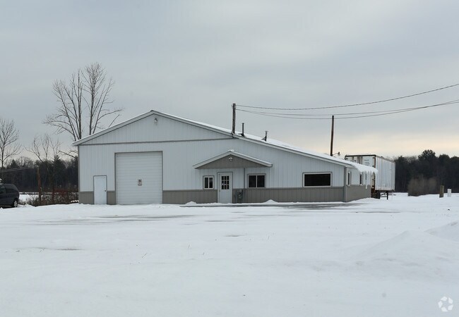
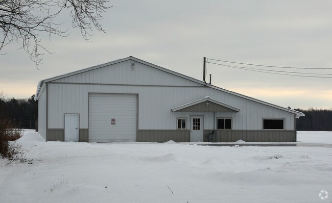
Property Record
State Highway 30, Amsterdam, NY 12010

NEARBY LISTINGS FOR SALE OR LEASE
-
-
View all Amsterdam listings for sale on LoopNet.com
Property Detail
State Highway 30
Gloversville, NY
Fulton
173600-178-000-0002-022-000-0000
New York
Warehouse
22.000
2025
76.10 AC
2024
Fulton County
070600
Albany/Schenectady/Troy
4,800 SF
DEMOGRAPHICS near State Highway 30
1 Mile
3 Mile
5 Mile
2024 Total Population
672
5,701
26,920
2029 Population
658
5,660
26,786
Pop Growth 2024-2029
(2.08%)
(0.72%)
(0.50%)
Average Age
42
45
42
2024 Total Households
277
2,337
11,267
HH Growth 2024-2029
(2.17%)
(0.68%)
(0.47%)
Median Household Inc
$75,798
$60,806
$51,641
Avg Household Size
2.40
2.40
2.30
2024 Avg HH Vehicles
2.00
2.00
2.00
Median Home Value
$215,278
$201,899
$152,970
Median Year Built
1992
1982
1951
Nearby Places
Map Layers
Map Styles
 Street
 Aerial
- Restaurants
- Banks
- Shops
- Fitness
- Groceries
PUBLIC TRANSPORTATION
COMMUTER RAIL
Amsterdam (Toronto - New York - VIA Rail)
DRIVE
WALK
Distance
Amsterdam (Toronto - New York - VIA Rail)
11 min
5.4 mi
Amsterdam Amtrak Station (Empire Service - Amtrak, Maple Leaf - Amtrak)
DRIVE
WALK
Distance
Amsterdam Amtrak Station (Empire Service - Amtrak, Maple Leaf - Amtrak)
11 min
5.4 mi
AIRPORT
Albany International
DRIVE
WALK
Distance
Albany International
55 min
34.2 mi
Freight Ports
Albany, NY Port
DRIVE
WALK
Distance
Albany, NY Port
56 min
40.8 mi
Nearby Properties
Address
Land Use
TOTAL SIZE
Lot Size
Zoning
Address
Land Use
TOTAL SIZE
Lot Size
Zoning
113,040 SF
5.70 AC
01 - NOT Z
Address
Land Use
TOTAL SIZE
Lot Size
Zoning
2,688 SF
49.10 AC
05 - COMME
Address
Land Use
TOTAL SIZE
Lot Size
Zoning
21,485 SF
64.22 AC
05 - COMME
Address
Land Use
TOTAL SIZE
Lot Size
Zoning
9,390 SF
21.89 AC
08 - GOVER
Address
Land Use
TOTAL SIZE
Lot Size
Zoning
9.30 AC
RH
Address
Land Use
TOTAL SIZE
Lot Size
Zoning
Address
Land Use
TOTAL SIZE
Lot Size
Zoning
134,563 SF
12.90 AC
Address
Land Use
TOTAL SIZE
Lot Size
Zoning
8,056 SF
25.50 AC
C1
Address
Land Use
TOTAL SIZE
Lot Size
Zoning
126,842 SF
11.50 AC
B1
Address
Land Use
TOTAL SIZE
Lot Size
Zoning
16.50 AC
Address
Land Use
TOTAL SIZE
Lot Size
Zoning
7,472 SF
4 AC
01 - NOT Z
Address
Land Use
TOTAL SIZE
Lot Size
Zoning
Address
Land Use
TOTAL SIZE
Lot Size
Zoning
14,068 SF
8.10 AC
RH
Address
Land Use
TOTAL SIZE
Lot Size
Zoning
9 AC
01 - NOT Z
Address
Land Use
TOTAL SIZE
Lot Size
Zoning
980 SF
18.10 AC
05 - COMME
Address
Land Use
TOTAL SIZE
Lot Size
Zoning
13,449 SF
4.60 AC
05 - COMME
Address
Land Use
TOTAL SIZE
Lot Size
Zoning
720 SF
19.80 AC
05 - COMME
Address
Land Use
TOTAL SIZE
Lot Size
Zoning
7,881 SF
3.80 AC
C1
Address
Land Use
TOTAL SIZE
Lot Size
Zoning
18,158 SF
7.60 AC
05 - COMME
Address
Land Use
TOTAL SIZE
Lot Size
Zoning
11.60 AC
Address
Land Use
TOTAL SIZE
Lot Size
Zoning
2,250 SF
39.50 AC
01 - NOT Z
Address
Land Use
TOTAL SIZE
Lot Size
Zoning
4,000 SF
1.30 AC
C1
Address
Land Use
TOTAL SIZE
Lot Size
Zoning
9.50 AC
R2
Address
Land Use
TOTAL SIZE
Lot Size
Zoning
1,200 SF
3.25 AC
RH
Address
Land Use
TOTAL SIZE
Lot Size
Zoning
15.40 AC
B1
Address
Land Use
TOTAL SIZE
Lot Size
Zoning
18,000 SF
3.65 AC
05 - COMME
Address
Land Use
TOTAL SIZE
Lot Size
Zoning
13,540 SF
2.80 AC
C1
Address
Land Use
TOTAL SIZE
Lot Size
Zoning
1.50 AC
R1
Address
Land Use
TOTAL SIZE
Lot Size
Zoning
2,088 SF
36 AC
01 - NOT Z
Address
Land Use
TOTAL SIZE
Lot Size
Zoning
868 SF
6.40 AC
R1
The World's #1 Commercial Real Estate Marketplace
Connect with us
© 2026 CoStar Group
The information above has been obtained from sources believed reliable. While we do not doubt its accuracy we have not verified it and make no guarantee, warranty or representation about it. It is your responsibility to independently confirm its accuracy and completeness. Any projections, opinions, assumptions, or estimates used are for example only and do not represent the current or future performance of the property. The value of this transaction to you depends on tax and other factors which should be evaluated by your tax, financial, and legal advisors. You and your advisors should conduct a careful, independent investigation of the property to determine to your satisfaction the suitability of the property for your needs.