Property Record
14801 Highway 361, Corpus Christi, TX 78418
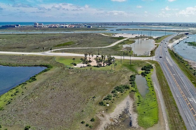

Property Detail
14801 Highway 361
202789
BRYAN WM SUR 606 LS 64, 32.5734 ACS ICL
Commercialacreage
NUECES
ICL
Texas
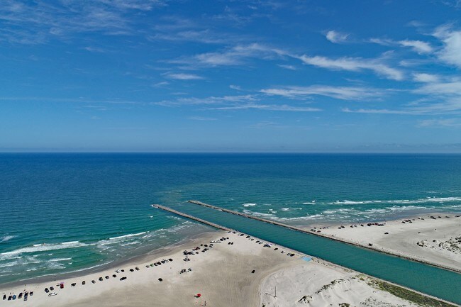
AE The base floodplain where base flood elevations are provided. AE Zones are now used on new format FIRMs instead of A1-A30 Zones.
32.57 AC
2024
Flour Bluff/Padre Island
2025
Corpus Christi
006205
Corpus Christi, TX
1,152 SF
NEARBY LISTINGS FOR SALE OR LEASE
DEMOGRAPHICS near 14801 Highway 361
1 mile
3 mile
5 mile
2025 Total Population
1
6,924
13,092
2030 Population
1
7,371
13,750
Pop Growth 2025-2030
0.00%
+ 6.46%
+ 5.03%
Average Age
0
46
45
2025 Total Households
1
3,117
5,643
HH Growth 2025-2030
0.00%
+ 6.71%
+ 5.23%
Median Household Inc
$0
$122,451
$129,569
Avg Household Size
.00
2.20
2.30
2025 Avg HH Vehicles
.00
2.00
2.00
Median Home Value
$0
$425,477
$442,754
Median Year Built
0
1996
1999
Nearby Places
Map Layers
Map Styles
 Street
 Aerial
Transit
 Traffic
 Biking
Places
Listings with unknown addresses are not visible on the map
- Restaurants
- Banks
- Shops
- Fitness
- Groceries
PUBLIC TRANSPORTATION
AIRPORT
Corpus Christi International
Drive
Walk
Distance
Corpus Christi International
33 min
23.9 mi
Freight Ports
Port of Corpus Christi
Drive
Walk
Distance
Port of Corpus Christi
27 min
19.8 mi
SALE & LEASE HISTORY
LISTING DATE
SALE/LEASE

Nov 23, 2018
For Sale
Nearby Properties
Address
Land Use
TOTAL SIZE
Lot Size
Zoning
Address
Land Use
TOTAL SIZE
Lot Size
Zoning
Address
Land Use
TOTAL SIZE
Lot Size
Zoning
138.88 AC
ATIO
Address
Land Use
TOTAL SIZE
Lot Size
Zoning
210 AC
F-R&AT
Address
Land Use
TOTAL SIZE
Lot Size
Zoning
176.01 AC
Address
Land Use
TOTAL SIZE
Lot Size
Zoning
480.05 AC
R1B
Address
Land Use
TOTAL SIZE
Lot Size
Zoning
80,205 SF
2.90 AC
B2IO
Address
Land Use
TOTAL SIZE
Lot Size
Zoning
19.57 AC
B2
Address
Land Use
TOTAL SIZE
Lot Size
Zoning
9,941 SF
195.92 AC
FRIO
Address
Land Use
TOTAL SIZE
Lot Size
Zoning
39.82 AC
ATIO
Address
Land Use
TOTAL SIZE
Lot Size
Zoning
51,256 SF
1.43 AC
AT
Address
Land Use
TOTAL SIZE
Lot Size
Zoning
11,170 SF
16.14 AC
R1B
Address
Land Use
TOTAL SIZE
Lot Size
Zoning
30,068 SF
3.10 AC
B2A
Address
Land Use
TOTAL SIZE
Lot Size
Zoning
289.11 AC
R1B
Address
Land Use
TOTAL SIZE
Lot Size
Zoning
Address
Land Use
TOTAL SIZE
Lot Size
Zoning
14,896 SF
1.93 AC
Address
Land Use
TOTAL SIZE
Lot Size
Zoning
35,914 SF
4.91 AC
B2A
Address
Land Use
TOTAL SIZE
Lot Size
Zoning
125,343 SF
28.63 AC
Address
Land Use
TOTAL SIZE
Lot Size
Zoning
5,520 SF
20 AC
FR
Address
Land Use
TOTAL SIZE
Lot Size
Zoning
26.84 AC
R1BIO
Address
Land Use
TOTAL SIZE
Lot Size
Zoning
24,790 SF
2.75 AC
B-2A
Address
Land Use
TOTAL SIZE
Lot Size
Zoning
18,500 SF
2 AC
B2AIO
Address
Land Use
TOTAL SIZE
Lot Size
Zoning
27,381 SF
3.20 AC
R2
Address
Land Use
TOTAL SIZE
Lot Size
Zoning
24,215 SF
2.15 AC
B-2A
Address
Land Use
TOTAL SIZE
Lot Size
Zoning
6.44 AC
B-2
Address
Land Use
TOTAL SIZE
Lot Size
Zoning
14,874 SF
0.36 AC
ATPUD2
Address
Land Use
TOTAL SIZE
Lot Size
Zoning
6.39 AC
B2IO
Address
Land Use
TOTAL SIZE
Lot Size
Zoning
14,874 SF
0.36 AC
ATPUD2
Address
Land Use
TOTAL SIZE
Lot Size
Zoning
6.63 AC
B2
Address
Land Use
TOTAL SIZE
Lot Size
Zoning
17,221 SF
1.88 AC
B2AIO
Address
Land Use
TOTAL SIZE
Lot Size
Zoning
69.11 AC
OCL
The World's #1 Commercial Real Estate Marketplace
Connect with us
© 2026 CoStar Group
The information above has been obtained from sources believed reliable. While we do not doubt its accuracy we have not verified it and make no guarantee, warranty or representation about it. It is your responsibility to independently confirm its accuracy and completeness. Any projections, opinions, assumptions, or estimates used are for example only and do not represent the current or future performance of the property. The value of this transaction to you depends on tax and other factors which should be evaluated by your tax, financial, and legal advisors. You and your advisors should conduct a careful, independent investigation of the property to determine to your satisfaction the suitability of the property for your needs.