Property Record
State Rd, Hebron, IN 46341
NEARBY LISTINGS FOR SALE OR LEASE
-
-
View all Hebron listings for sale on LoopNet.com
Property Detail
State Rd
Chicago-Naperville-Elgin, IL-IN
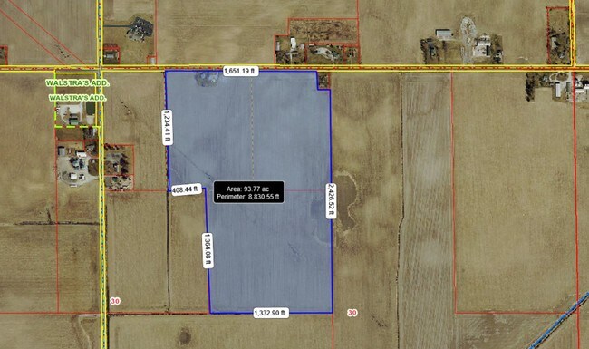
E.13.75 AC OF NW1/4 NW1/4 & W.15 AC OF NE1/4 NW1/4 S.30 T.33 R.7 EX 172.03X155.5 FT PARCEL 28.136 AC
45-21-30-100-004.000-012
Lake
Agriculturalland
Indiana
X
1
18089C0375E
24.41 AC
2024
Indiana
2025
Chicago
043404
DEMOGRAPHICS near State Rd
1 Mile
3 Mile
5 Mile
2024 Total Population
33
1,154
6,813
2029 Population
32
1,133
6,811
Pop Growth 2024-2029
(3.03%)
(1.82%)
(0.03%)
Average Age
44
44
41
2024 Total Households
13
471
2,655
HH Growth 2024-2029
0.00%
(1.91%)
(0.08%)
Median Household Inc
$87,500
$88,051
$83,474
Avg Household Size
2.40
2.50
2.60
2024 Avg HH Vehicles
2.00
2.00
2.00
Median Home Value
$287,499
$281,292
$216,010
Median Year Built
1981
1979
1977
Nearby Places
Map Layers
Map Styles
 Street
 Aerial
- Restaurants
- Banks
- Shops
- Fitness
- Groceries
SALE & LEASE HISTORY
LISTING DATE
SALE/LEASE

Jan 23, 2019
For Sale
Jan 18, 2019
For Sale
Nearby Properties
Address
Land Use
TOTAL SIZE
Lot Size
Zoning
Address
Land Use
TOTAL SIZE
Lot Size
Zoning
256,143 SF
57.32 AC
Address
Land Use
TOTAL SIZE
Lot Size
Zoning
40,031 SF
19.45 AC
Address
Land Use
TOTAL SIZE
Lot Size
Zoning
20,889 SF
25.59 AC
R33
Address
Land Use
TOTAL SIZE
Lot Size
Zoning
976 SF
387.49 AC
Address
Land Use
TOTAL SIZE
Lot Size
Zoning
10,755 SF
19.07 AC
Address
Land Use
TOTAL SIZE
Lot Size
Zoning
42,336 SF
3.46 AC
Address
Land Use
TOTAL SIZE
Lot Size
Zoning
4,272 SF
49.49 AC
Address
Land Use
TOTAL SIZE
Lot Size
Zoning
10,982 SF
10.65 AC
R33
Address
Land Use
TOTAL SIZE
Lot Size
Zoning
4,193 SF
1.17 AC
Address
Land Use
TOTAL SIZE
Lot Size
Zoning
32,812 SF
8.32 AC
R33
Address
Land Use
TOTAL SIZE
Lot Size
Zoning
8,190 SF
121.45 AC
Address
Land Use
TOTAL SIZE
Lot Size
Zoning
3,480 SF
1.52 AC
R33
Address
Land Use
TOTAL SIZE
Lot Size
Zoning
7,094 SF
44.44 AC
Address
Land Use
TOTAL SIZE
Lot Size
Zoning
3,330 SF
461.19 AC
Address
Land Use
TOTAL SIZE
Lot Size
Zoning
25,000 SF
2.21 AC
R33
Address
Land Use
TOTAL SIZE
Lot Size
Zoning
7,137 SF
27.12 AC
Address
Land Use
TOTAL SIZE
Lot Size
Zoning
6,398 SF
87 SF
Address
Land Use
TOTAL SIZE
Lot Size
Zoning
8,109 SF
3.41 AC
Address
Land Use
TOTAL SIZE
Lot Size
Zoning
9,783 SF
9.89 AC
Address
Land Use
TOTAL SIZE
Lot Size
Zoning
15,664 SF
1.79 AC
Address
Land Use
TOTAL SIZE
Lot Size
Zoning
343.56 AC
Address
Land Use
TOTAL SIZE
Lot Size
Zoning
4,496 SF
20 AC
Address
Land Use
TOTAL SIZE
Lot Size
Zoning
1,872 SF
314.82 AC
Address
Land Use
TOTAL SIZE
Lot Size
Zoning
300 AC
Address
Land Use
TOTAL SIZE
Lot Size
Zoning
960 SF
3.98 AC
Address
Land Use
TOTAL SIZE
Lot Size
Zoning
5,412 SF
9.84 AC
Address
Land Use
TOTAL SIZE
Lot Size
Zoning
5,133 SF
134 AC
Address
Land Use
TOTAL SIZE
Lot Size
Zoning
9,400 SF
10 AC
Address
Land Use
TOTAL SIZE
Lot Size
Zoning
2,523 SF
275.88 AC
Address
Land Use
TOTAL SIZE
Lot Size
Zoning
304.79 AC
The World's #1 Commercial Real Estate Marketplace
Connect with us
© 2026 CoStar Group
The information above has been obtained from sources believed reliable. While we do not doubt its accuracy we have not verified it and make no guarantee, warranty or representation about it. It is your responsibility to independently confirm its accuracy and completeness. Any projections, opinions, assumptions, or estimates used are for example only and do not represent the current or future performance of the property. The value of this transaction to you depends on tax and other factors which should be evaluated by your tax, financial, and legal advisors. You and your advisors should conduct a careful, independent investigation of the property to determine to your satisfaction the suitability of the property for your needs.