Property Record
State Road 19, Tavares, FL 32778
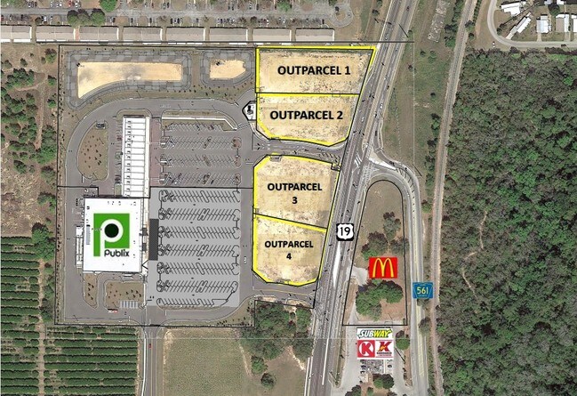
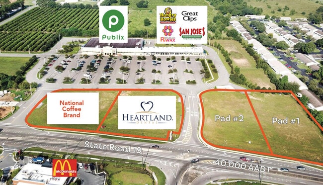
Current Lease Availabilities
NEARBY LISTINGS FOR SALE OR LEASE
Property Detail
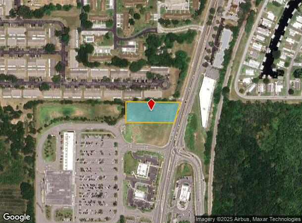
State Road 19
Orlando-Kissimmee-Sanford, FL
Tavares Cross
06-20-26-1000-000-00300
TAVARES CROSSROADS PB 68 PG 65-67 LOT 3 ORB 5866 PG 2337
Commercialacreage
Lake
X
Florida
12069C0361E
3
2024
1.18 AC
2026
Lake County
030803
Orlando
DEMOGRAPHICS near State Road 19
1 Mile
3 Mile
5 Mile
2024 Total Population
4,690
20,377
49,746
2029 Population
5,553
24,056
58,410
Pop Growth 2024-2029
+ 18.40%
+ 18.05%
+ 17.42%
Average Age
43
48
47
2024 Total Households
1,910
8,961
21,875
HH Growth 2024-2029
+ 18.38%
+ 18.12%
+ 17.31%
Median Household Inc
$50,521
$53,902
$52,071
Avg Household Size
2.30
2.10
2.20
2024 Avg HH Vehicles
1.00
2.00
2.00
Median Home Value
$139,027
$205,753
$213,654
Median Year Built
1990
1990
1988
Nearby Places
Map Layers
Map Styles
 Street
 Aerial
- Restaurants
- Banks
- Shops
- Fitness
- Groceries
Nearby Properties
Address
Land Use
TOTAL SIZE
Lot Size
Zoning
Address
Land Use
TOTAL SIZE
Lot Size
Zoning
15,600 SF
9.32 AC
PFD
Address
Land Use
TOTAL SIZE
Lot Size
Zoning
481,096 SF
2.17 AC
PFD
Address
Land Use
TOTAL SIZE
Lot Size
Zoning
138,613 SF
24.59 AC
PFD
Address
Land Use
TOTAL SIZE
Lot Size
Zoning
97,053 SF
1.50 AC
PFD
Address
Land Use
TOTAL SIZE
Lot Size
Zoning
145,614 SF
11.27 AC
PD
Address
Land Use
TOTAL SIZE
Lot Size
Zoning
29,066 SF
0.76 AC
Address
Land Use
TOTAL SIZE
Lot Size
Zoning
149,998 SF
8.73 AC
I
Address
Land Use
TOTAL SIZE
Lot Size
Zoning
2,000 SF
3.04 AC
PFD
Address
Land Use
TOTAL SIZE
Lot Size
Zoning
45,310 SF
2.93 AC
PFD
Address
Land Use
TOTAL SIZE
Lot Size
Zoning
Address
Land Use
TOTAL SIZE
Lot Size
Zoning
36,629 SF
282.12 AC
CFD
Address
Land Use
TOTAL SIZE
Lot Size
Zoning
87,462 SF
4.94 AC
RMF3
Address
Land Use
TOTAL SIZE
Lot Size
Zoning
121,815 SF
33.48 AC
PD
Address
Land Use
TOTAL SIZE
Lot Size
Zoning
2,000 SF
19.74 AC
PFD
Address
Land Use
TOTAL SIZE
Lot Size
Zoning
2,000 SF
2.14 AC
PFD
Address
Land Use
TOTAL SIZE
Lot Size
Zoning
63,600 SF
1.24 AC
PD
Address
Land Use
TOTAL SIZE
Lot Size
Zoning
40,776 SF
2.28 AC
C1
Address
Land Use
TOTAL SIZE
Lot Size
Zoning
27,512 SF
3.64 AC
PD
Address
Land Use
TOTAL SIZE
Lot Size
Zoning
46,524 SF
6.87 AC
Address
Land Use
TOTAL SIZE
Lot Size
Zoning
109,792 SF
11.83 AC
RMRP
Address
Land Use
TOTAL SIZE
Lot Size
Zoning
68,015 SF
8.53 AC
C1
Address
Land Use
TOTAL SIZE
Lot Size
Zoning
86.22 AC
PD
Address
Land Use
TOTAL SIZE
Lot Size
Zoning
42,515 SF
9.41 AC
HM
Address
Land Use
TOTAL SIZE
Lot Size
Zoning
2,000 SF
17.92 AC
PFD
Address
Land Use
TOTAL SIZE
Lot Size
Zoning
44,225 SF
15.63 AC
A
Address
Land Use
TOTAL SIZE
Lot Size
Zoning
47,748 SF
5.81 AC
PD
Address
Land Use
TOTAL SIZE
Lot Size
Zoning
17,069 SF
7.26 AC
Address
Land Use
TOTAL SIZE
Lot Size
Zoning
20,099 SF
1.80 AC
PD
Address
Land Use
TOTAL SIZE
Lot Size
Zoning
87,660 SF
6.78 AC
HM
Address
Land Use
TOTAL SIZE
Lot Size
Zoning
42,529 SF
6.43 AC
PD
The World's #1 Commercial Real Estate Marketplace
Connect with us
© 2025 CoStar Group
The information above has been obtained from sources believed reliable. While we do not doubt its accuracy we have not verified it and make no guarantee, warranty or representation about it. It is your responsibility to independently confirm its accuracy and completeness. Any projections, opinions, assumptions, or estimates used are for example only and do not represent the current or future performance of the property. The value of this transaction to you depends on tax and other factors which should be evaluated by your tax, financial, and legal advisors. You and your advisors should conduct a careful, independent investigation of the property to determine to your satisfaction the suitability of the property for your needs.