Property Record
State Road 19, Howey In The Hills, FL 34737
NEARBY LISTINGS FOR SALE OR LEASE
Property Detail
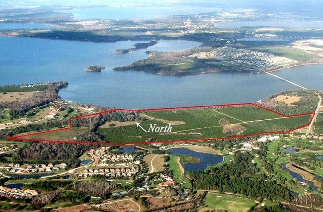
State Road 19
Orlando-Kissimmee-Sanford, FL
Acreage & Unrec
23-20-25-0004-000-01000
GOV LOTS 2 4 5 GOV LOTS 6 7 N OF HWY 48 GOV LOT 8 N OF HWY 48 & WLY OF HWY 19 GOV LOT 9 WLY OF HWY 19 IN SECTION 23 TOWNSHIP 20 SOUTH RANGE 25 EAST--LESS BEG AT SE COR OF NW 1/4 OF SE 1/4 RUN N 00DEG 04MIN 21SEC E 1314.20 FT TO SLY WATERS EDGE OF LAK
Commercialacreage
Lake
AE
Florida
12069C0485E
2
0
35.46 AC
2026
Lake County
031103
Orlando
DEMOGRAPHICS near State Road 19
1 Mile
3 Mile
5 Mile
2024 Total Population
1,225
7,241
19,720
2029 Population
1,451
8,543
23,287
Pop Growth 2024-2029
+ 18.45%
+ 17.98%
+ 18.09%
Average Age
50
51
50
2024 Total Households
533
3,162
8,534
HH Growth 2024-2029
+ 18.20%
+ 17.74%
+ 17.88%
Median Household Inc
$92,395
$77,386
$69,113
Avg Household Size
2.30
2.30
2.30
2024 Avg HH Vehicles
2.00
2.00
2.00
Median Home Value
$425,490
$288,080
$257,066
Median Year Built
1993
1999
1998
Nearby Places
Map Layers
Map Styles
 Street
 Aerial
- Restaurants
- Banks
- Shops
- Fitness
- Groceries
Nearby Properties
Address
Land Use
TOTAL SIZE
Lot Size
Zoning
Address
Land Use
TOTAL SIZE
Lot Size
Zoning
144,891 SF
288.42 AC
Address
Land Use
TOTAL SIZE
Lot Size
Zoning
510,201 SF
36.54 AC
HM
Address
Land Use
TOTAL SIZE
Lot Size
Zoning
137.28 AC
A
Address
Land Use
TOTAL SIZE
Lot Size
Zoning
Address
Land Use
TOTAL SIZE
Lot Size
Zoning
54,327 SF
168.71 AC
A
Address
Land Use
TOTAL SIZE
Lot Size
Zoning
166,821 SF
4.75 AC
IND
Address
Land Use
TOTAL SIZE
Lot Size
Zoning
120.75 AC
Address
Land Use
TOTAL SIZE
Lot Size
Zoning
116,340 SF
34.02 AC
INS
Address
Land Use
TOTAL SIZE
Lot Size
Zoning
5,788 SF
50.33 AC
R1
Address
Land Use
TOTAL SIZE
Lot Size
Zoning
6,868 SF
35.34 AC
C1
Address
Land Use
TOTAL SIZE
Lot Size
Zoning
19,591 SF
67.41 AC
CFD
Address
Land Use
TOTAL SIZE
Lot Size
Zoning
113,800 SF
17.54 AC
Address
Land Use
TOTAL SIZE
Lot Size
Zoning
67.11 AC
A
Address
Land Use
TOTAL SIZE
Lot Size
Zoning
81.15 AC
A
Address
Land Use
TOTAL SIZE
Lot Size
Zoning
20,620 SF
13.24 AC
CFD
Address
Land Use
TOTAL SIZE
Lot Size
Zoning
21,280 SF
0.53 AC
R1B
Address
Land Use
TOTAL SIZE
Lot Size
Zoning
81.03 AC
A
Address
Land Use
TOTAL SIZE
Lot Size
Zoning
19,264 SF
117.75 AC
PUD
Address
Land Use
TOTAL SIZE
Lot Size
Zoning
Address
Land Use
TOTAL SIZE
Lot Size
Zoning
10,887 SF
2.86 AC
CG
Address
Land Use
TOTAL SIZE
Lot Size
Zoning
66.29 AC
A
Address
Land Use
TOTAL SIZE
Lot Size
Zoning
10,721 SF
3.52 AC
SF4
Address
Land Use
TOTAL SIZE
Lot Size
Zoning
2,000 SF
111.35 AC
CFD
Address
Land Use
TOTAL SIZE
Lot Size
Zoning
13.72 AC
Address
Land Use
TOTAL SIZE
Lot Size
Zoning
16,626 SF
0.70 AC
IND
Address
Land Use
TOTAL SIZE
Lot Size
Zoning
35,828 SF
4.36 AC
IND
Address
Land Use
TOTAL SIZE
Lot Size
Zoning
5,238 SF
16.08 AC
A
Address
Land Use
TOTAL SIZE
Lot Size
Zoning
32,244 SF
3.39 AC
RMRP
Address
Land Use
TOTAL SIZE
Lot Size
Zoning
6,102 SF
9.72 AC
The World's #1 Commercial Real Estate Marketplace
Connect with us
© 2025 CoStar Group
The information above has been obtained from sources believed reliable. While we do not doubt its accuracy we have not verified it and make no guarantee, warranty or representation about it. It is your responsibility to independently confirm its accuracy and completeness. Any projections, opinions, assumptions, or estimates used are for example only and do not represent the current or future performance of the property. The value of this transaction to you depends on tax and other factors which should be evaluated by your tax, financial, and legal advisors. You and your advisors should conduct a careful, independent investigation of the property to determine to your satisfaction the suitability of the property for your needs.