Property Record
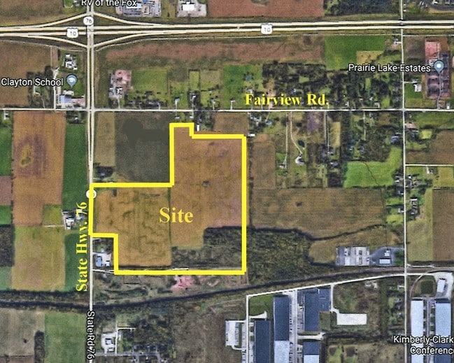
State Road 76, Neenah, WI 54956
Property Detail
State Road 76
006-0352
NE NW EXC N 473.48 FT OF E 920 FT & EXC CSM-2942 CSM- 3081 27.69 A.
Agriculturalland
WINNEBAGO
A2
Wisconsin
B and X Area of moderate flood hazard, usually the area between the limits of the 100-year and 500-year floods.
27.69 AC
2024
Appleton/Oshkosh
2024
Other Market Areas
003400
Oshkosh-Neenah, WI
NEARBY LISTINGS FOR SALE OR LEASE
DEMOGRAPHICS near State Road 76
1 mile
3 mile
5 mile
2025 Total Population
858
12,049
53,339
2030 Population
885
12,223
54,086
Pop Growth 2025-2030
+ 3.15%
+ 1.44%
+ 1.40%
Average Age
41
40
41
2025 Total Households
328
4,845
22,532
HH Growth 2025-2030
+ 3.05%
+ 1.32%
+ 1.34%
Median Household Inc
$122,499
$97,007
$74,520
Avg Household Size
2.60
2.50
2.30
2025 Avg HH Vehicles
2.00
2.00
2.00
Median Home Value
$349,315
$316,572
$238,652
Median Year Built
2003
1991
1975
Nearby Places
Map Layers
Map Styles
 Street
 Aerial
Layers
 Traffic
 Biking
Places
Listings with unknown addresses are not visible on the map
- Restaurants
- Banks
- Shops
- Fitness
- Groceries
PUBLIC TRANSPORTATION
AIRPORT
Appleton International
Drive
Walk
Distance
Appleton International
9 min
4.2 mi
Green Bay/Austin Straubel International
Drive
Walk
Distance
Green Bay/Austin Straubel International
47 min
36.8 mi
Freight Ports
Port Milwaukee
Drive
Walk
Distance
Port Milwaukee
125 min
102.1 mi
Nearby Properties
Address
Land Use
TOTAL SIZE
Lot Size
Zoning
Address
Land Use
TOTAL SIZE
Lot Size
Zoning
68.77 AC
Address
Land Use
TOTAL SIZE
Lot Size
Zoning
156.36 AC
M1
Address
Land Use
TOTAL SIZE
Lot Size
Zoning
11.99 AC
Address
Land Use
TOTAL SIZE
Lot Size
Zoning
120.73 AC
M2
Address
Land Use
TOTAL SIZE
Lot Size
Zoning
11.22 AC
Address
Land Use
TOTAL SIZE
Lot Size
Zoning
9.40 AC
Address
Land Use
TOTAL SIZE
Lot Size
Zoning
6.75 AC
M1
Address
Land Use
TOTAL SIZE
Lot Size
Zoning
10.42 AC
Address
Land Use
TOTAL SIZE
Lot Size
Zoning
15.73 AC
B5
Address
Land Use
TOTAL SIZE
Lot Size
Zoning
17.55 AC
A2
Address
Land Use
TOTAL SIZE
Lot Size
Zoning
4.33 AC
Address
Land Use
TOTAL SIZE
Lot Size
Zoning
7.29 AC
Address
Land Use
TOTAL SIZE
Lot Size
Zoning
11.77 AC
R5
Address
Land Use
TOTAL SIZE
Lot Size
Zoning
32.60 AC
Address
Land Use
TOTAL SIZE
Lot Size
Zoning
4.71 AC
Address
Land Use
TOTAL SIZE
Lot Size
Zoning
4.38 AC
B5
Address
Land Use
TOTAL SIZE
Lot Size
Zoning
4.41 AC
B5
Address
Land Use
TOTAL SIZE
Lot Size
Zoning
28.64 AC
Address
Land Use
TOTAL SIZE
Lot Size
Zoning
39.59 AC
M2
Address
Land Use
TOTAL SIZE
Lot Size
Zoning
6.80 AC
R5
Address
Land Use
TOTAL SIZE
Lot Size
Zoning
13.84 AC
M1
Address
Land Use
TOTAL SIZE
Lot Size
Zoning
21.64 AC
B5
Address
Land Use
TOTAL SIZE
Lot Size
Zoning
1.62 AC
B5
Address
Land Use
TOTAL SIZE
Lot Size
Zoning
14.65 AC
M2
Address
Land Use
TOTAL SIZE
Lot Size
Zoning
5.97 AC
M2
Address
Land Use
TOTAL SIZE
Lot Size
Zoning
14.63 AC
M2
Address
Land Use
TOTAL SIZE
Lot Size
Zoning
14.14 AC
M1
Address
Land Use
TOTAL SIZE
Lot Size
Zoning
5.91 AC
R5
Address
Land Use
TOTAL SIZE
Lot Size
Zoning
16.37 AC
M2
Address
Land Use
TOTAL SIZE
Lot Size
Zoning
3.56 AC
M2
The World's #1 Commercial Real Estate Marketplace
Connect with us
© 2026 CoStar Group
The information above has been obtained from sources believed reliable. While we do not doubt its accuracy we have not verified it and make no guarantee, warranty or representation about it. It is your responsibility to independently confirm its accuracy and completeness. Any projections, opinions, assumptions, or estimates used are for example only and do not represent the current or future performance of the property. The value of this transaction to you depends on tax and other factors which should be evaluated by your tax, financial, and legal advisors. You and your advisors should conduct a careful, independent investigation of the property to determine to your satisfaction the suitability of the property for your needs.