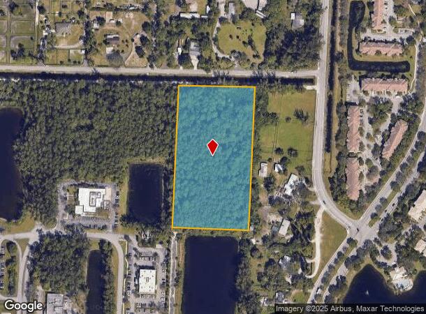
Property Record
State Road 80, County Of Palm Beach, FL 33470

NEARBY LISTINGS FOR SALE OR LEASE
Property Detail
State Road 80
West Palm Beach-Boca Raton-Delray Beach, FL
Loxahatchee Groves
72-41-43-17-01-901-0080
LOXAHATCHEE GROVES TR 1 (LESS E 360 FT & S 1514 FT) BLK K
Vacantlandnec
Palm Beach
AE
Florida
12099C0561F
6.30 AC
2024
Palm Bch Cty Outlying
2025
South Florida
007844
DEMOGRAPHICS near State Road 80
1 Mile
3 Mile
5 Mile
2024 Total Population
4,765
64,539
117,665
2029 Population
4,823
65,766
120,124
Pop Growth 2024-2029
+ 1.22%
+ 1.90%
+ 2.09%
Average Age
40
39
40
2024 Total Households
1,625
21,896
40,294
HH Growth 2024-2029
+ 0.37%
+ 1.26%
+ 1.46%
Median Household Inc
$99,338
$91,959
$95,101
Avg Household Size
2.80
2.80
2.80
2024 Avg HH Vehicles
2.00
2.00
2.00
Median Home Value
$412,027
$379,479
$407,030
Median Year Built
1996
1989
1993
Nearby Places
Map Layers
Map Styles
 Street
 Aerial
- Restaurants
- Banks
- Shops
- Fitness
- Groceries
PUBLIC TRANSPORTATION
AIRPORT
Palm Beach International
DRIVE
WALK
Distance
Palm Beach International
18 min
10.2 mi
Freight Ports
Port of Palm Beach
DRIVE
WALK
Distance
Port of Palm Beach
32 min
17.8 mi
SALE & LEASE HISTORY
LISTING DATE
SALE/LEASE

Sep 18, 2017
For Sale
Jul 23, 2021
For Sale
Apr 01, 2017
For Sale
Nearby Properties
Address
Land Use
TOTAL SIZE
Lot Size
Zoning
Address
Land Use
TOTAL SIZE
Lot Size
Zoning
398,622 SF
21.62 AC
RM-18
Address
Land Use
TOTAL SIZE
Lot Size
Zoning
669,818 SF
42.79 AC
IL
Address
Land Use
TOTAL SIZE
Lot Size
Zoning
349,316 SF
49.95 AC
CG
Address
Land Use
TOTAL SIZE
Lot Size
Zoning
346,161 SF
17.21 AC
PUD
Address
Land Use
TOTAL SIZE
Lot Size
Zoning
318,687 SF
29.98 AC
RM-9
Address
Land Use
TOTAL SIZE
Lot Size
Zoning
286,092 SF
11.62 AC
PUD
Address
Land Use
TOTAL SIZE
Lot Size
Zoning
159,302 SF
29.36 AC
Address
Land Use
TOTAL SIZE
Lot Size
Zoning
302,692 SF
55 AC
PO
Address
Land Use
TOTAL SIZE
Lot Size
Zoning
243,076 SF
15.47 AC
RM-18
Address
Land Use
TOTAL SIZE
Lot Size
Zoning
255,345 SF
15.34 AC
IPF
Address
Land Use
TOTAL SIZE
Lot Size
Zoning
190,294 SF
18.71 AC
PUD
Address
Land Use
TOTAL SIZE
Lot Size
Zoning
353,604 SF
58.45 AC
PUD
Address
Land Use
TOTAL SIZE
Lot Size
Zoning
116,424 SF
13.28 AC
PUD
Address
Land Use
TOTAL SIZE
Lot Size
Zoning
116,601 SF
13.94 AC
CG
Address
Land Use
TOTAL SIZE
Lot Size
Zoning
114,960 SF
11.71 AC
PUD
Address
Land Use
TOTAL SIZE
Lot Size
Zoning
149,934 SF
3.47 AC
CG
Address
Land Use
TOTAL SIZE
Lot Size
Zoning
129,117 SF
12.62 AC
CG
Address
Land Use
TOTAL SIZE
Lot Size
Zoning
114,658 SF
14.99 AC
CG
Address
Land Use
TOTAL SIZE
Lot Size
Zoning
156,427 SF
13.79 AC
PUD
Address
Land Use
TOTAL SIZE
Lot Size
Zoning
81,309 SF
22.90 AC
CO
Address
Land Use
TOTAL SIZE
Lot Size
Zoning
94,041 SF
21.56 AC
PUD
Address
Land Use
TOTAL SIZE
Lot Size
Zoning
152,387 SF
8.46 AC
IL
Address
Land Use
TOTAL SIZE
Lot Size
Zoning
124,261 SF
18.22 AC
PUD
Address
Land Use
TOTAL SIZE
Lot Size
Zoning
85,077 SF
4.10 AC
MXD
Address
Land Use
TOTAL SIZE
Lot Size
Zoning
180,760 SF
30 AC
PO
Address
Land Use
TOTAL SIZE
Lot Size
Zoning
124,420 SF
6.47 AC
IL
Address
Land Use
TOTAL SIZE
Lot Size
Zoning
75,077 SF
6.40 AC
RMU
Address
Land Use
TOTAL SIZE
Lot Size
Zoning
203,668 SF
19.18 AC
CG
Address
Land Use
TOTAL SIZE
Lot Size
Zoning
54,192 SF
74.82 AC
AR
Address
Land Use
TOTAL SIZE
Lot Size
Zoning
79,746 SF
10.99 AC
CG
The World's #1 Commercial Real Estate Marketplace
Connect with us
© 2025 CoStar Group
The information above has been obtained from sources believed reliable. While we do not doubt its accuracy we have not verified it and make no guarantee, warranty or representation about it. It is your responsibility to independently confirm its accuracy and completeness. Any projections, opinions, assumptions, or estimates used are for example only and do not represent the current or future performance of the property. The value of this transaction to you depends on tax and other factors which should be evaluated by your tax, financial, and legal advisors. You and your advisors should conduct a careful, independent investigation of the property to determine to your satisfaction the suitability of the property for your needs.