Property Record
State Route 11, Brushton, NY 12916
NEARBY LISTINGS FOR SALE OR LEASE
-
-
View all Brushton listings for sale on LoopNet.com
Property Detail
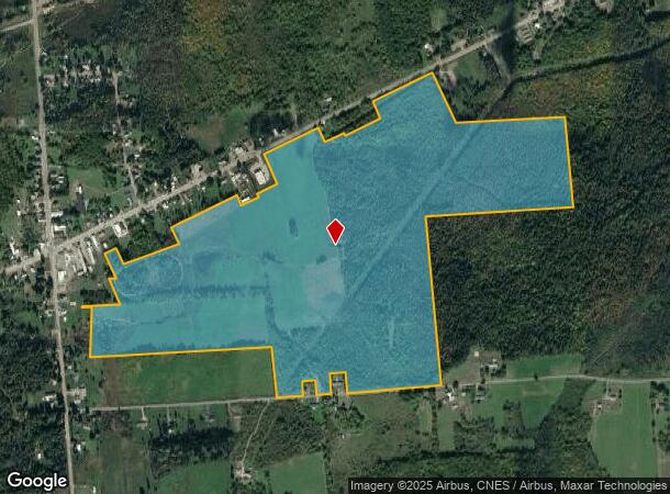
State Route 11
Other Market Areas
ROAD HALL ROAD LAPAGE
Malone, NY
Franklin
165089-121-000-0003-043-200-0000
New York
Agriculturalland
43.200
2025
197.12 AC
2024
Upstate New York Area
950301
DEMOGRAPHICS near State Route 11
1 Mile
3 Mile
5 Mile
2024 Total Population
463
2,032
3,537
2029 Population
446
1,958
3,437
Pop Growth 2024-2029
(3.67%)
(3.64%)
(2.83%)
Average Age
40
40
40
2024 Total Households
196
859
1,459
HH Growth 2024-2029
(3.57%)
(3.84%)
(3.15%)
Median Household Inc
$50,556
$50,602
$52,483
Avg Household Size
2.30
2.30
2.40
2024 Avg HH Vehicles
2.00
2.00
2.00
Median Home Value
$147,368
$146,230
$132,758
Median Year Built
1960
1960
1965
Nearby Places
- Restaurants
- Banks
- Shops
- Fitness
- Groceries
Nearby Properties
Address
Land Use
TOTAL SIZE
Lot Size
Zoning
Address
Land Use
TOTAL SIZE
Lot Size
Zoning
58,060 SF
89.18 AC
Address
Land Use
TOTAL SIZE
Lot Size
Zoning
390.06 AC
02 - SINGL
Address
Land Use
TOTAL SIZE
Lot Size
Zoning
9,360 SF
3.50 AC
Address
Land Use
TOTAL SIZE
Lot Size
Zoning
Address
Land Use
TOTAL SIZE
Lot Size
Zoning
1,680 SF
53.32 AC
Address
Land Use
TOTAL SIZE
Lot Size
Zoning
9,100 SF
1.66 AC
Address
Land Use
TOTAL SIZE
Lot Size
Zoning
Address
Land Use
TOTAL SIZE
Lot Size
Zoning
2,951 SF
0.60 AC
Address
Land Use
TOTAL SIZE
Lot Size
Zoning
6,120 SF
0.50 AC
Address
Land Use
TOTAL SIZE
Lot Size
Zoning
5,576 SF
3 AC
Address
Land Use
TOTAL SIZE
Lot Size
Zoning
3,136 SF
1.25 AC
Address
Land Use
TOTAL SIZE
Lot Size
Zoning
2,644 SF
15.10 AC
Address
Land Use
TOTAL SIZE
Lot Size
Zoning
Address
Land Use
TOTAL SIZE
Lot Size
Zoning
3,584 SF
1.15 AC
Address
Land Use
TOTAL SIZE
Lot Size
Zoning
573.04 AC
Address
Land Use
TOTAL SIZE
Lot Size
Zoning
Address
Land Use
TOTAL SIZE
Lot Size
Zoning
1,224 SF
18.25 AC
Address
Land Use
TOTAL SIZE
Lot Size
Zoning
2,884 SF
10 AC
Address
Land Use
TOTAL SIZE
Lot Size
Zoning
3,924 SF
3.10 AC
Address
Land Use
TOTAL SIZE
Lot Size
Zoning
Address
Land Use
TOTAL SIZE
Lot Size
Zoning
6,448 SF
0.85 AC
Address
Land Use
TOTAL SIZE
Lot Size
Zoning
2,362 SF
1.60 AC
Address
Land Use
TOTAL SIZE
Lot Size
Zoning
22,464 SF
1.16 AC
Address
Land Use
TOTAL SIZE
Lot Size
Zoning
3,120 SF
2.11 AC
Address
Land Use
TOTAL SIZE
Lot Size
Zoning
533 SF
5.20 AC
Address
Land Use
TOTAL SIZE
Lot Size
Zoning
1,568 SF
45.70 AC
Address
Land Use
TOTAL SIZE
Lot Size
Zoning
1,802 SF
24 AC
N00
Address
Land Use
TOTAL SIZE
Lot Size
Zoning
2,348 SF
1.74 AC
Address
Land Use
TOTAL SIZE
Lot Size
Zoning
7,055 SF
5 AC
Address
Land Use
TOTAL SIZE
Lot Size
Zoning
0.01 AC
The World's #1 Commercial Real Estate Marketplace
Connect with us
© 2025 CoStar Group
The information above has been obtained from sources believed reliable. While we do not doubt its accuracy we have not verified it and make no guarantee, warranty or representation about it. It is your responsibility to independently confirm its accuracy and completeness. Any projections, opinions, assumptions, or estimates used are for example only and do not represent the current or future performance of the property. The value of this transaction to you depends on tax and other factors which should be evaluated by your tax, financial, and legal advisors. You and your advisors should conduct a careful, independent investigation of the property to determine to your satisfaction the suitability of the property for your needs.