Property Record
State Route 15, Hopatcong, NJ 07843
NEARBY LISTINGS FOR SALE OR LEASE
Property Detail
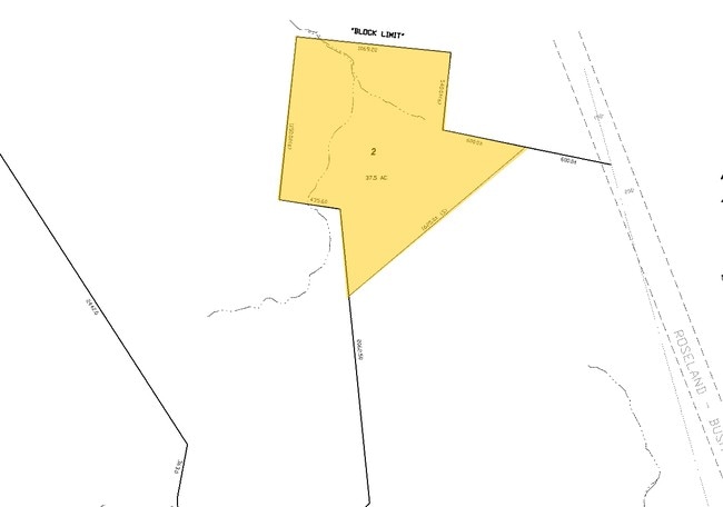
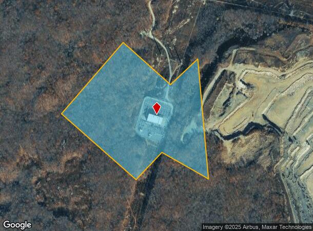
State Route 15
12-70001-0000-00002
Sussex
Commercialnec
New Jersey
X
2
34037C0410E
17.73 AC
2024
Sussex County
2025
Northern New Jersey
374700
Newark, NJ-PA
DEMOGRAPHICS near State Route 15
1 Mile
3 Mile
5 Mile
2024 Total Population
581
21,911
48,400
2029 Population
589
22,208
48,928
Pop Growth 2024-2029
+ 1.38%
+ 1.36%
+ 1.09%
Average Age
42
43
43
2024 Total Households
213
8,450
18,392
HH Growth 2024-2029
+ 1.41%
+ 1.38%
+ 1.10%
Median Household Inc
$149,264
$127,581
$114,695
Avg Household Size
2.70
2.60
2.60
2024 Avg HH Vehicles
2.00
2.00
2.00
Median Home Value
$397,886
$383,666
$366,094
Median Year Built
1978
1963
1966
Nearby Places
Map Layers
Map Styles
 Street
 Aerial
- Restaurants
- Banks
- Shops
- Fitness
- Groceries
PUBLIC TRANSPORTATION
COMMUTER RAIL
Mount Arlington (Montclair-Boonton Line - NJ Transit Commuter Rail (NJ Transit), Morris & Essex Morristown Line - NJ Transit Commuter Rail (NJ Transit))
DRIVE
WALK
Distance
Mount Arlington (Montclair-Boonton Line - NJ Transit Commuter Rail (NJ Transit), Morris & Essex Morristown Line - NJ Transit Commuter Rail (NJ Transit))
21 min
9.9 mi
Freight Ports
Maher Terminal
DRIVE
WALK
Distance
Maher Terminal
62 min
40.9 mi
Nearby Properties
Address
Land Use
TOTAL SIZE
Lot Size
Zoning
Address
Land Use
TOTAL SIZE
Lot Size
Zoning
765.45 AC
M2
Address
Land Use
TOTAL SIZE
Lot Size
Zoning
8,664 SF
19.35 AC
R3
Address
Land Use
TOTAL SIZE
Lot Size
Zoning
2,443 SF
6.73 AC
RAC2
Address
Land Use
TOTAL SIZE
Lot Size
Zoning
17.90 AC
R-30
Address
Land Use
TOTAL SIZE
Lot Size
Zoning
47,786 SF
8.60 AC
TCCO
Address
Land Use
TOTAL SIZE
Lot Size
Zoning
11.27 AC
C-1
Address
Land Use
TOTAL SIZE
Lot Size
Zoning
48,238 SF
25 AC
OSGU
Address
Land Use
TOTAL SIZE
Lot Size
Zoning
14,967 SF
82.85 AC
RR
Address
Land Use
TOTAL SIZE
Lot Size
Zoning
17,324 SF
1.50 AC
TCC
Address
Land Use
TOTAL SIZE
Lot Size
Zoning
320 SF
3.45 AC
C-1
Address
Land Use
TOTAL SIZE
Lot Size
Zoning
21,525 SF
5.70 AC
C-2
Address
Land Use
TOTAL SIZE
Lot Size
Zoning
0.81 AC
R-30
Address
Land Use
TOTAL SIZE
Lot Size
Zoning
22,528 SF
7.50 AC
RR
Address
Land Use
TOTAL SIZE
Lot Size
Zoning
13,912 SF
9.62 AC
C-1
Address
Land Use
TOTAL SIZE
Lot Size
Zoning
13,220 SF
0.97 AC
RR
Address
Land Use
TOTAL SIZE
Lot Size
Zoning
1,800 SF
396.08 AC
RC
Address
Land Use
TOTAL SIZE
Lot Size
Zoning
44,554 SF
6.12 AC
C1
Address
Land Use
TOTAL SIZE
Lot Size
Zoning
36,667 SF
1.75 AC
TCC
Address
Land Use
TOTAL SIZE
Lot Size
Zoning
14.68 AC
R1
Address
Land Use
TOTAL SIZE
Lot Size
Zoning
16,775 SF
34.51 AC
RC
Address
Land Use
TOTAL SIZE
Lot Size
Zoning
372.04 AC
OSGU
Address
Land Use
TOTAL SIZE
Lot Size
Zoning
11,000 SF
6.62 AC
C-2
Address
Land Use
TOTAL SIZE
Lot Size
Zoning
12,050 SF
1.05 AC
C-2
Address
Land Use
TOTAL SIZE
Lot Size
Zoning
19,500 SF
4.75 AC
C-2
Address
Land Use
TOTAL SIZE
Lot Size
Zoning
11 AC
R-30
Address
Land Use
TOTAL SIZE
Lot Size
Zoning
22,680 SF
3.59 AC
C-2
Address
Land Use
TOTAL SIZE
Lot Size
Zoning
20,680 SF
1.75 AC
TCC
Address
Land Use
TOTAL SIZE
Lot Size
Zoning
21,970 SF
0.48 AC
TCC
Address
Land Use
TOTAL SIZE
Lot Size
Zoning
3,798 SF
26.96 AC
ED
The World's #1 Commercial Real Estate Marketplace
Connect with us
© 2026 CoStar Group
The information above has been obtained from sources believed reliable. While we do not doubt its accuracy we have not verified it and make no guarantee, warranty or representation about it. It is your responsibility to independently confirm its accuracy and completeness. Any projections, opinions, assumptions, or estimates used are for example only and do not represent the current or future performance of the property. The value of this transaction to you depends on tax and other factors which should be evaluated by your tax, financial, and legal advisors. You and your advisors should conduct a careful, independent investigation of the property to determine to your satisfaction the suitability of the property for your needs.