Property Record
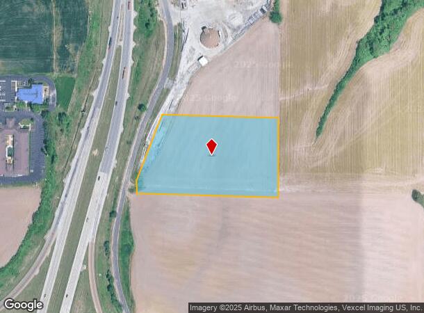
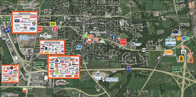
State Rt 158, Lebanon, IL 62254
This Property Is For Sale
NEARBY LISTINGS FOR SALE OR LEASE
Property Detail
State Rt 158
St. Louis
Ofallon Twp
St. Louis, MO-IL
OFALLON TWP SEC 34 LOT/SEC-34-SUBL/TWP-2N-BLK/RG-7W PT LOT 4 PT NW A02463681 A02463681
04-34.0-100-009
St. Clair
Agriculturalland
Illinois
2024
4
2024
4.62 AC
504359
Illinois
DEMOGRAPHICS near State Rt 158
1 Mile
3 Mile
5 Mile
2024 Total Population
596
21,646
56,687
2029 Population
582
21,030
55,401
Pop Growth 2024-2029
(2.35%)
(2.85%)
(2.27%)
Average Age
43
39
39
2024 Total Households
274
8,640
21,803
HH Growth 2024-2029
(2.55%)
(3.01%)
(2.34%)
Median Household Inc
$71,785
$89,583
$100,574
Avg Household Size
2.10
2.50
2.50
2024 Avg HH Vehicles
2.00
2.00
2.00
Median Home Value
$235,714
$255,574
$271,977
Median Year Built
1987
1987
1994
Nearby Places
Map Layers
Map Styles
 Street
 Aerial
- Restaurants
- Banks
- Shops
- Fitness
- Groceries
PUBLIC TRANSPORTATION
COMMUTER RAIL
Shiloh-Scott (Lambert Airport Shiloh-Scott - St. Louis MetroLink (MetroLink))
DRIVE
WALK
Distance
Shiloh-Scott (Lambert Airport Shiloh-Scott - St. Louis MetroLink (MetroLink))
9 min
4.3 mi
College (Lambert Airport Shiloh-Scott - St. Louis MetroLink (MetroLink))
DRIVE
WALK
Distance
College (Lambert Airport Shiloh-Scott - St. Louis MetroLink (MetroLink))
14 min
7.6 mi
AIRPORT
Scott AFB/Midamerica St Louis
DRIVE
WALK
Distance
Scott AFB/Midamerica St Louis
18 min
7.8 mi
St Louis Lambert International
DRIVE
WALK
Distance
St Louis Lambert International
47 min
33.4 mi
Freight Ports
Port Milwaukee
DRIVE
WALK
Distance
Port Milwaukee
418 min
364.2 mi
Nearby Properties
Address
Land Use
TOTAL SIZE
Lot Size
Zoning
Address
Land Use
TOTAL SIZE
Lot Size
Zoning
70,515 SF
27.95 AC
Address
Land Use
TOTAL SIZE
Lot Size
Zoning
Address
Land Use
TOTAL SIZE
Lot Size
Zoning
10.08 AC
Address
Land Use
TOTAL SIZE
Lot Size
Zoning
Address
Land Use
TOTAL SIZE
Lot Size
Zoning
8,141 SF
16.74 AC
Address
Land Use
TOTAL SIZE
Lot Size
Zoning
9.63 AC
Address
Land Use
TOTAL SIZE
Lot Size
Zoning
81.90 AC
Address
Land Use
TOTAL SIZE
Lot Size
Zoning
Address
Land Use
TOTAL SIZE
Lot Size
Zoning
37,197 SF
6.20 AC
Address
Land Use
TOTAL SIZE
Lot Size
Zoning
37,201 SF
4.52 AC
Address
Land Use
TOTAL SIZE
Lot Size
Zoning
125,576 SF
3.48 AC
Address
Land Use
TOTAL SIZE
Lot Size
Zoning
Address
Land Use
TOTAL SIZE
Lot Size
Zoning
28,329 SF
3.08 AC
Address
Land Use
TOTAL SIZE
Lot Size
Zoning
Address
Land Use
TOTAL SIZE
Lot Size
Zoning
4.26 AC
Address
Land Use
TOTAL SIZE
Lot Size
Zoning
56,415 SF
5.77 AC
Address
Land Use
TOTAL SIZE
Lot Size
Zoning
30,000 SF
3.54 AC
Address
Land Use
TOTAL SIZE
Lot Size
Zoning
Address
Land Use
TOTAL SIZE
Lot Size
Zoning
Address
Land Use
TOTAL SIZE
Lot Size
Zoning
20.34 AC
Address
Land Use
TOTAL SIZE
Lot Size
Zoning
Address
Land Use
TOTAL SIZE
Lot Size
Zoning
Address
Land Use
TOTAL SIZE
Lot Size
Zoning
29,196 SF
6.16 AC
Address
Land Use
TOTAL SIZE
Lot Size
Zoning
5.60 AC
Address
Land Use
TOTAL SIZE
Lot Size
Zoning
37,015 SF
8.44 AC
Address
Land Use
TOTAL SIZE
Lot Size
Zoning
2.97 AC
Address
Land Use
TOTAL SIZE
Lot Size
Zoning
15.69 AC
Address
Land Use
TOTAL SIZE
Lot Size
Zoning
Address
Land Use
TOTAL SIZE
Lot Size
Zoning
4,608 SF
4.75 AC
Address
Land Use
TOTAL SIZE
Lot Size
Zoning
1.61 AC
The World's #1 Commercial Real Estate Marketplace
Connect with us
© 2026 CoStar Group
The information above has been obtained from sources believed reliable. While we do not doubt its accuracy we have not verified it and make no guarantee, warranty or representation about it. It is your responsibility to independently confirm its accuracy and completeness. Any projections, opinions, assumptions, or estimates used are for example only and do not represent the current or future performance of the property. The value of this transaction to you depends on tax and other factors which should be evaluated by your tax, financial, and legal advisors. You and your advisors should conduct a careful, independent investigation of the property to determine to your satisfaction the suitability of the property for your needs.