Property Record
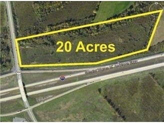
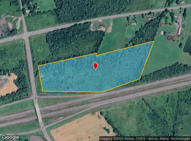
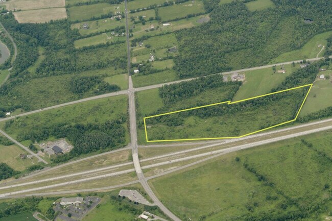
State Route 30A, Schoharie, NY 12157
NEARBY LISTINGS FOR SALE OR LEASE
Property Detail
State Route 30A
434289-048-000-0004-028-000-0000
Schoharie
Commercialacreage
New York
X
28.000
36095C0183E
28.10 AC
2025
Schoharie County
2024
Albany/Schenectady/Troy
740100
Albany-Schenectady-Troy, NY
DEMOGRAPHICS near State Route 30A
1 Mile
3 Mile
5 Mile
2024 Total Population
369
1,997
6,008
2029 Population
367
1,996
6,045
Pop Growth 2024-2029
(0.54%)
(0.05%)
+ 0.62%
Average Age
43
44
44
2024 Total Households
157
858
2,539
HH Growth 2024-2029
(0.64%)
(0.23%)
+ 0.43%
Median Household Inc
$57,142
$58,289
$67,829
Avg Household Size
2.30
2.30
2.30
2024 Avg HH Vehicles
2.00
2.00
2.00
Median Home Value
$182,221
$186,234
$180,336
Median Year Built
1955
1956
1965
Nearby Places
- Restaurants
- Banks
- Shops
- Fitness
- Groceries
PUBLIC TRANSPORTATION
AIRPORT
Albany International
DRIVE
WALK
Distance
Albany International
46 min
32.9 mi
Freight Ports
Albany, NY Port
DRIVE
WALK
Distance
Albany, NY Port
45 min
36.2 mi
SALE & LEASE HISTORY
LISTING DATE
SALE/LEASE

Sep 24, 2016
For Sale
Oct 30, 2020
For Sale
Nearby Properties
Address
Land Use
TOTAL SIZE
Lot Size
Zoning
Address
Land Use
TOTAL SIZE
Lot Size
Zoning
181,478 SF
41.44 AC
R1
Address
Land Use
TOTAL SIZE
Lot Size
Zoning
13,127 SF
3.67 AC
H
Address
Land Use
TOTAL SIZE
Lot Size
Zoning
79,955 SF
6.70 AC
C
Address
Land Use
TOTAL SIZE
Lot Size
Zoning
31,048 SF
63.30 AC
A
Address
Land Use
TOTAL SIZE
Lot Size
Zoning
27,600 SF
5.50 AC
C
Address
Land Use
TOTAL SIZE
Lot Size
Zoning
13,912 SF
4.11 AC
A
Address
Land Use
TOTAL SIZE
Lot Size
Zoning
3,262 SF
41.10 AC
Address
Land Use
TOTAL SIZE
Lot Size
Zoning
41,600 SF
4.20 AC
Address
Land Use
TOTAL SIZE
Lot Size
Zoning
4,000 SF
1.62 AC
Address
Land Use
TOTAL SIZE
Lot Size
Zoning
14,408 SF
1.94 AC
PD
Address
Land Use
TOTAL SIZE
Lot Size
Zoning
7,940 SF
0.90 AC
H
Address
Land Use
TOTAL SIZE
Lot Size
Zoning
4,209 SF
12 AC
I
Address
Land Use
TOTAL SIZE
Lot Size
Zoning
Address
Land Use
TOTAL SIZE
Lot Size
Zoning
32.05 AC
Address
Land Use
TOTAL SIZE
Lot Size
Zoning
25.20 AC
A
Address
Land Use
TOTAL SIZE
Lot Size
Zoning
3,304 SF
124.60 AC
R2
Address
Land Use
TOTAL SIZE
Lot Size
Zoning
20.74 AC
A
Address
Land Use
TOTAL SIZE
Lot Size
Zoning
14.92 AC
Address
Land Use
TOTAL SIZE
Lot Size
Zoning
1.10 AC
I
Address
Land Use
TOTAL SIZE
Lot Size
Zoning
1,280 SF
2.02 AC
Address
Land Use
TOTAL SIZE
Lot Size
Zoning
18,958 SF
5.40 AC
Address
Land Use
TOTAL SIZE
Lot Size
Zoning
3,450 SF
7.30 AC
I
Address
Land Use
TOTAL SIZE
Lot Size
Zoning
3,192 SF
1.46 AC
C
Address
Land Use
TOTAL SIZE
Lot Size
Zoning
1,980 SF
0.55 AC
C
Address
Land Use
TOTAL SIZE
Lot Size
Zoning
2,568 SF
1.46 AC
C
Address
Land Use
TOTAL SIZE
Lot Size
Zoning
6,500 SF
3.52 AC
Address
Land Use
TOTAL SIZE
Lot Size
Zoning
2,888 SF
0.58 AC
C
Address
Land Use
TOTAL SIZE
Lot Size
Zoning
852 SF
16 AC
Address
Land Use
TOTAL SIZE
Lot Size
Zoning
8.30 AC
R1
Address
Land Use
TOTAL SIZE
Lot Size
Zoning
185.80 AC
A
The World's #1 Commercial Real Estate Marketplace
Connect with us
© 2025 CoStar Group
The information above has been obtained from sources believed reliable. While we do not doubt its accuracy we have not verified it and make no guarantee, warranty or representation about it. It is your responsibility to independently confirm its accuracy and completeness. Any projections, opinions, assumptions, or estimates used are for example only and do not represent the current or future performance of the property. The value of this transaction to you depends on tax and other factors which should be evaluated by your tax, financial, and legal advisors. You and your advisors should conduct a careful, independent investigation of the property to determine to your satisfaction the suitability of the property for your needs.