Property Record
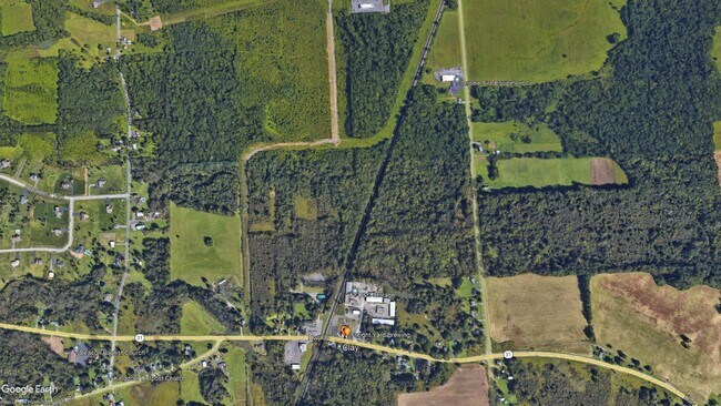
State Route 31, Clay, NY 13041
NEARBY LISTINGS FOR SALE OR LEASE
Property Detail
State Route 31
Syracuse, NY
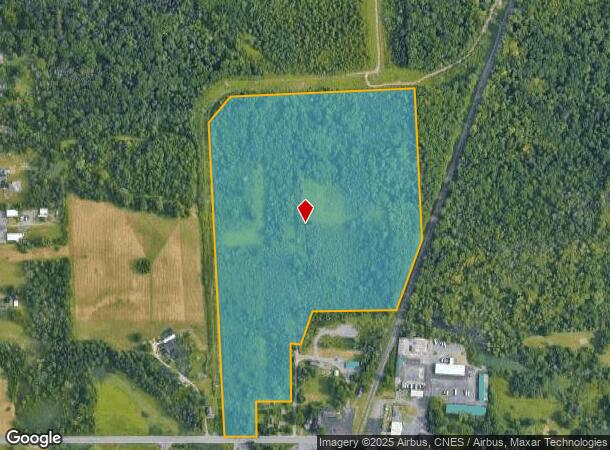
LAND OF MELVIN LT 2 0162216
312489-046-000-0001-038-001-0000
Onondaga
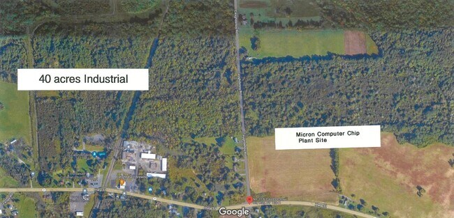
Agriculturalland
New York
X
38.001
36067C0083F
39.61 AC
2025
NE Outer Onondaga County
2024
Syracuse
011241
DEMOGRAPHICS near State Route 31
1 Mile
3 Mile
5 Mile
2024 Total Population
4,924
28,061
68,345
2029 Population
4,839
27,344
66,639
Pop Growth 2024-2029
(1.73%)
(2.56%)
(2.50%)
Average Age
41
42
42
2024 Total Households
2,276
11,489
28,484
HH Growth 2024-2029
(2.02%)
(2.75%)
(2.69%)
Median Household Inc
$70,824
$83,307
$78,212
Avg Household Size
2.10
2.40
2.30
2024 Avg HH Vehicles
2.00
2.00
2.00
Median Home Value
$182,965
$197,084
$182,149
Median Year Built
1988
1985
1978
Nearby Places
Map Layers
Map Styles
 Street
 Aerial
- Restaurants
- Banks
- Shops
- Fitness
- Groceries
PUBLIC TRANSPORTATION
AIRPORT
Syracuse Hancock International
DRIVE
WALK
Distance
Syracuse Hancock International
14 min
9.6 mi
Freight Ports
Albany, NY Port
DRIVE
WALK
Distance
Albany, NY Port
179 min
150.0 mi
SALE & LEASE HISTORY
LISTING DATE
SALE/LEASE

Nov 11, 2022
For Sale
Mar 08, 2024
For Sale
Nearby Properties
Address
Land Use
TOTAL SIZE
Lot Size
Zoning
Address
Land Use
TOTAL SIZE
Lot Size
Zoning
271,263 SF
77.30 AC
Address
Land Use
TOTAL SIZE
Lot Size
Zoning
17,436 SF
98.89 AC
06000
Address
Land Use
TOTAL SIZE
Lot Size
Zoning
16,630 SF
10.16 AC
Address
Land Use
TOTAL SIZE
Lot Size
Zoning
43,968 SF
1.95 AC
Address
Land Use
TOTAL SIZE
Lot Size
Zoning
3,724 SF
56.89 AC
N00
Address
Land Use
TOTAL SIZE
Lot Size
Zoning
12,220 SF
5.86 AC
Address
Land Use
TOTAL SIZE
Lot Size
Zoning
116,020 SF
15.72 AC
PUD
Address
Land Use
TOTAL SIZE
Lot Size
Zoning
42,210 SF
62.23 AC
N00
Address
Land Use
TOTAL SIZE
Lot Size
Zoning
26,445 SF
3.95 AC
Address
Land Use
TOTAL SIZE
Lot Size
Zoning
952 SF
3.81 AC
Address
Land Use
TOTAL SIZE
Lot Size
Zoning
16,630 SF
2.66 AC
Address
Land Use
TOTAL SIZE
Lot Size
Zoning
16,630 SF
3.95 AC
Address
Land Use
TOTAL SIZE
Lot Size
Zoning
39,055 SF
28.38 AC
Address
Land Use
TOTAL SIZE
Lot Size
Zoning
17,760 SF
4.54 AC
CG
Address
Land Use
TOTAL SIZE
Lot Size
Zoning
30,971 SF
4.02 AC
CG
Address
Land Use
TOTAL SIZE
Lot Size
Zoning
4,096 SF
3.06 AC
Address
Land Use
TOTAL SIZE
Lot Size
Zoning
8,068 SF
3.33 AC
Address
Land Use
TOTAL SIZE
Lot Size
Zoning
2,314 SF
96.17 AC
06000
Address
Land Use
TOTAL SIZE
Lot Size
Zoning
21,224 SF
3 AC
CG
Address
Land Use
TOTAL SIZE
Lot Size
Zoning
51,294 SF
6.25 AC
Address
Land Use
TOTAL SIZE
Lot Size
Zoning
3,600 SF
1.17 AC
Address
Land Use
TOTAL SIZE
Lot Size
Zoning
10,540 SF
4.59 AC
CG
Address
Land Use
TOTAL SIZE
Lot Size
Zoning
6,200 SF
117.28 AC
06 - INDUS
Address
Land Use
TOTAL SIZE
Lot Size
Zoning
Address
Land Use
TOTAL SIZE
Lot Size
Zoning
13,844 SF
3.49 AC
Address
Land Use
TOTAL SIZE
Lot Size
Zoning
18,498 SF
1.07 AC
Address
Land Use
TOTAL SIZE
Lot Size
Zoning
7,200 SF
71.08 AC
Address
Land Use
TOTAL SIZE
Lot Size
Zoning
12,312 SF
40.32 AC
05 - COMME
Address
Land Use
TOTAL SIZE
Lot Size
Zoning
54,523 SF
4.72 AC
Address
Land Use
TOTAL SIZE
Lot Size
Zoning
864 SF
98.47 AC
01 - NOT Z
The World's #1 Commercial Real Estate Marketplace
Connect with us
© 2026 CoStar Group
The information above has been obtained from sources believed reliable. While we do not doubt its accuracy we have not verified it and make no guarantee, warranty or representation about it. It is your responsibility to independently confirm its accuracy and completeness. Any projections, opinions, assumptions, or estimates used are for example only and do not represent the current or future performance of the property. The value of this transaction to you depends on tax and other factors which should be evaluated by your tax, financial, and legal advisors. You and your advisors should conduct a careful, independent investigation of the property to determine to your satisfaction the suitability of the property for your needs.