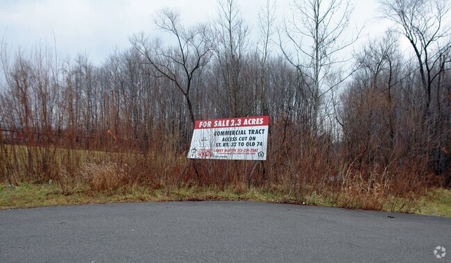
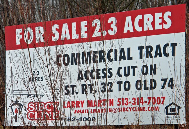
Property Record
State Route 32, Batavia, OH 45103

Property Detail
State Route 32
41-31-03I-318
CLERMONT
Residentialacreage
Ohio
B and X Area of moderate flood hazard, usually the area between the limits of the 100-year and 500-year floods.
0.14 AC
2025
Eastgate/Anderson Twp
2025
Cincinnati/Dayton
041002
Cincinnati, OH-KY-IN
NEARBY LISTINGS FOR SALE OR LEASE
DEMOGRAPHICS near State Route 32
1 mile
3 mile
5 mile
2025 Total Population
9,489
43,708
98,557
2030 Population
9,765
44,904
100,751
Pop Growth 2025-2030
+ 2.91%
+ 2.74%
+ 2.23%
Average Age
40
41
41
2025 Total Households
4,191
18,175
39,916
HH Growth 2025-2030
+ 3.25%
+ 2.94%
+ 2.47%
Median Household Inc
$71,522
$74,736
$81,281
Avg Household Size
2.20
2.30
2.40
2025 Avg HH Vehicles
2.00
2.00
2.00
Median Home Value
$276,758
$275,044
$288,687
Median Year Built
1992
1988
1986
Nearby Places
Map Layers
Map Styles
 Street
 Aerial
Layers
 Traffic
 Biking
Places
Listings with unknown addresses are not visible on the map
- Restaurants
- Banks
- Shops
- Fitness
- Groceries
PUBLIC TRANSPORTATION
AIRPORT
Cincinnati/Northern Kentucky International
Drive
Walk
Distance
Cincinnati/Northern Kentucky International
42 min
28.3 mi
Freight Ports
Port of Toledo
Drive
Walk
Distance
Port of Toledo
245 min
211.6 mi
Nearby Properties
Address
Land Use
TOTAL SIZE
Lot Size
Zoning
Address
Land Use
TOTAL SIZE
Lot Size
Zoning
7,560 SF
79.10 AC
Address
Land Use
TOTAL SIZE
Lot Size
Zoning
104,856 SF
46.13 AC
Address
Land Use
TOTAL SIZE
Lot Size
Zoning
50,382 SF
33.05 AC
Address
Land Use
TOTAL SIZE
Lot Size
Zoning
154,426 SF
35.05 AC
Address
Land Use
TOTAL SIZE
Lot Size
Zoning
Address
Land Use
TOTAL SIZE
Lot Size
Zoning
52,178 SF
5.98 AC
Address
Land Use
TOTAL SIZE
Lot Size
Zoning
4,938 SF
18.99 AC
Address
Land Use
TOTAL SIZE
Lot Size
Zoning
236,920 SF
18.94 AC
Address
Land Use
TOTAL SIZE
Lot Size
Zoning
49.15 AC
Address
Land Use
TOTAL SIZE
Lot Size
Zoning
88,932 SF
11.21 AC
Address
Land Use
TOTAL SIZE
Lot Size
Zoning
Address
Land Use
TOTAL SIZE
Lot Size
Zoning
56,080 SF
4.40 AC
Address
Land Use
TOTAL SIZE
Lot Size
Zoning
42,078 SF
58.22 AC
Address
Land Use
TOTAL SIZE
Lot Size
Zoning
14.24 AC
Address
Land Use
TOTAL SIZE
Lot Size
Zoning
78,145 SF
19.91 AC
Address
Land Use
TOTAL SIZE
Lot Size
Zoning
26,637 SF
6.97 AC
Address
Land Use
TOTAL SIZE
Lot Size
Zoning
26,498 SF
50.11 AC
Address
Land Use
TOTAL SIZE
Lot Size
Zoning
27.01 AC
Address
Land Use
TOTAL SIZE
Lot Size
Zoning
980 SF
5.01 AC
Address
Land Use
TOTAL SIZE
Lot Size
Zoning
70,456 SF
15.28 AC
Address
Land Use
TOTAL SIZE
Lot Size
Zoning
44,047 SF
3.37 AC
Address
Land Use
TOTAL SIZE
Lot Size
Zoning
79,064 SF
6.27 AC
Address
Land Use
TOTAL SIZE
Lot Size
Zoning
83,608 SF
4.45 AC
Address
Land Use
TOTAL SIZE
Lot Size
Zoning
11,442 SF
9.70 AC
Address
Land Use
TOTAL SIZE
Lot Size
Zoning
168,266 SF
105.07 AC
Address
Land Use
TOTAL SIZE
Lot Size
Zoning
59,730 SF
19.46 AC
Address
Land Use
TOTAL SIZE
Lot Size
Zoning
42,300 SF
10.72 AC
Address
Land Use
TOTAL SIZE
Lot Size
Zoning
70,489 SF
8.57 AC
Address
Land Use
TOTAL SIZE
Lot Size
Zoning
110,954 SF
9.61 AC
Address
Land Use
TOTAL SIZE
Lot Size
Zoning
396,288 SF
31.14 AC
The World's #1 Commercial Real Estate Marketplace
Connect with us
© 2026 CoStar Group
The information above has been obtained from sources believed reliable. While we do not doubt its accuracy we have not verified it and make no guarantee, warranty or representation about it. It is your responsibility to independently confirm its accuracy and completeness. Any projections, opinions, assumptions, or estimates used are for example only and do not represent the current or future performance of the property. The value of this transaction to you depends on tax and other factors which should be evaluated by your tax, financial, and legal advisors. You and your advisors should conduct a careful, independent investigation of the property to determine to your satisfaction the suitability of the property for your needs.