Property Record
State Route 43, Kent, OH 44240


Property Detail
State Route 43
Akron, OH
LOT 32 SD-20
04-032-00-00-051-007
PORTAGE
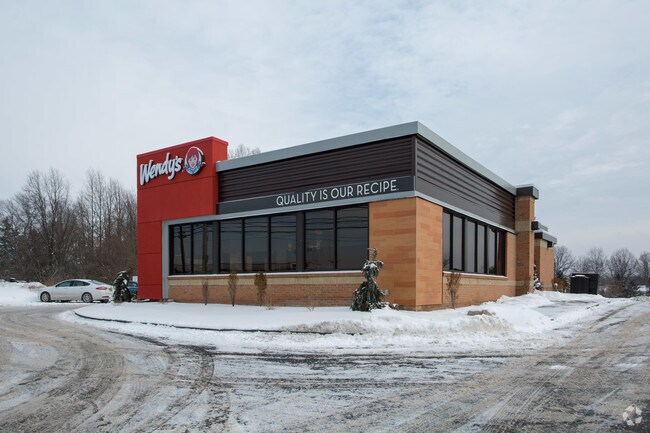
Restaurantdrivein
Ohio
B and X Area of moderate flood hazard, usually the area between the limits of the 100-year and 500-year floods.
32
2025
0.55 AC
2025
Portage County
601501
Cleveland
2,930 SF
NEARBY LISTINGS FOR SALE OR LEASE
DEMOGRAPHICS near State Route 43
1 mile
3 mile
5 mile
2025 Total Population
3,531
23,605
70,521
2030 Population
3,583
23,936
71,167
Pop Growth 2025-2030
+ 1.47%
+ 1.40%
+ 0.92%
Average Age
39
37
38
2025 Total Households
1,467
9,743
28,613
HH Growth 2025-2030
+ 1.57%
+ 1.44%
+ 1.04%
Median Household Inc
$80,345
$67,366
$67,742
Avg Household Size
2.40
2.30
2.20
2025 Avg HH Vehicles
2.00
2.00
2.00
Median Home Value
$234,925
$252,890
$241,257
Median Year Built
1992
1980
1973
Nearby Places
Map Layers
Map Styles
 Street
 Aerial
Transit
 Traffic
 Biking
Places
Listings with unknown addresses are not visible on the map
- Restaurants
- Banks
- Shops
- Fitness
- Groceries
PUBLIC TRANSPORTATION
AIRPORT
Akron-Canton Regional
Drive
Walk
Distance
Akron-Canton Regional
29 min
21.7 mi
Cleveland-Hopkins International
Drive
Walk
Distance
Cleveland-Hopkins International
68 min
45.4 mi
Nearby Properties
Address
Land Use
TOTAL SIZE
Lot Size
Zoning
Address
Land Use
TOTAL SIZE
Lot Size
Zoning
139,790 SF
102.12 AC
Address
Land Use
TOTAL SIZE
Lot Size
Zoning
183,977 SF
10.12 AC
Address
Land Use
TOTAL SIZE
Lot Size
Zoning
815,100 SF
66.78 AC
Address
Land Use
TOTAL SIZE
Lot Size
Zoning
173,811 SF
9.34 AC
Address
Land Use
TOTAL SIZE
Lot Size
Zoning
68,754 SF
25.80 AC
Address
Land Use
TOTAL SIZE
Lot Size
Zoning
179,055 SF
19.68 AC
Address
Land Use
TOTAL SIZE
Lot Size
Zoning
193,894 SF
24.63 AC
Address
Land Use
TOTAL SIZE
Lot Size
Zoning
310,705 SF
9.96 AC
Address
Land Use
TOTAL SIZE
Lot Size
Zoning
216,994 SF
10.94 AC
Address
Land Use
TOTAL SIZE
Lot Size
Zoning
161,806 SF
1.92 AC
Address
Land Use
TOTAL SIZE
Lot Size
Zoning
91,286 SF
0.60 AC
Address
Land Use
TOTAL SIZE
Lot Size
Zoning
125,410 SF
119.68 AC
Address
Land Use
TOTAL SIZE
Lot Size
Zoning
212,628 SF
27.25 AC
Address
Land Use
TOTAL SIZE
Lot Size
Zoning
168,889 SF
30.80 AC
Address
Land Use
TOTAL SIZE
Lot Size
Zoning
88,682 SF
11.55 AC
Address
Land Use
TOTAL SIZE
Lot Size
Zoning
68,649 SF
13.45 AC
Address
Land Use
TOTAL SIZE
Lot Size
Zoning
78,805 SF
9.13 AC
Address
Land Use
TOTAL SIZE
Lot Size
Zoning
250,693 SF
93.26 AC
Address
Land Use
TOTAL SIZE
Lot Size
Zoning
130,766 SF
16.45 AC
Address
Land Use
TOTAL SIZE
Lot Size
Zoning
62,390 SF
8.39 AC
Address
Land Use
TOTAL SIZE
Lot Size
Zoning
57,542 SF
9.44 AC
Address
Land Use
TOTAL SIZE
Lot Size
Zoning
67,107 SF
9.29 AC
Address
Land Use
TOTAL SIZE
Lot Size
Zoning
25.46 AC
Address
Land Use
TOTAL SIZE
Lot Size
Zoning
117,966 SF
5.81 AC
Address
Land Use
TOTAL SIZE
Lot Size
Zoning
60,316 SF
13.94 AC
Address
Land Use
TOTAL SIZE
Lot Size
Zoning
13,924 SF
10.93 AC
Address
Land Use
TOTAL SIZE
Lot Size
Zoning
138,154 SF
13.25 AC
Address
Land Use
TOTAL SIZE
Lot Size
Zoning
121,904 SF
10.53 AC
Address
Land Use
TOTAL SIZE
Lot Size
Zoning
110,238 SF
9.52 AC
Address
Land Use
TOTAL SIZE
Lot Size
Zoning
57,079 SF
7.66 AC
The World's #1 Commercial Real Estate Marketplace
Connect with us
© 2026 CoStar Group
The information above has been obtained from sources believed reliable. While we do not doubt its accuracy we have not verified it and make no guarantee, warranty or representation about it. It is your responsibility to independently confirm its accuracy and completeness. Any projections, opinions, assumptions, or estimates used are for example only and do not represent the current or future performance of the property. The value of this transaction to you depends on tax and other factors which should be evaluated by your tax, financial, and legal advisors. You and your advisors should conduct a careful, independent investigation of the property to determine to your satisfaction the suitability of the property for your needs.