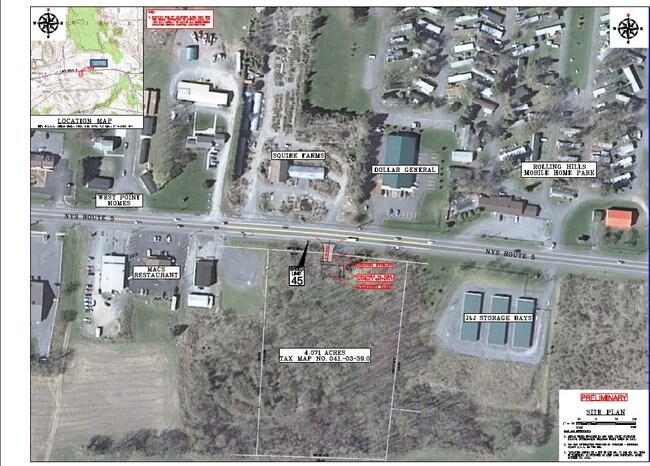
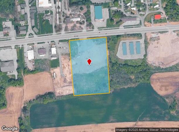
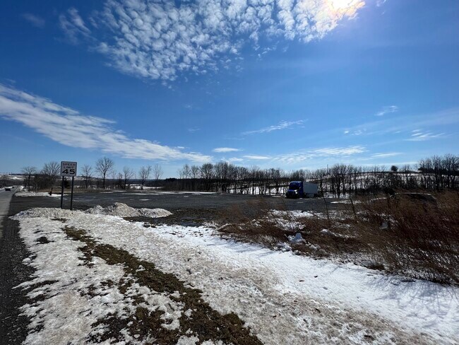
Property Record
State Route 5, Elbridge, NY 13060
NEARBY LISTINGS FOR SALE OR LEASE
Property Detail
State Route 5
Syracuse, NY
FLS 73 & 84
312889-041-000-0003-039-000-0000
Onondaga
Commercialacreage
New York
X
39.000
36067C0170F
4.40 AC
2025
W Outer Onondaga County
2024
Syracuse
012000
DEMOGRAPHICS near State Route 5
1 Mile
3 Mile
5 Mile
2024 Total Population
1,387
3,949
11,161
2029 Population
1,360
3,842
10,882
Pop Growth 2024-2029
(1.95%)
(2.71%)
(2.50%)
Average Age
44
45
45
2024 Total Households
559
1,637
4,586
HH Growth 2024-2029
(2.33%)
(3.05%)
(2.73%)
Median Household Inc
$43,416
$55,089
$73,149
Avg Household Size
2.30
2.30
2.40
2024 Avg HH Vehicles
2.00
2.00
2.00
Median Home Value
$143,939
$165,908
$196,630
Median Year Built
1978
1971
1971
Nearby Places
Map Layers
Map Styles
 Street
 Aerial
- Restaurants
- Banks
- Shops
- Fitness
- Groceries
PUBLIC TRANSPORTATION
AIRPORT
Syracuse Hancock International
DRIVE
WALK
Distance
Syracuse Hancock International
31 min
21.5 mi
SALE & LEASE HISTORY
LISTING DATE
SALE/LEASE

Nov 08, 2022
For Sale
Mar 28, 2017
For Sale
Mar 09, 2022
For Sale
Aug 13, 2022
For Lease
Nearby Properties
Address
Land Use
TOTAL SIZE
Lot Size
Zoning
Address
Land Use
TOTAL SIZE
Lot Size
Zoning
305,558 SF
28.34 AC
9
Address
Land Use
TOTAL SIZE
Lot Size
Zoning
4,200 SF
51.92 AC
06 - INDUS
Address
Land Use
TOTAL SIZE
Lot Size
Zoning
107,558 SF
57.12 AC
08 - GOVER
Address
Land Use
TOTAL SIZE
Lot Size
Zoning
185,026 SF
16.72 AC
9
Address
Land Use
TOTAL SIZE
Lot Size
Zoning
208 SF
46.88 AC
02 - SINGL
Address
Land Use
TOTAL SIZE
Lot Size
Zoning
52,922 SF
16.06 AC
07 - MIXED
Address
Land Use
TOTAL SIZE
Lot Size
Zoning
97,390 SF
31.92 AC
9
Address
Land Use
TOTAL SIZE
Lot Size
Zoning
10.90 AC
08 - GOVER
Address
Land Use
TOTAL SIZE
Lot Size
Zoning
Address
Land Use
TOTAL SIZE
Lot Size
Zoning
10,004 SF
4.03 AC
02 - SINGL
Address
Land Use
TOTAL SIZE
Lot Size
Zoning
20,252 SF
9.66 AC
02
Address
Land Use
TOTAL SIZE
Lot Size
Zoning
5,740 SF
2.36 AC
05 - COMME
Address
Land Use
TOTAL SIZE
Lot Size
Zoning
924 SF
11.39 AC
05 - COMME
Address
Land Use
TOTAL SIZE
Lot Size
Zoning
Address
Land Use
TOTAL SIZE
Lot Size
Zoning
11,295 SF
4.46 AC
04 - FARM
Address
Land Use
TOTAL SIZE
Lot Size
Zoning
92.89 AC
04 - FARM
Address
Land Use
TOTAL SIZE
Lot Size
Zoning
5,440 SF
10.45 AC
06 - INDUS
Address
Land Use
TOTAL SIZE
Lot Size
Zoning
4,668 SF
157.53 AC
04 - FARM
Address
Land Use
TOTAL SIZE
Lot Size
Zoning
6,932 SF
2.29 AC
05 - COMME
Address
Land Use
TOTAL SIZE
Lot Size
Zoning
10,976 SF
2.14 AC
05 - COMME
Address
Land Use
TOTAL SIZE
Lot Size
Zoning
26,298 SF
1.31 AC
15
Address
Land Use
TOTAL SIZE
Lot Size
Zoning
21,622 SF
5 AC
05 - COMME
Address
Land Use
TOTAL SIZE
Lot Size
Zoning
2,848 SF
1.10 AC
07 - MIXED
Address
Land Use
TOTAL SIZE
Lot Size
Zoning
25,831 SF
8.31 AC
07 - MIXED
Address
Land Use
TOTAL SIZE
Lot Size
Zoning
9,100 SF
1.11 AC
05 - COMME
Address
Land Use
TOTAL SIZE
Lot Size
Zoning
900 SF
0.46 AC
08 - GOVER
Address
Land Use
TOTAL SIZE
Lot Size
Zoning
Address
Land Use
TOTAL SIZE
Lot Size
Zoning
11,700 SF
1.66 AC
05 - COMME
Address
Land Use
TOTAL SIZE
Lot Size
Zoning
3.05 AC
02 - SINGL
Address
Land Use
TOTAL SIZE
Lot Size
Zoning
6,044 SF
2.42 AC
01 - NOT Z
The World's #1 Commercial Real Estate Marketplace
Connect with us
© 2026 CoStar Group
The information above has been obtained from sources believed reliable. While we do not doubt its accuracy we have not verified it and make no guarantee, warranty or representation about it. It is your responsibility to independently confirm its accuracy and completeness. Any projections, opinions, assumptions, or estimates used are for example only and do not represent the current or future performance of the property. The value of this transaction to you depends on tax and other factors which should be evaluated by your tax, financial, and legal advisors. You and your advisors should conduct a careful, independent investigation of the property to determine to your satisfaction the suitability of the property for your needs.