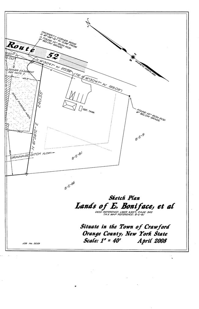
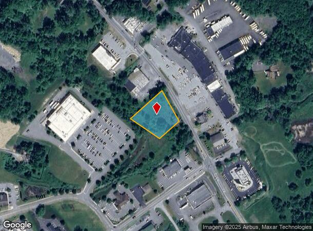
Property Record
State Route 52, T O Crawford, NY 12566
NEARBY LISTINGS FOR SALE OR LEASE
Property Detail
State Route 52
332600-008-000-0002-008.100-0000
Orange
Commercialacreage
New York
X
8.100
36071C0453E
0.86 AC
2024
Middletown
2024
Northern New Jersey
010902
New York-Jersey City-White Plains, NY-NJ
DEMOGRAPHICS near State Route 52
1 Mile
3 Mile
5 Mile
2024 Total Population
1,985
7,621
16,230
2029 Population
1,990
7,616
16,229
Pop Growth 2024-2029
+ 0.25%
(0.07%)
(0.01%)
Average Age
43
42
42
2024 Total Households
780
2,391
5,306
HH Growth 2024-2029
+ 0.26%
(0.13%)
(0.04%)
Median Household Inc
$83,152
$109,027
$109,849
Avg Household Size
2.40
2.60
2.70
2024 Avg HH Vehicles
2.00
2.00
2.00
Median Home Value
$274,619
$332,548
$338,041
Median Year Built
1958
1973
1974
Nearby Places
- Restaurants
- Banks
- Shops
- Fitness
- Groceries
PUBLIC TRANSPORTATION
AIRPORT
New York Stewart International
DRIVE
WALK
Distance
New York Stewart International
27 min
17.2 mi
Freight Ports
Port Newark Container Terminal
DRIVE
WALK
Distance
Port Newark Container Terminal
108 min
83.1 mi
Nearby Properties
Address
Land Use
TOTAL SIZE
Lot Size
Zoning
Address
Land Use
TOTAL SIZE
Lot Size
Zoning
1,944 SF
1,141 AC
RAG-4
Address
Land Use
TOTAL SIZE
Lot Size
Zoning
52.20 AC
Address
Land Use
TOTAL SIZE
Lot Size
Zoning
12.60 AC
Address
Land Use
TOTAL SIZE
Lot Size
Zoning
50,999 SF
5.70 AC
B
Address
Land Use
TOTAL SIZE
Lot Size
Zoning
6.20 AC
Address
Land Use
TOTAL SIZE
Lot Size
Zoning
1,862 SF
1.80 AC
07
Address
Land Use
TOTAL SIZE
Lot Size
Zoning
6.60 AC
Address
Land Use
TOTAL SIZE
Lot Size
Zoning
5,773 SF
118.50 AC
07
Address
Land Use
TOTAL SIZE
Lot Size
Zoning
8.50 AC
B
Address
Land Use
TOTAL SIZE
Lot Size
Zoning
37,250 SF
5 AC
Address
Land Use
TOTAL SIZE
Lot Size
Zoning
Address
Land Use
TOTAL SIZE
Lot Size
Zoning
11.90 AC
Address
Land Use
TOTAL SIZE
Lot Size
Zoning
6.60 AC
05 - COMME
Address
Land Use
TOTAL SIZE
Lot Size
Zoning
20,829 SF
3.40 AC
Address
Land Use
TOTAL SIZE
Lot Size
Zoning
16,000 SF
1.48 AC
FLX
Address
Land Use
TOTAL SIZE
Lot Size
Zoning
14.90 AC
RA07
Address
Land Use
TOTAL SIZE
Lot Size
Zoning
3.40 AC
Address
Land Use
TOTAL SIZE
Lot Size
Zoning
Address
Land Use
TOTAL SIZE
Lot Size
Zoning
1,911 SF
79 AC
RA07
Address
Land Use
TOTAL SIZE
Lot Size
Zoning
12,824 SF
1.30 AC
B
Address
Land Use
TOTAL SIZE
Lot Size
Zoning
4,940 SF
132.20 AC
07
Address
Land Use
TOTAL SIZE
Lot Size
Zoning
9,941 SF
1.20 AC
Address
Land Use
TOTAL SIZE
Lot Size
Zoning
12,000 SF
2 AC
Address
Land Use
TOTAL SIZE
Lot Size
Zoning
9,449 SF
2 AC
Address
Land Use
TOTAL SIZE
Lot Size
Zoning
11,730 SF
4.30 AC
Address
Land Use
TOTAL SIZE
Lot Size
Zoning
9,147 SF
83.80 AC
07
Address
Land Use
TOTAL SIZE
Lot Size
Zoning
6,974 SF
0.81 AC
Address
Land Use
TOTAL SIZE
Lot Size
Zoning
32.60 AC
RA07
Address
Land Use
TOTAL SIZE
Lot Size
Zoning
3,881 SF
1.30 AC
B
Address
Land Use
TOTAL SIZE
Lot Size
Zoning
5.50 AC
RM5
The World's #1 Commercial Real Estate Marketplace
Connect with us
© 2025 CoStar Group
The information above has been obtained from sources believed reliable. While we do not doubt its accuracy we have not verified it and make no guarantee, warranty or representation about it. It is your responsibility to independently confirm its accuracy and completeness. Any projections, opinions, assumptions, or estimates used are for example only and do not represent the current or future performance of the property. The value of this transaction to you depends on tax and other factors which should be evaluated by your tax, financial, and legal advisors. You and your advisors should conduct a careful, independent investigation of the property to determine to your satisfaction the suitability of the property for your needs.