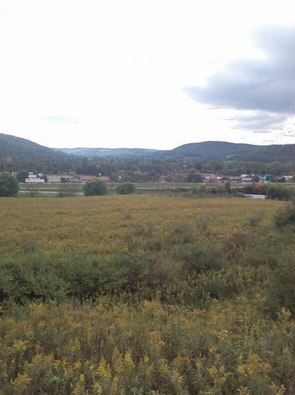
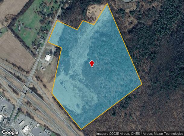
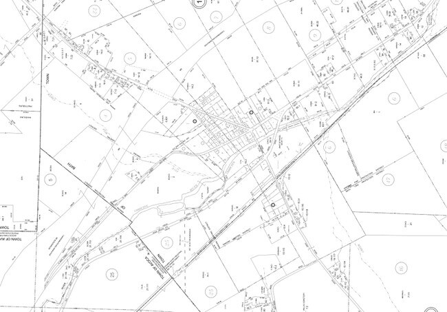
Property Record
State Route 53, Bath, NY 14810
NEARBY LISTINGS FOR SALE OR LEASE
-
-
View all Bath listings for sale on LoopNet.com
Property Detail
State Route 53
Corning, NY
Steuben
462489-129-000-0001-014-110
New York
Residentialacreage
14.110
2025
59.68 AC
2024
Ithaca/Elmira
961100
Other Market Areas
DEMOGRAPHICS near State Route 53
1 Mile
3 Mile
5 Mile
2024 Total Population
191
1,606
10,370
2029 Population
187
1,571
10,162
Pop Growth 2024-2029
(2.09%)
(2.18%)
(2.01%)
Average Age
45
45
44
2024 Total Households
87
685
4,635
HH Growth 2024-2029
(2.30%)
(2.34%)
(2.03%)
Median Household Inc
$33,666
$40,989
$43,022
Avg Household Size
2.20
2.20
2.10
2024 Avg HH Vehicles
2.00
2.00
2.00
Median Home Value
$76,743
$94,981
$106,035
Median Year Built
1960
1967
1961
Nearby Places
- Restaurants
- Banks
- Shops
- Fitness
- Groceries
PUBLIC TRANSPORTATION
AIRPORT
Elmira/Corning Regional
DRIVE
WALK
Distance
Elmira/Corning Regional
44 min
36.1 mi
Freight Ports
Albany, NY Port
DRIVE
WALK
Distance
Albany, NY Port
281 min
237.8 mi
SALE & LEASE HISTORY
LISTING DATE
SALE/LEASE

Mar 21, 2017
For Sale
Nearby Properties
Address
Land Use
TOTAL SIZE
Lot Size
Zoning
Address
Land Use
TOTAL SIZE
Lot Size
Zoning
131,456 SF
215.80 AC
01 - NOT Z
Address
Land Use
TOTAL SIZE
Lot Size
Zoning
800 SF
12.24 AC
01 - NOT Z
Address
Land Use
TOTAL SIZE
Lot Size
Zoning
52,220 SF
36.64 AC
01 - NOT Z
Address
Land Use
TOTAL SIZE
Lot Size
Zoning
7,968 SF
11.41 AC
01 - NOT Z
Address
Land Use
TOTAL SIZE
Lot Size
Zoning
41,367 SF
9.64 AC
02 - SINGL
Address
Land Use
TOTAL SIZE
Lot Size
Zoning
3,085 SF
214.07 AC
01 - NOT Z
Address
Land Use
TOTAL SIZE
Lot Size
Zoning
27,274 SF
1.62 AC
04 - FARM
Address
Land Use
TOTAL SIZE
Lot Size
Zoning
75,560 SF
17 AC
Address
Land Use
TOTAL SIZE
Lot Size
Zoning
26,646 SF
15.40 AC
01 - NOT Z
Address
Land Use
TOTAL SIZE
Lot Size
Zoning
4,905 SF
1.24 AC
04 - FARM
Address
Land Use
TOTAL SIZE
Lot Size
Zoning
Address
Land Use
TOTAL SIZE
Lot Size
Zoning
Address
Land Use
TOTAL SIZE
Lot Size
Zoning
Address
Land Use
TOTAL SIZE
Lot Size
Zoning
25,714 SF
21.43 AC
04 - FARM
Address
Land Use
TOTAL SIZE
Lot Size
Zoning
924 SF
15.36 AC
01 - NOT Z
Address
Land Use
TOTAL SIZE
Lot Size
Zoning
8,694 SF
1.06 AC
01 - NOT Z
Address
Land Use
TOTAL SIZE
Lot Size
Zoning
2,128 SF
0.53 AC
04 - FARM
Address
Land Use
TOTAL SIZE
Lot Size
Zoning
Address
Land Use
TOTAL SIZE
Lot Size
Zoning
1,691 SF
0.65 AC
03 - MULTI
Address
Land Use
TOTAL SIZE
Lot Size
Zoning
61,205 SF
6.01 AC
04 - FARM
Address
Land Use
TOTAL SIZE
Lot Size
Zoning
6,093 SF
0.88 AC
01 - NOT Z
Address
Land Use
TOTAL SIZE
Lot Size
Zoning
24,472 SF
7.70 AC
04 - FARM
Address
Land Use
TOTAL SIZE
Lot Size
Zoning
6,000 SF
69.44 AC
01 - NOT Z
Address
Land Use
TOTAL SIZE
Lot Size
Zoning
8,200 SF
2.30 AC
01 - NOT Z
Address
Land Use
TOTAL SIZE
Lot Size
Zoning
15,824 SF
0.32 AC
04 - FARM
Address
Land Use
TOTAL SIZE
Lot Size
Zoning
7,500 SF
1.80 AC
Address
Land Use
TOTAL SIZE
Lot Size
Zoning
2,726 SF
3.99 AC
01
Address
Land Use
TOTAL SIZE
Lot Size
Zoning
840 SF
9 AC
02 - SINGL
Address
Land Use
TOTAL SIZE
Lot Size
Zoning
2,847 SF
104.04 AC
01 - NOT Z
Address
Land Use
TOTAL SIZE
Lot Size
Zoning
13,122 SF
9.59 AC
01 - NOT Z
The World's #1 Commercial Real Estate Marketplace
Connect with us
© 2025 CoStar Group
The information above has been obtained from sources believed reliable. While we do not doubt its accuracy we have not verified it and make no guarantee, warranty or representation about it. It is your responsibility to independently confirm its accuracy and completeness. Any projections, opinions, assumptions, or estimates used are for example only and do not represent the current or future performance of the property. The value of this transaction to you depends on tax and other factors which should be evaluated by your tax, financial, and legal advisors. You and your advisors should conduct a careful, independent investigation of the property to determine to your satisfaction the suitability of the property for your needs.