Property Record
State Route 8, Stow, OH 44224

Property Detail
State Route 8
Akron, OH
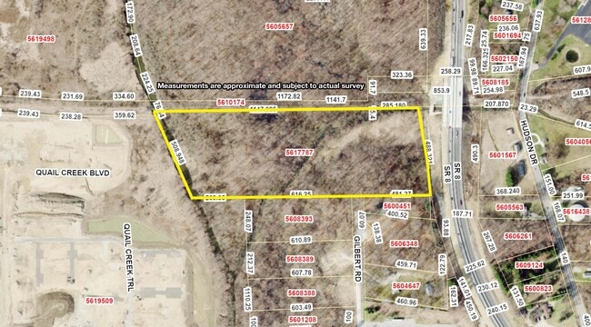
LOT 41 E OF MUD BROOK W OF SR 8 14.7421A
56-17787
SUMMIT
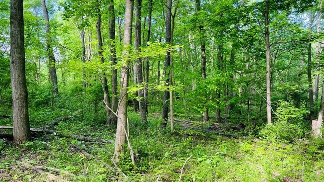
Industrialacreage
Ohio
AE The base floodplain where base flood elevations are provided. AE Zones are now used on new format FIRMs instead of A1-A30 Zones.
41
2023
14.74 AC
2025
Akron
530401
Cleveland
NEARBY LISTINGS FOR SALE OR LEASE
DEMOGRAPHICS near State Route 8
1 mile
3 mile
5 mile
2025 Total Population
6,236
64,147
133,265
2030 Population
6,302
64,061
133,173
Pop Growth 2025-2030
+ 1.06%
(0.13%)
(0.07%)
Average Age
41
42
41
2025 Total Households
2,972
28,497
57,769
HH Growth 2025-2030
+ 1.11%
(0.19%)
(0.06%)
Median Household Inc
$77,151
$79,836
$73,675
Avg Household Size
2.10
2.20
2.20
2025 Avg HH Vehicles
2.00
2.00
2.00
Median Home Value
$237,702
$208,215
$221,232
Median Year Built
1988
1966
1970
Nearby Places
Map Layers
Map Styles
 Street
 Aerial
Transit
 Traffic
 Biking
Places
Listings with unknown addresses are not visible on the map
- Restaurants
- Banks
- Shops
- Fitness
- Groceries
PUBLIC TRANSPORTATION
COMMUTER RAIL
Big Bend (National Park Scenic Railway - Cuyahoga Valley Scenic Railroad)
Drive
Walk
Distance
Big Bend (National Park Scenic Railway - Cuyahoga Valley Scenic Railroad)
14 min
5.7 mi
Botzum (National Park Scenic Railway - Cuyahoga Valley Scenic Railroad)
Drive
Walk
Distance
Botzum (National Park Scenic Railway - Cuyahoga Valley Scenic Railroad)
16 min
6.3 mi
AIRPORT
Akron-Canton Regional
Drive
Walk
Distance
Akron-Canton Regional
29 min
20.3 mi
Cleveland-Hopkins International
Drive
Walk
Distance
Cleveland-Hopkins International
50 min
35.8 mi
Freight Ports
Port of Toledo
Drive
Walk
Distance
Port of Toledo
153 min
130.3 mi
SALE & LEASE HISTORY
LISTING DATE
SALE/LEASE

Sep 24, 2016
For Sale
Jun 08, 2022
For Sale
Dec 07, 2022
For Sale
Aug 09, 2017
For Sale
Nearby Properties
Address
Land Use
TOTAL SIZE
Lot Size
Zoning
Address
Land Use
TOTAL SIZE
Lot Size
Zoning
188,042 SF
45.24 AC
Address
Land Use
TOTAL SIZE
Lot Size
Zoning
Address
Land Use
TOTAL SIZE
Lot Size
Zoning
246,181 SF
54.04 AC
Address
Land Use
TOTAL SIZE
Lot Size
Zoning
314,622 SF
15.59 AC
Address
Land Use
TOTAL SIZE
Lot Size
Zoning
297,758 SF
23.28 AC
Address
Land Use
TOTAL SIZE
Lot Size
Zoning
115,224 SF
10.30 AC
Address
Land Use
TOTAL SIZE
Lot Size
Zoning
131,124 SF
29.45 AC
Address
Land Use
TOTAL SIZE
Lot Size
Zoning
52,646 SF
69.69 AC
Address
Land Use
TOTAL SIZE
Lot Size
Zoning
396,660 SF
31.89 AC
Address
Land Use
TOTAL SIZE
Lot Size
Zoning
15.41 AC
Address
Land Use
TOTAL SIZE
Lot Size
Zoning
169,260 SF
9.95 AC
Address
Land Use
TOTAL SIZE
Lot Size
Zoning
118,740 SF
15.25 AC
Address
Land Use
TOTAL SIZE
Lot Size
Zoning
145,844 SF
9.80 AC
Address
Land Use
TOTAL SIZE
Lot Size
Zoning
Address
Land Use
TOTAL SIZE
Lot Size
Zoning
Address
Land Use
TOTAL SIZE
Lot Size
Zoning
119,896 SF
3.19 AC
Address
Land Use
TOTAL SIZE
Lot Size
Zoning
Address
Land Use
TOTAL SIZE
Lot Size
Zoning
90,820 SF
23.72 AC
Address
Land Use
TOTAL SIZE
Lot Size
Zoning
165,600 SF
11.21 AC
Address
Land Use
TOTAL SIZE
Lot Size
Zoning
68,855 SF
32.57 AC
Address
Land Use
TOTAL SIZE
Lot Size
Zoning
136,220 SF
33 AC
Address
Land Use
TOTAL SIZE
Lot Size
Zoning
140,288 SF
19.51 AC
Address
Land Use
TOTAL SIZE
Lot Size
Zoning
31,128 SF
1.48 AC
Address
Land Use
TOTAL SIZE
Lot Size
Zoning
280,603 SF
19.19 AC
Address
Land Use
TOTAL SIZE
Lot Size
Zoning
26,231 SF
14.40 AC
Address
Land Use
TOTAL SIZE
Lot Size
Zoning
118,516 SF
22.07 AC
Address
Land Use
TOTAL SIZE
Lot Size
Zoning
21.80 AC
Address
Land Use
TOTAL SIZE
Lot Size
Zoning
12.94 AC
Address
Land Use
TOTAL SIZE
Lot Size
Zoning
Address
Land Use
TOTAL SIZE
Lot Size
Zoning
70,432 SF
2.28 AC
The World's #1 Commercial Real Estate Marketplace
Connect with us
© 2026 CoStar Group
The information above has been obtained from sources believed reliable. While we do not doubt its accuracy we have not verified it and make no guarantee, warranty or representation about it. It is your responsibility to independently confirm its accuracy and completeness. Any projections, opinions, assumptions, or estimates used are for example only and do not represent the current or future performance of the property. The value of this transaction to you depends on tax and other factors which should be evaluated by your tax, financial, and legal advisors. You and your advisors should conduct a careful, independent investigation of the property to determine to your satisfaction the suitability of the property for your needs.