Property Record
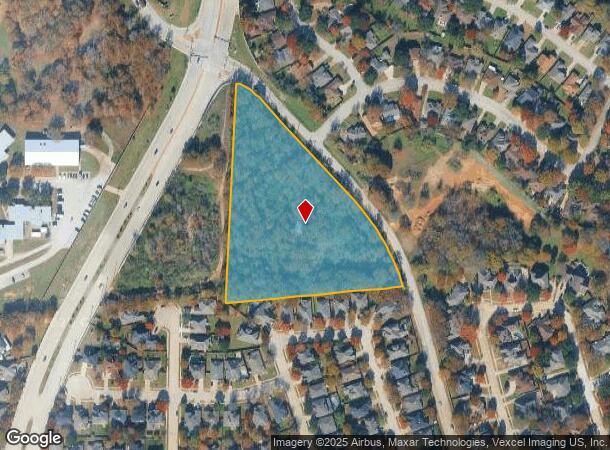
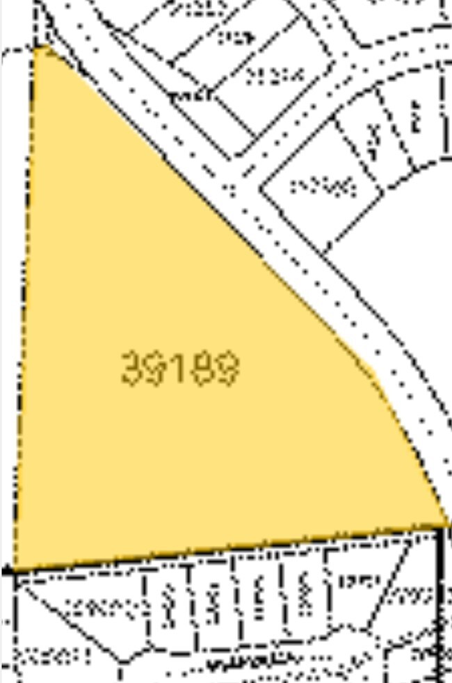
State School Rd, Denton, TX 76210

Property Detail
State School Rd
R39189
Mep & Prr
Commercialacreage
A0950A MEP & PRR, TR 32(PT), 5.5521 ACRES, OLD DCAD TR 9A
X
Denton
48121C0387H
Texas
2024
5.55 AC
2025
Denton
021417
Dallas/Ft Worth
1,008 SF
Dallas-Fort Worth-Arlington, TX
NEARBY LISTINGS FOR SALE OR LEASE
DEMOGRAPHICS near State School Rd
1 mile
3 mile
5 mile
2024 Total Population
12,447
72,985
161,584
2029 Population
14,792
87,761
194,347
Pop Growth 2024-2029
+ 18.84%
+ 20.25%
+ 20.28%
Average Age
40
39
37
2024 Total Households
4,136
26,505
59,271
HH Growth 2024-2029
+ 19.44%
+ 20.89%
+ 21.18%
Median Household Inc
$121,776
$94,404
$73,958
Avg Household Size
2.90
2.70
2.60
2024 Avg HH Vehicles
2.00
2.00
2.00
Median Home Value
$324,093
$320,441
$327,217
Median Year Built
2002
2001
1999
Nearby Places
Map Layers
Map Styles
 Street
 Aerial
Transit
 Traffic
 Biking
Places
Listings with unknown addresses are not visible on the map
- Restaurants
- Banks
- Shops
- Fitness
- Groceries
PUBLIC TRANSPORTATION
COMMUTER RAIL
Medpark Station (A-train - Denton County Transportation Authority)
Drive
Walk
Distance
Medpark Station (A-train - Denton County Transportation Authority)
4 min
1.7 mi
Downtown Denton Transit Center (A-train - Denton County Transportation Authority)
Drive
Walk
Distance
Downtown Denton Transit Center (A-train - Denton County Transportation Authority)
9 min
5.2 mi
AIRPORT
Dallas-Fort Worth International
Drive
Walk
Distance
Dallas-Fort Worth International
29 min
23.2 mi
Dallas Love Field
Drive
Walk
Distance
Dallas Love Field
41 min
32.2 mi
Freight Ports
Port of Shreveport
Drive
Walk
Distance
Port of Shreveport
248 min
229.8 mi
SALE & LEASE HISTORY
LISTING DATE
SALE/LEASE

Oct 02, 2017
For Sale
Nov 01, 2018
For Sale
Mar 02, 2021
For Sale
Feb 22, 2023
For Sale
Feb 22, 2023
For Sale
Nearby Properties
Address
Land Use
TOTAL SIZE
Lot Size
Zoning
Address
Land Use
TOTAL SIZE
Lot Size
Zoning
394,618 SF
12.29 AC
Address
Land Use
TOTAL SIZE
Lot Size
Zoning
387,383 SF
27.58 AC
Address
Land Use
TOTAL SIZE
Lot Size
Zoning
386,056 SF
81.56 AC
Address
Land Use
TOTAL SIZE
Lot Size
Zoning
310,952 SF
56.11 AC
Address
Land Use
TOTAL SIZE
Lot Size
Zoning
184,710 SF
16.82 AC
Address
Land Use
TOTAL SIZE
Lot Size
Zoning
310,772 SF
11.77 AC
Address
Land Use
TOTAL SIZE
Lot Size
Zoning
278,316 SF
17.81 AC
30G
Address
Land Use
TOTAL SIZE
Lot Size
Zoning
294,021 SF
30.81 AC
Address
Land Use
TOTAL SIZE
Lot Size
Zoning
246,535 SF
53.67 AC
Address
Land Use
TOTAL SIZE
Lot Size
Zoning
208,582 SF
8.58 AC
Address
Land Use
TOTAL SIZE
Lot Size
Zoning
191,512 SF
8.04 AC
Address
Land Use
TOTAL SIZE
Lot Size
Zoning
243,397 SF
14.43 AC
Address
Land Use
TOTAL SIZE
Lot Size
Zoning
195,121 SF
10.16 AC
30G
Address
Land Use
TOTAL SIZE
Lot Size
Zoning
226,040 SF
19.51 AC
Address
Land Use
TOTAL SIZE
Lot Size
Zoning
123,133 SF
13.05 AC
Address
Land Use
TOTAL SIZE
Lot Size
Zoning
281,644 SF
4.50 AC
30G
Address
Land Use
TOTAL SIZE
Lot Size
Zoning
229,968 SF
6.93 AC
Address
Land Use
TOTAL SIZE
Lot Size
Zoning
232,942 SF
12.58 AC
30G
Address
Land Use
TOTAL SIZE
Lot Size
Zoning
210,801 SF
6.14 AC
Address
Land Use
TOTAL SIZE
Lot Size
Zoning
176,838 SF
15.64 AC
Address
Land Use
TOTAL SIZE
Lot Size
Zoning
221,051 SF
19.24 AC
Address
Land Use
TOTAL SIZE
Lot Size
Zoning
178,272 SF
10.25 AC
Address
Land Use
TOTAL SIZE
Lot Size
Zoning
76,608 SF
22.43 AC
Address
Land Use
TOTAL SIZE
Lot Size
Zoning
276,244 SF
7.53 AC
Address
Land Use
TOTAL SIZE
Lot Size
Zoning
203,193 SF
23.34 AC
Address
Land Use
TOTAL SIZE
Lot Size
Zoning
264,138 SF
38.41 AC
Address
Land Use
TOTAL SIZE
Lot Size
Zoning
185,592 SF
14.38 AC
Address
Land Use
TOTAL SIZE
Lot Size
Zoning
229,450 SF
16.53 AC
30G
Address
Land Use
TOTAL SIZE
Lot Size
Zoning
77,887 SF
20.59 AC
Address
Land Use
TOTAL SIZE
Lot Size
Zoning
133,812 SF
7.40 AC
30G
The World's #1 Commercial Real Estate Marketplace
Connect with us
© 2026 CoStar Group
The information above has been obtained from sources believed reliable. While we do not doubt its accuracy we have not verified it and make no guarantee, warranty or representation about it. It is your responsibility to independently confirm its accuracy and completeness. Any projections, opinions, assumptions, or estimates used are for example only and do not represent the current or future performance of the property. The value of this transaction to you depends on tax and other factors which should be evaluated by your tax, financial, and legal advisors. You and your advisors should conduct a careful, independent investigation of the property to determine to your satisfaction the suitability of the property for your needs.