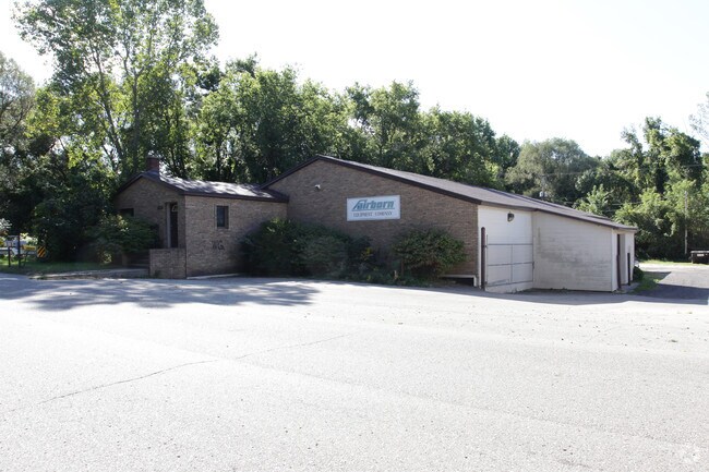
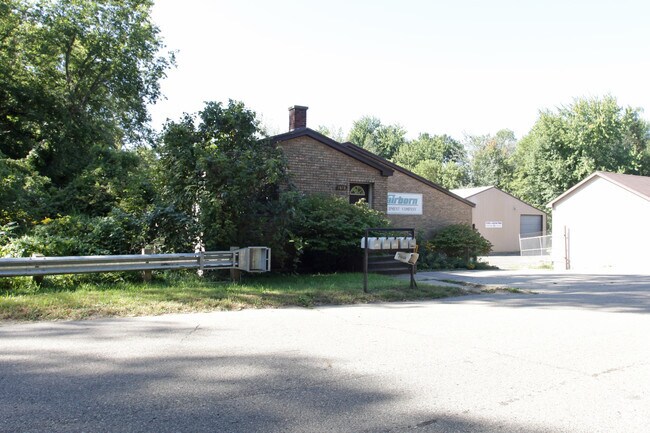
Property Record
State St, Marne, MI 49435
Property Detail
State St
70-06-34-450-019
PART OF NE 1/4 OF SE 1/4 COM N 85D14M W 31764 FT ALG CEN LI OF STATE ST FR INTERS OF CEN LI OF STATE ST & CEN LI OF WATER ST,
Commercialacreage
OTTAWA
I
Michigan
A Areas with a 1% annual chance of flooding and a 26% chance of flooding over the life of a 30-year mortgage.
0.24 AC
2025
Northern Ottawa County
2025
West Michigan
020100
Grand Rapids-Wyoming-Kentwood, MI
NEARBY LISTINGS FOR SALE OR LEASE
DEMOGRAPHICS near State St
1 mile
3 mile
5 mile
2025 Total Population
1,080
5,796
25,586
2030 Population
1,097
5,983
26,282
Pop Growth 2025-2030
+ 1.57%
+ 3.23%
+ 2.72%
Average Age
41
42
40
2025 Total Households
402
2,237
9,624
HH Growth 2025-2030
+ 1.74%
+ 3.49%
+ 2.80%
Median Household Inc
$77,817
$81,072
$78,252
Avg Household Size
2.70
2.60
2.60
2025 Avg HH Vehicles
2.00
2.00
2.00
Median Home Value
$416,837
$371,932
$310,480
Median Year Built
1974
1986
1987
Nearby Places
Map Layers
Map Styles
 Street
 Aerial
Layers
 Traffic
 Biking
Places
Listings with unknown addresses are not visible on the map
- Restaurants
- Banks
- Shops
- Fitness
- Groceries
PUBLIC TRANSPORTATION
AIRPORT
Gerald R Ford International
Drive
Walk
Distance
Gerald R Ford International
33 min
25.5 mi
Freight Ports
Port Milwaukee
Drive
Walk
Distance
Port Milwaukee
311 min
265.9 mi
Nearby Properties
Address
Land Use
TOTAL SIZE
Lot Size
Zoning
Address
Land Use
TOTAL SIZE
Lot Size
Zoning
247,168 SF
9.60 AC
MP
Address
Land Use
TOTAL SIZE
Lot Size
Zoning
140,841 SF
8.96 AC
Address
Land Use
TOTAL SIZE
Lot Size
Zoning
197,220 SF
10.94 AC
MP
Address
Land Use
TOTAL SIZE
Lot Size
Zoning
200,000 SF
13.41 AC
MP
Address
Land Use
TOTAL SIZE
Lot Size
Zoning
121,584 SF
21.98 AC
I
Address
Land Use
TOTAL SIZE
Lot Size
Zoning
195,000 SF
11.09 AC
MP
Address
Land Use
TOTAL SIZE
Lot Size
Zoning
88,113 SF
12.50 AC
Address
Land Use
TOTAL SIZE
Lot Size
Zoning
43,864 SF
NOT APP
Address
Land Use
TOTAL SIZE
Lot Size
Zoning
89,277 SF
5.06 AC
MP
Address
Land Use
TOTAL SIZE
Lot Size
Zoning
4.80 AC
Address
Land Use
TOTAL SIZE
Lot Size
Zoning
65,562 SF
8.18 AC
Address
Land Use
TOTAL SIZE
Lot Size
Zoning
73,887 SF
7.30 AC
MP
Address
Land Use
TOTAL SIZE
Lot Size
Zoning
81,298 SF
4.50 AC
MP
Address
Land Use
TOTAL SIZE
Lot Size
Zoning
76,115 SF
4.70 AC
MP
Address
Land Use
TOTAL SIZE
Lot Size
Zoning
96,406 SF
19.49 AC
I
Address
Land Use
TOTAL SIZE
Lot Size
Zoning
6,160 SF
NOT APP
Address
Land Use
TOTAL SIZE
Lot Size
Zoning
86,918 SF
8.15 AC
I
Address
Land Use
TOTAL SIZE
Lot Size
Zoning
41,375 SF
6.80 AC
MP
Address
Land Use
TOTAL SIZE
Lot Size
Zoning
66,294 SF
3.50 AC
MP
Address
Land Use
TOTAL SIZE
Lot Size
Zoning
106,388 SF
9.04 AC
MP
Address
Land Use
TOTAL SIZE
Lot Size
Zoning
117,240 SF
25.26 AC
I
Address
Land Use
TOTAL SIZE
Lot Size
Zoning
47,178 SF
2.64 AC
Address
Land Use
TOTAL SIZE
Lot Size
Zoning
45,000 SF
2.31 AC
Address
Land Use
TOTAL SIZE
Lot Size
Zoning
64,632 SF
7.04 AC
CC
Address
Land Use
TOTAL SIZE
Lot Size
Zoning
55,335 SF
6.60 AC
MP
Address
Land Use
TOTAL SIZE
Lot Size
Zoning
28,373 SF
10.38 AC
Address
Land Use
TOTAL SIZE
Lot Size
Zoning
40,095 SF
NOT APP
Address
Land Use
TOTAL SIZE
Lot Size
Zoning
51,789 SF
5.90 AC
MP
Address
Land Use
TOTAL SIZE
Lot Size
Zoning
42,157 SF
3.40 AC
MP
Address
Land Use
TOTAL SIZE
Lot Size
Zoning
40,250 SF
2.40 AC
MP
The World's #1 Commercial Real Estate Marketplace
Connect with us
© 2026 CoStar Group
The information above has been obtained from sources believed reliable. While we do not doubt its accuracy we have not verified it and make no guarantee, warranty or representation about it. It is your responsibility to independently confirm its accuracy and completeness. Any projections, opinions, assumptions, or estimates used are for example only and do not represent the current or future performance of the property. The value of this transaction to you depends on tax and other factors which should be evaluated by your tax, financial, and legal advisors. You and your advisors should conduct a careful, independent investigation of the property to determine to your satisfaction the suitability of the property for your needs.