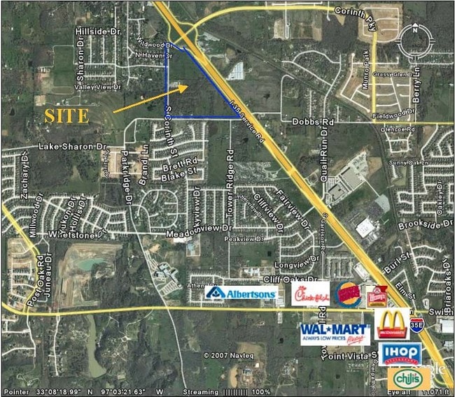
Property Record
Stemmons Fwy, Corinth, TX 76210

Property Detail
Stemmons Fwy
Dallas-Fort Worth-Arlington, TX
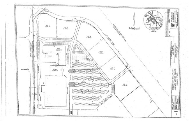
A0507A H. GARRISON, TR 17A(PT), 14.7575 ACRES
R261856
DENTON
Vacantlandnec
Texas
AE The base floodplain where base flood elevations are provided. AE Zones are now used on new format FIRMs instead of A1-A30 Zones.
14.76 AC
2024
Denton
2025
Dallas/Ft Worth
021417
NEARBY LISTINGS FOR SALE OR LEASE
DEMOGRAPHICS near Stemmons Fwy
1 mile
3 mile
5 mile
2024 Total Population
8,403
61,064
128,440
2029 Population
10,076
73,206
154,455
Pop Growth 2024-2029
+ 19.91%
+ 19.88%
+ 20.25%
Average Age
39
39
39
2024 Total Households
3,095
21,226
45,551
HH Growth 2024-2029
+ 20.52%
+ 20.47%
+ 20.88%
Median Household Inc
$99,641
$106,765
$101,001
Avg Household Size
2.70
2.80
2.80
2024 Avg HH Vehicles
2.00
2.00
2.00
Median Home Value
$285,713
$316,361
$350,183
Median Year Built
1997
2002
2000
Nearby Places
Map Layers
Map Styles
 Street
 Aerial
Transit
 Traffic
 Biking
Places
Listings with unknown addresses are not visible on the map
- Restaurants
- Banks
- Shops
- Fitness
- Groceries
PUBLIC TRANSPORTATION
COMMUTER RAIL
Medpark Station (A-train - Denton County Transportation Authority)
Drive
Walk
Distance
Medpark Station (A-train - Denton County Transportation Authority)
9 min
4.6 mi
Highland Village/Lewisville Lake Station (A-train - Denton County Transportation Authority)
Drive
Walk
Distance
Highland Village/Lewisville Lake Station (A-train - Denton County Transportation Authority)
9 min
7.0 mi
AIRPORT
Dallas-Fort Worth International
Drive
Walk
Distance
Dallas-Fort Worth International
26 min
20.1 mi
Dallas Love Field
Drive
Walk
Distance
Dallas Love Field
38 min
29.1 mi
Freight Ports
Port of Shreveport
Drive
Walk
Distance
Port of Shreveport
244 min
226.7 mi
Nearby Properties
Address
Land Use
TOTAL SIZE
Lot Size
Zoning
Address
Land Use
TOTAL SIZE
Lot Size
Zoning
387,383 SF
27.58 AC
Address
Land Use
TOTAL SIZE
Lot Size
Zoning
386,056 SF
81.56 AC
Address
Land Use
TOTAL SIZE
Lot Size
Zoning
310,952 SF
56.11 AC
Address
Land Use
TOTAL SIZE
Lot Size
Zoning
360,000 SF
24.34 AC
Address
Land Use
TOTAL SIZE
Lot Size
Zoning
246,535 SF
53.67 AC
Address
Land Use
TOTAL SIZE
Lot Size
Zoning
208,582 SF
8.58 AC
Address
Land Use
TOTAL SIZE
Lot Size
Zoning
337,537 SF
8.83 AC
Address
Land Use
TOTAL SIZE
Lot Size
Zoning
310,042 SF
12.58 AC
Address
Land Use
TOTAL SIZE
Lot Size
Zoning
229,968 SF
6.93 AC
Address
Land Use
TOTAL SIZE
Lot Size
Zoning
282,217 SF
18.64 AC
8G
Address
Land Use
TOTAL SIZE
Lot Size
Zoning
210,801 SF
6.14 AC
Address
Land Use
TOTAL SIZE
Lot Size
Zoning
176,838 SF
15.64 AC
Address
Land Use
TOTAL SIZE
Lot Size
Zoning
178,272 SF
10.25 AC
Address
Land Use
TOTAL SIZE
Lot Size
Zoning
276,244 SF
7.53 AC
Address
Land Use
TOTAL SIZE
Lot Size
Zoning
185,592 SF
14.38 AC
Address
Land Use
TOTAL SIZE
Lot Size
Zoning
77,887 SF
20.59 AC
Address
Land Use
TOTAL SIZE
Lot Size
Zoning
324,705 SF
47.74 AC
Address
Land Use
TOTAL SIZE
Lot Size
Zoning
150,104 SF
11.58 AC
Address
Land Use
TOTAL SIZE
Lot Size
Zoning
126,287 SF
31.43 AC
Address
Land Use
TOTAL SIZE
Lot Size
Zoning
150,260 SF
6.93 AC
8G
Address
Land Use
TOTAL SIZE
Lot Size
Zoning
256,043 SF
17.48 AC
Address
Land Use
TOTAL SIZE
Lot Size
Zoning
64,712 SF
7.10 AC
Address
Land Use
TOTAL SIZE
Lot Size
Zoning
158,279 SF
53.75 AC
Address
Land Use
TOTAL SIZE
Lot Size
Zoning
144,504 SF
7.30 AC
Address
Land Use
TOTAL SIZE
Lot Size
Zoning
116,516 SF
4.20 AC
Address
Land Use
TOTAL SIZE
Lot Size
Zoning
65,556 SF
12.35 AC
Address
Land Use
TOTAL SIZE
Lot Size
Zoning
80,000 SF
12.20 AC
Address
Land Use
TOTAL SIZE
Lot Size
Zoning
62,511 SF
5 AC
Address
Land Use
TOTAL SIZE
Lot Size
Zoning
197,304 SF
19.89 AC
Address
Land Use
TOTAL SIZE
Lot Size
Zoning
190,719 SF
11 AC
The World's #1 Commercial Real Estate Marketplace
Connect with us
© 2026 CoStar Group
The information above has been obtained from sources believed reliable. While we do not doubt its accuracy we have not verified it and make no guarantee, warranty or representation about it. It is your responsibility to independently confirm its accuracy and completeness. Any projections, opinions, assumptions, or estimates used are for example only and do not represent the current or future performance of the property. The value of this transaction to you depends on tax and other factors which should be evaluated by your tax, financial, and legal advisors. You and your advisors should conduct a careful, independent investigation of the property to determine to your satisfaction the suitability of the property for your needs.