Property Record
Stevens Trl, Bristol, TN 37620

Save to a Folder
{{folder.Name}}
{{folder.ListingIds.length}} Properties
{{folder.ListingIds.length}} Property
Create a New Folder
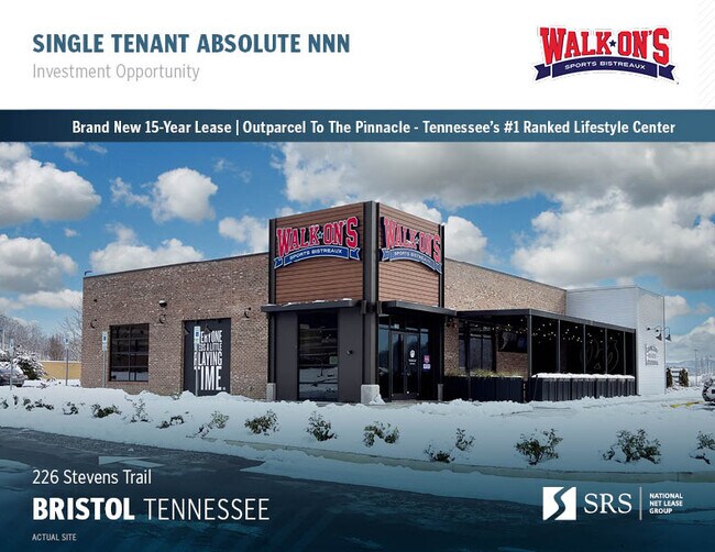
Property Detail
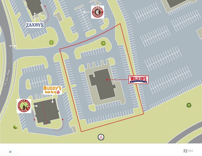
Stevens Trl
082019 19268
SULLIVAN
Restaurantbuilding
Tennessee
B and X Area of moderate flood hazard, usually the area between the limits of the 100-year and 500-year floods.
f-3b
0
1.75 AC
2025
Sullivan County
043000
Kingsport/Bristol/Bristol
6,986 SF
Kingsport-Bristol, TN-VA
NEARBY LISTINGS FOR SALE OR LEASE
-
-
No Photo
-
View all Bristol listings for sale on LoopNet.com
DEMOGRAPHICS near Stevens Trl
1 mile
3 mile
5 mile
2025 Total Population
1,433
11,243
35,782
2030 Population
1,476
11,487
36,174
Pop Growth 2025-2030
+ 3.00%
+ 2.17%
+ 1.10%
Average Age
44
44
43
2025 Total Households
614
4,793
15,673
HH Growth 2025-2030
+ 2.93%
+ 2.17%
+ 1.07%
Median Household Inc
$57,746
$57,229
$51,814
Avg Household Size
2.20
2.20
2.20
2025 Avg HH Vehicles
2.00
2.00
2.00
Median Home Value
$252,941
$198,406
$187,751
Median Year Built
1985
1977
1967
Nearby Places
Map Layers
Map Styles
 Street
 Aerial
Layers
 Traffic
 Biking
Places
Listings with unknown addresses are not visible on the map
- Restaurants
- Banks
- Shops
- Fitness
- Groceries
PUBLIC TRANSPORTATION
AIRPORT
Tri-Cities
Drive
Walk
Distance
Tri-Cities
20 min
13.4 mi
SALE & LEASE HISTORY
LISTING DATE
SALE/LEASE

Feb 06, 2024
For Sale
Nearby Properties
Address
Land Use
TOTAL SIZE
Lot Size
Zoning
Address
Land Use
TOTAL SIZE
Lot Size
Zoning
571,262 SF
37.48 AC
Address
Land Use
TOTAL SIZE
Lot Size
Zoning
99,923 SF
17.39 AC
A1
Address
Land Use
TOTAL SIZE
Lot Size
Zoning
13,934 SF
16.54 AC
Address
Land Use
TOTAL SIZE
Lot Size
Zoning
50,330 SF
17.81 AC
Address
Land Use
TOTAL SIZE
Lot Size
Zoning
18,560 SF
13.79 AC
Address
Land Use
TOTAL SIZE
Lot Size
Zoning
56,822 SF
5.09 AC
Address
Land Use
TOTAL SIZE
Lot Size
Zoning
53,350 SF
1.25 AC
Address
Land Use
TOTAL SIZE
Lot Size
Zoning
81,150 SF
6.18 AC
Address
Land Use
TOTAL SIZE
Lot Size
Zoning
54,162 SF
9.31 AC
A2 AGRICUL
Address
Land Use
TOTAL SIZE
Lot Size
Zoning
13,316 SF
6.45 AC
Address
Land Use
TOTAL SIZE
Lot Size
Zoning
131,928 SF
9.24 AC
Address
Land Use
TOTAL SIZE
Lot Size
Zoning
85,950 SF
5.03 AC
PBD
Address
Land Use
TOTAL SIZE
Lot Size
Zoning
16,228 SF
7.92 AC
Address
Land Use
TOTAL SIZE
Lot Size
Zoning
101.72 AC
A1
Address
Land Use
TOTAL SIZE
Lot Size
Zoning
61,362 SF
7.82 AC
Address
Land Use
TOTAL SIZE
Lot Size
Zoning
10,095 SF
9.88 AC
Address
Land Use
TOTAL SIZE
Lot Size
Zoning
47,102 SF
10.58 AC
Address
Land Use
TOTAL SIZE
Lot Size
Zoning
7,036 SF
5.94 AC
Address
Land Use
TOTAL SIZE
Lot Size
Zoning
151.08 AC
B2 BUSINES
Address
Land Use
TOTAL SIZE
Lot Size
Zoning
68,736 SF
15.09 AC
Address
Land Use
TOTAL SIZE
Lot Size
Zoning
55,578 SF
1.91 AC
Address
Land Use
TOTAL SIZE
Lot Size
Zoning
70,293 SF
6.97 AC
Address
Land Use
TOTAL SIZE
Lot Size
Zoning
29,072 SF
1.62 AC
Address
Land Use
TOTAL SIZE
Lot Size
Zoning
47,835 SF
9.43 AC
Address
Land Use
TOTAL SIZE
Lot Size
Zoning
48,031 SF
11.12 AC
B3
Address
Land Use
TOTAL SIZE
Lot Size
Zoning
78,103 SF
13.58 AC
Address
Land Use
TOTAL SIZE
Lot Size
Zoning
35,519 SF
5.50 AC
Address
Land Use
TOTAL SIZE
Lot Size
Zoning
64,702 SF
6.65 AC
Address
Land Use
TOTAL SIZE
Lot Size
Zoning
21,881 SF
2.39 AC
Address
Land Use
TOTAL SIZE
Lot Size
Zoning
34,482 SF
1.90 AC
The World's #1 Commercial Real Estate Marketplace
Connect with us
© 2026 CoStar Group
The information above has been obtained from sources believed reliable. While we do not doubt its accuracy we have not verified it and make no guarantee, warranty or representation about it. It is your responsibility to independently confirm its accuracy and completeness. Any projections, opinions, assumptions, or estimates used are for example only and do not represent the current or future performance of the property. The value of this transaction to you depends on tax and other factors which should be evaluated by your tax, financial, and legal advisors. You and your advisors should conduct a careful, independent investigation of the property to determine to your satisfaction the suitability of the property for your needs.