Property Record
Stevenson Rd, Smithsburg, MD 21783

Property Detail
Stevenson Rd
Hagerstown-Martinsburg, MD-WV
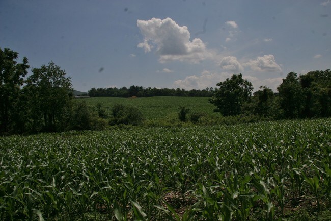
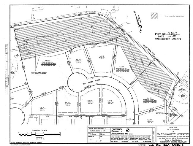
24.35 ACRES S/S EAGLE NEST ROAD E/S BRADBURY AVE
07-005180
WASHINGTON
Residentialacreage
Maryland
SR
swm
A Areas with a 1% annual chance of flooding and a 26% chance of flooding over the life of a 30-year mortgage.
24.35 AC
2024
Washington County
2025
Washington, DC
011301
NEARBY LISTINGS FOR SALE OR LEASE
DEMOGRAPHICS near Stevenson Rd
1 mile
3 mile
5 mile
2024 Total Population
2,469
6,918
13,940
2029 Population
2,441
6,906
14,184
Pop Growth 2024-2029
(1.13%)
(0.17%)
+ 1.75%
Average Age
39
41
42
2024 Total Households
885
2,509
5,165
HH Growth 2024-2029
(1.24%)
(0.12%)
+ 1.88%
Median Household Inc
$85,956
$82,552
$84,311
Avg Household Size
2.80
2.70
2.70
2024 Avg HH Vehicles
2.00
2.00
2.00
Median Home Value
$270,031
$296,449
$303,846
Median Year Built
1989
1979
1977
Nearby Places
Map Layers
Map Styles
 Street
 Aerial
Transit
 Traffic
 Biking
Places
Listings with unknown addresses are not visible on the map
- Restaurants
- Banks
- Shops
- Fitness
- Groceries
PUBLIC TRANSPORTATION
AIRPORT
Hagerstown Regional/Richard A Henson Field
Drive
Walk
Distance
Hagerstown Regional/Richard A Henson Field
25 min
13.6 mi
Freight Ports
Port of Baltimore
Drive
Walk
Distance
Port of Baltimore
93 min
75.5 mi
SALE & LEASE HISTORY
LISTING DATE
SALE/LEASE

Sep 24, 2016
For Sale
Nearby Properties
Address
Land Use
TOTAL SIZE
Lot Size
Zoning
Address
Land Use
TOTAL SIZE
Lot Size
Zoning
9,340 SF
69.58 AC
U
Address
Land Use
TOTAL SIZE
Lot Size
Zoning
1,152 SF
27.83 AC
U
Address
Land Use
TOTAL SIZE
Lot Size
Zoning
7,896 SF
10.94 AC
U
Address
Land Use
TOTAL SIZE
Lot Size
Zoning
40,777 SF
14.41 AC
A(R)
Address
Land Use
TOTAL SIZE
Lot Size
Zoning
17,732 SF
5.71 AC
BL
Address
Land Use
TOTAL SIZE
Lot Size
Zoning
48,277 SF
5.77 AC
IR
Address
Land Use
TOTAL SIZE
Lot Size
Zoning
32,759 SF
7 AC
A
Address
Land Use
TOTAL SIZE
Lot Size
Zoning
3,500 SF
2.03 AC
BL
Address
Land Use
TOTAL SIZE
Lot Size
Zoning
5.19 AC
U
Address
Land Use
TOTAL SIZE
Lot Size
Zoning
4,558 SF
9.06 AC
U
Address
Land Use
TOTAL SIZE
Lot Size
Zoning
36,000 SF
4.98 AC
IR
Address
Land Use
TOTAL SIZE
Lot Size
Zoning
490 SF
19.97 AC
RR
Address
Land Use
TOTAL SIZE
Lot Size
Zoning
5.86 AC
TR
Address
Land Use
TOTAL SIZE
Lot Size
Zoning
2,134 SF
0.99 AC
BL
Address
Land Use
TOTAL SIZE
Lot Size
Zoning
6,580 SF
30.71 AC
U
Address
Land Use
TOTAL SIZE
Lot Size
Zoning
8,715 SF
2 AC
TR
Address
Land Use
TOTAL SIZE
Lot Size
Zoning
7,470 SF
1.10 AC
BL
Address
Land Use
TOTAL SIZE
Lot Size
Zoning
1,650 SF
2 AC
BL
Address
Land Use
TOTAL SIZE
Lot Size
Zoning
9,185 SF
1.81 AC
BT
Address
Land Use
TOTAL SIZE
Lot Size
Zoning
30,296 SF
3.02 AC
U
Address
Land Use
TOTAL SIZE
Lot Size
Zoning
2,748 SF
6.07 AC
EC
Address
Land Use
TOTAL SIZE
Lot Size
Zoning
4,814 SF
3 AC
RV
Address
Land Use
TOTAL SIZE
Lot Size
Zoning
12,315 SF
8.60 AC
U
Address
Land Use
TOTAL SIZE
Lot Size
Zoning
3,298 SF
3.50 AC
EC(T)
Address
Land Use
TOTAL SIZE
Lot Size
Zoning
42,784 SF
1.14 AC
TC
Address
Land Use
TOTAL SIZE
Lot Size
Zoning
2,480 SF
4.72 AC
A
Address
Land Use
TOTAL SIZE
Lot Size
Zoning
6,598 SF
4 AC
RR
Address
Land Use
TOTAL SIZE
Lot Size
Zoning
18,248 SF
2.98 AC
A
Address
Land Use
TOTAL SIZE
Lot Size
Zoning
1,008 SF
0.45 AC
TC
Address
Land Use
TOTAL SIZE
Lot Size
Zoning
1.39 AC
BL
The World's #1 Commercial Real Estate Marketplace
Connect with us
© 2026 CoStar Group
The information above has been obtained from sources believed reliable. While we do not doubt its accuracy we have not verified it and make no guarantee, warranty or representation about it. It is your responsibility to independently confirm its accuracy and completeness. Any projections, opinions, assumptions, or estimates used are for example only and do not represent the current or future performance of the property. The value of this transaction to you depends on tax and other factors which should be evaluated by your tax, financial, and legal advisors. You and your advisors should conduct a careful, independent investigation of the property to determine to your satisfaction the suitability of the property for your needs.