Property Record
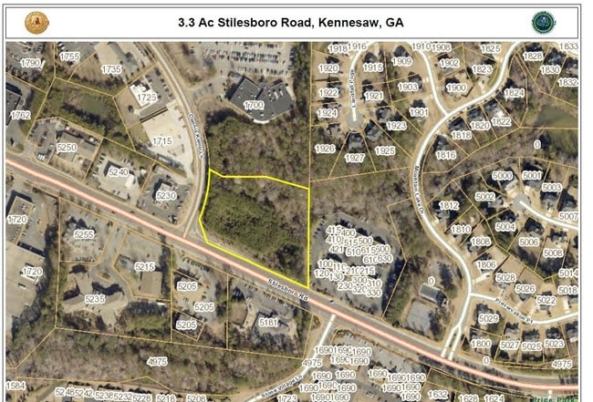
Stilesboro Rd, Kennesaw, GA 30152

This Property Is For Sale
NEARBY LISTINGS FOR SALE OR LEASE
Property Detail
Stilesboro Rd
Atlanta-Sandy Springs-Roswell, GA
ALL THAT TRACT OR PARCEL OF LAND LYING AND BEING IN THE 20TH DISTRICT, 2ND SECTION, COBB COUNTY, GEORGIA, LYING WITHIN LAND LOT 0224, IDENTIFIED AS TAX PARCEL 016, ON THE FIELD
20-0224-0-016-0
Cobb
Commercialacreage
Georgia
X
224
13067C0077G
3.39 AC
2025
Kennesaw/Town Center
2025
Atlanta
030244
DEMOGRAPHICS near Stilesboro Rd
1 Mile
3 Mile
5 Mile
2024 Total Population
6,158
41,242
119,334
2029 Population
6,191
42,031
125,094
Pop Growth 2024-2029
+ 0.54%
+ 1.91%
+ 4.83%
Average Age
41
40
40
2024 Total Households
1,967
13,307
39,980
HH Growth 2024-2029
+ 0.56%
+ 1.91%
+ 4.74%
Median Household Inc
$150,872
$134,249
$117,451
Avg Household Size
3.10
3.10
2.90
2024 Avg HH Vehicles
3.00
3.00
2.00
Median Home Value
$426,268
$412,631
$354,797
Median Year Built
1997
1996
1997
Nearby Places
Map Layers
Map Styles
 Street
 Aerial
- Restaurants
- Banks
- Shops
- Fitness
- Groceries
PUBLIC TRANSPORTATION
AIRPORT
Hartsfield - Jackson Atlanta International
DRIVE
WALK
Distance
Hartsfield - Jackson Atlanta International
57 min
39.7 mi
Nearby Properties
Address
Land Use
TOTAL SIZE
Lot Size
Zoning
Address
Land Use
TOTAL SIZE
Lot Size
Zoning
83.83 AC
R30
Address
Land Use
TOTAL SIZE
Lot Size
Zoning
2,584 SF
6.20 AC
RSL
Address
Land Use
TOTAL SIZE
Lot Size
Zoning
118,665 SF
15.42 AC
C2
Address
Land Use
TOTAL SIZE
Lot Size
Zoning
109,626 SF
15.58 AC
C2
Address
Land Use
TOTAL SIZE
Lot Size
Zoning
71.64 AC
Address
Land Use
TOTAL SIZE
Lot Size
Zoning
109,347 SF
4.69 AC
C2
Address
Land Use
TOTAL SIZE
Lot Size
Zoning
8.61 AC
C-2
Address
Land Use
TOTAL SIZE
Lot Size
Zoning
62,292 SF
8.41 AC
GC/WS
Address
Land Use
TOTAL SIZE
Lot Size
Zoning
35,400 SF
6.72 AC
GC
Address
Land Use
TOTAL SIZE
Lot Size
Zoning
49,768 SF
3.01 AC
O&I/WS
Address
Land Use
TOTAL SIZE
Lot Size
Zoning
54,902 SF
11.12 AC
NRC/LRO
Address
Land Use
TOTAL SIZE
Lot Size
Zoning
33,355 SF
4.30 AC
NRC
Address
Land Use
TOTAL SIZE
Lot Size
Zoning
38,674 SF
3.08 AC
NRC
Address
Land Use
TOTAL SIZE
Lot Size
Zoning
18,577 SF
1.95 AC
NRC
Address
Land Use
TOTAL SIZE
Lot Size
Zoning
16,972 SF
2.73 AC
C2
Address
Land Use
TOTAL SIZE
Lot Size
Zoning
33,778 SF
59.02 AC
PD
Address
Land Use
TOTAL SIZE
Lot Size
Zoning
17,426 SF
20.97 AC
Address
Land Use
TOTAL SIZE
Lot Size
Zoning
18,196 SF
1.10 AC
LRO
Address
Land Use
TOTAL SIZE
Lot Size
Zoning
10,196 SF
1.36 AC
C2
Address
Land Use
TOTAL SIZE
Lot Size
Zoning
766.99 AC
Address
Land Use
TOTAL SIZE
Lot Size
Zoning
16,405 SF
1.91 AC
NRC
Address
Land Use
TOTAL SIZE
Lot Size
Zoning
13,135 SF
0.36 AC
NRC/WS
Address
Land Use
TOTAL SIZE
Lot Size
Zoning
13,135 SF
0.36 AC
NRC/WS
Address
Land Use
TOTAL SIZE
Lot Size
Zoning
Address
Land Use
TOTAL SIZE
Lot Size
Zoning
19,508 SF
19.30 AC
Address
Land Use
TOTAL SIZE
Lot Size
Zoning
3.29 AC
GC/O&I
Address
Land Use
TOTAL SIZE
Lot Size
Zoning
24,783 SF
12.74 AC
R30
Address
Land Use
TOTAL SIZE
Lot Size
Zoning
9.80 AC
R30
Address
Land Use
TOTAL SIZE
Lot Size
Zoning
11,200 SF
1.12 AC
TS
Address
Land Use
TOTAL SIZE
Lot Size
Zoning
14,000 SF
1.96 AC
GC/O&I
The World's #1 Commercial Real Estate Marketplace
Connect with us
© 2026 CoStar Group
The information above has been obtained from sources believed reliable. While we do not doubt its accuracy we have not verified it and make no guarantee, warranty or representation about it. It is your responsibility to independently confirm its accuracy and completeness. Any projections, opinions, assumptions, or estimates used are for example only and do not represent the current or future performance of the property. The value of this transaction to you depends on tax and other factors which should be evaluated by your tax, financial, and legal advisors. You and your advisors should conduct a careful, independent investigation of the property to determine to your satisfaction the suitability of the property for your needs.